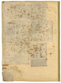
Page 48 of the City Engineer's Plat Book with five plats. Plat 1 shows lots located between Smith Street and King Street, and Radcliffe Street and Vanderhorst Street, including stretches of Thomas Street, Coming Street, St. Philip Street, and King Street. Plat 2 shows lots and buildings located near the intersection of King Street and South Bay Street. Plat 3 shows land near the intersection between Congress Street and Legare Street, and includes stretches of Hayne Street, Mount Street, and President Street. Plat 3 also shows some land labelled "City Land Potters Field." Plat 4 shows lots and a set of buildings located near Broad Street and Savage Street. Plat 5 shows lots and some buildings located on Gadsden Street.
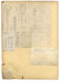
Page 22 of the City Engineer's Plat Book with five plats. Plat 1 shows lots located near the Charleston Harbor, Concord Street, Pinckney Street, and Pritchard Street. Plat 2 shows lots and structures located near the intersection of Concord Street and Pinckney Street, including a single-story building, a wharf, and a label reading "City property leased." Plat 3 shows a lot on Broad Street labelled "Lot of David McCredie." Plat 4 Shows lots located near Park Street, and between Shepherd Street and Line Street. Plat 5 shows lots near the intersection of Broad Street and Gadsden's Alley labelled with the names of banks.