Page 62 of the City Engineer's Plat Book with eight plats. Plat 1 shows lots located near East Bay Street. Plat 2 shows a lot on Concord Street, including a wharf. Plat 3 shows three Wharf Lots on Wharf Street, near the intersection with Inspection Street. Plat 4 features a lot on Wharf Street with a dock and a brick building, across the street from a building labelled "Eagle Foundry." Plat 5 shows a lot with several buildings on East Bay Street. Plat 6 shows land near the intersection of East Bay Street and Cumberland Street, with a stretch labelled "Passage to what is now called Central Wharves." Plat 7 shows a wharf and yard on Concord Street, and a structure labelled "Cotton Shed on Brick Pillars." Plat 8 shows a lot located at the intersection of Anson Street and Calhoun Street.
A list of burials with occasional notations on the individuals. Makes notations on the deaths of a refugee from Auburn, a wounded soldier from the Confederate Army and a soldier who died at the age of nineteen in the hands of "the enemy."
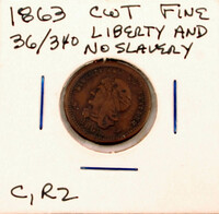
Patriotic Civil War token with an anti-slavery message. Face image of the token reads "Liberty and No Slavery 1863" and contains an image of Lady Liberty. Obverse image of the token, depicting crossed United States flags, a shield, a liberty cap on a pike, and a garland of laurel leaves with 13 stars.
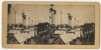
Stereoscopic image of a view of military camp showing groups of tents and palm trees. The handwritten caption on the verso reads, "Camp on Folly Island SC. Sept 1863."
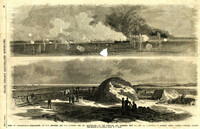
Caption: 'Siege of Charleston--1.Bombardment of Fort Moultrie and the Batteries Bee and Beauregard, by the monitors and ironsides, Sept. 7th and 8th.--2. Interior of Battery Gregg, looking towards Wagner. From sketches by our Special Artist, W.T. Crane.' [full date October 3, 1863.]
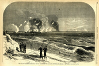
Caption: 'The Siege of Charleston--bombardment of Fort Moultrie by the iron-clads, September 8, 1863.--sketched by Mr. Theodore R. Davis.--[see page 621.] Also identified in the image: Moultrieville, Fort Moultrie and Moultrie House. [full date September 26, 1863.]
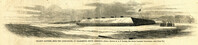
Caption: 'Night after the fight--the iron clads at anchor off Fort Sumter.--sketched by our Special Artist, Mr. W.T. Crane.--see page 81.' [full date May 2, 1863.]
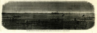
Caption: 'The siege of Charleston--View from the sea-face of Fort Wagner.--sketched by Mr. Theodore R. Davis.--[See Page 621.]' [full date September 26, 1863.]
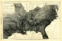
Caption: 'Map of the Southern states, showing the relative proportion of slaves in the different localities.--[see page 142.]' [full date February 28, 1863.]
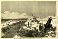
Caption: 'Folley's (sic) Battery, near the lighthouse, at Charleston, South Carolina.--from a sketch by A.P. Palmer, 21st South Carolina Volunteers.--[see page 79.]' [full date January 31, 1863.]