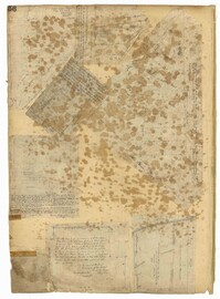
Page 56 of the City Engineer's Plat Book with seven plats. Plat 1 shows lots between Savage Street and Tradd Street. Plat 2 shows lots and some buildings on South Bay Street. Plat 3 shows lots between Savage Street and Broad Street. Plat 4 shows a lot and several buildings at the intersection of Friend and Queen Street. Plat 5 shows land near the corner of Legare Street and Gibbes Street, and a few buildings. Plat 6 shows a lot on the west side of Friend Street. Plat 7 shows lots located between Broad Street and Tradd Street, and between Lynch Street and the Ashley River.
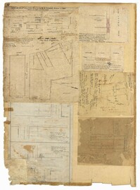
Page 4 of the City Engineer's Plat Book with seven plats. Plat 1 features East Bay Street, Pinckney Street, Concord Street, and lots labelled "Burnt District." Plat 2 features lots on King Street. Plat 3 shows several lots on East Bay Street near the intersections with Pritchard Street and Hard Alley. Plat 4 shows three lots on East Bay Street. Plat 5 features lots at the intersection of East Bay Street and Hasell Street. Plat 5 shows a stretch of Queen Street including the intersections with Archdale Street and Friend Street, and includes a plat labelled "Catholic Church." Plat 7 shows plots of land on the intersection of Tradd Street and Meeting Street.
Page 28 of the City Engineer's Plat Book with three plats. Plat 1 shows lots located near Calhoun Street, Bull Street, South Street, Ashley Street, Rutledge Street Lynch Street, and Bennett Street. Plat 1 also shows lots labelled "The Mall," and Lots Belonging to Sundry Persons. Plat 2 shows lots and buildings located near the intersection of Calhoun Street and Lucas Street, including lots labelled "Mansion Lot" and "Left for a Public Square." Plat 3 shows lots and buildings located near Bee Street, between Ashley Street and Rutledge Street.
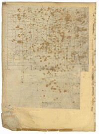
Page 38 of the City Engineer's Plat Book with two plats. Plat 1 shows lots located near Calhoun Street, some buildings, "Lots Belonging to Sundry Persons," and "The Mall." Plat 1 also shows Bennett Street, Ashley Street, Rutledge Street, Gadsden Street, and Lynch Street. Plat 2 features a lot on Smith Street.
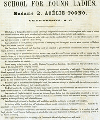
Printed broadside includes description of curriculum, rules of conduct, tuition and refereces. Madame Rosalie Acelie Togno opened her french and english boarding school for young ladies in Charleston under the patronage of James Louis Petigru in 1854. Initially located on Tradd Street, the school and dormitory for students was relocated to Meeting Street soon after. Togno was a fluent speaker of french and arrived in Charleston by way of New York. Her strict teaching style set new standards for education in antebellum Charleston and students were instructed in science, history, geograph and writing . Madame Togno's students included such notable women as Adele Allston Vanderhorst and Elizabeth Allston Waties Pringle. During the Civil War, Togno relocated her school to Barhamville, South Carolina but was forced to flee South Carolina soon after.
Page 36 of the City Engineer's Plat Book with three plats. Plat 1 shows land located near President Street and Rutledge Avenue, and labels certain marshlands and bodies of water. Plat 2 shows lots located near the intersection of King Street and Grove Street, near Milligan Street. Plat 3 shows land and buildings located near the intersection of Pitt Street and Bull Street.
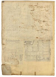
Page 15 of the City Engineer's Plat Book with three plats. Plat 1 features plots located between Rutledge Street and Smith Street, near the intersections with Queen Street. Plat 2 features a lot on the corner of Tradd Street and Savage Street. Plat 3 shows the intersection of Calhoun Street and Rutledge Avenue (also labelled as Rutledge Street) with proposed changes.
Volume contains a chronological record (1855-1856) of the number of bushels, tolls, vessels on which the rice arrived, names of individuals (plantation owners), where the rice was stored (floor and "binn") and the marks used, the names of factors, the vessels on which rice was shipped, and other data. Mill accounts contain expenses for rice, drayage, coopers, carpenters, watchman, Negroes (hire), labor, salaries of various individuals, repairs, baskets and brooms, rice, cords of wood, poles, barrels, mill stones, wharf building, cart license, a butcher's bill, horses, insurance on rice, discount on a note, sales of rice, ironwork, sweep chimney, blacksmith work, and other expenses. Income is from cash received at mill, from various individuals for rice flour and rice, from freight and tolls on rice, from notes, and from other items. The Cannonsborough Mills, begun in 1825 by former Governor Thomas Bennett, included twenty-two pestles driven by steam and fourteen pestles run by tide power. Its property fronted Ashley River a third of a mile. In 1847 Bennett deeded the property to his son-in-law, Jonathan Lucas, III. The larger of the Cannonsborough mills burnt in February of 1860.