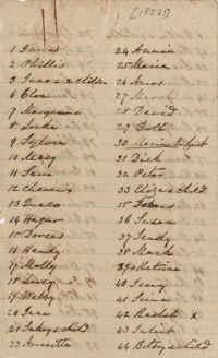
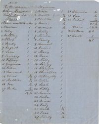
List of 118 slaves, (location and exact date unknown), numbered in pen and an additional 12 duplicate names listed at the end in pencil. The list was perhaps compiled as an inventory of property after the death of Nathaniel Heyward (1766-1851). 3p.
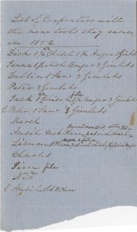
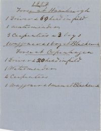
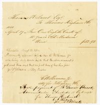
Short list of the number of slaves at Rotterdam and Hamburgh Plantations in 1852 delineated by trade, i.e. field hand, carpenter, waterminder and waggoner. 2p.
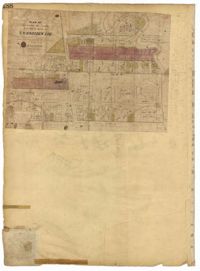
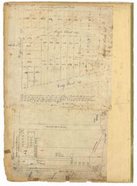
Page 188 of the City Engineer's Plat Book with one plat. The plat shows lots located between Chesnut Street and President Street, and between Bee Street and a creek. It also shows Spring Street.
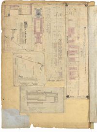
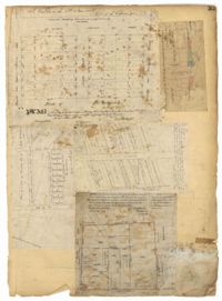
Page 92 of the City Engineer's Plat Book with six plats. Plat 1 features a "Plan of the Citadel Square," located between King Street and Meeting Street, and between Calhoun Street and Hudson Street. Plat 1 also shows several buildings, including the Citadel, the "U.S. Gov. Stables," and the "U.S. Hospital." Plat 2 shows lots and several buildings located between Smith Street and Franklin Street. Plat 3 shows lots and structures located along Market Street, between Church Street and Meeting Street. Plat 4 shows lots and structures located near Calhoun Street. Plat 5 shows several lots and structures located on King Street. Plat 6 is affixed to the page so it folds out, and shows lots located near Spring Street, between Chesnut Street and President Street. Plat 6 also shows Pine Street, Cannons Court, and Bee Street.
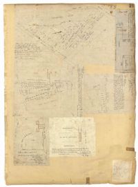
Page 55 of the City Engineer's Plat Book with five plats. Plat 1 shows lots near the intersection of Broad Street and Queen Street. Plat 2 shows lots and some buildings on Broad Street. Plat 3 shows land and buildings between Broad Street and Short Street, near their intersections with Mazyck Street. Plat 4 shows lots near Broad Street, Franklin Street, and Trapman Street. Plat 5 shows lots between Broad Street and Short Street, near their intersections Mayzck Street.
Page 33 of the City Engineer's Plat Book with five plats. Plat 1 shows land located near Mount Street's intersections with "Payne late Legare Street," Larne Court, and "Rutledge late Pinckney Street," including a stretch labelled "Flat Land." Plat 2 shows lots located near the intersection of Beaufain Street and King Street. Plat 3 shows lots located on "Council or New Street," near Gibbes Street, Smith Street, Beaufain Street, Tradd Street, New Street, and Savage Street. Plat 4 shows lots located along South Bay Street, between King Street and Meeting Street. Plat 5 shows lots, buildings, and structures located near the intersection of Line Street and Nassau Street.
Page 21 of the City Engineer's Plat Book with six plats. Plat 1 shows land between Broad Street and Tradd Street, and Logan Street and New Street, including a sizable portion labelled "Middletons Lots." Plat 2 shows a lot on Broad Street and its buildings. Plat 3 shows lots located near Rutledge Street, Queen Street, Beaufain Street, and Smith Street, and some "City marshlands." Plat 4 shows plots located near Rutledge Street, Beaufain Street, Queen Street, and Smith Street. Plat 5 shows a lot and buildings located near the intersection of Queen Street and Mazyck Street. Plat 6 shows lots of land located on King Street, including one labelled "Unitarian Church."
Page 18 of the City Engineer's Plat Book with two plats. Plat 1 shows lots located near King Street, Moultrieville Street, and Huger Street. Plat 2 shows lots located near the Cooper River, Charlotte Street, and Washington Street.
Page 3 of the City Engineer's Plat Book with four plats. Plat 1 features lots at the intersection of Laurens Street and East Bay Street, and labels a section of salt marsh. Plat 2 shows plots at the intersection of East Bay Street and Hasell Street. Plat 3 features three lots of land and buildings on East Bay Street. Plat 4 shows a stretch of Pinckney Street between Bay Street and the Cooper River, including several lots.
The Stoney Account Book, 1837-1838, and Plantation Daybook, 1852 is a bound volume kept by the Stoney family, possibly John Stafford Stoney, in which the first half of the book documents payments for shipping, freights, wharfage and commissions from GM Thompson, Wade Hampton II, William Cunningham, Robert E. Russell, Mary Hampton, Horace Osborne & Co., John Preston, and Nesbit Manufacturing Co. The second half of the book was written by a plantation overseer at Medway Plantation in which he documents the tasks performed by enslaved people and the slaves who missed work due to sickness. The names of the slaves are listed as: Abraham, Andrew, Beck, Bella, Bess, Binah, Bob, Brooke, Celia, Cesar, Charlot, Cily, Dido, Dinah/Old Dinah, Dolly, Edward, Elsey, Grace, Hector, Hercules, Jack, Jackey, Kate, Maully, Moses, Old Elley, Old Felix, Old Jerry, Peter, Philaskey, Philis, Pussy, Quash, Robert, Robin, Rosannah, Sam, and Samey.
The Baptism Book for Enslaved People at Walworth and Leamington Plantations, 1848-1853, is a record of enslaved men, women and children who were baptized under officiating ministers Rev. William Dehon and Rev. Christopher D. Gadsden. The book also makes notations regarding enslaved persons who were dead upon receiving baptism. The last two pages are entries about the enslaved persons who underwent the rite of confirmation.