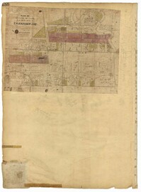
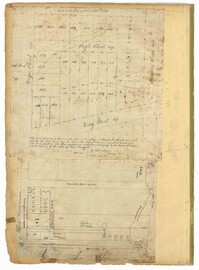
Page 188 of the City Engineer's Plat Book with one plat. The plat shows lots located between Chesnut Street and President Street, and between Bee Street and a creek. It also shows Spring Street.
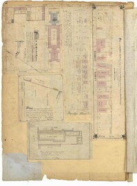
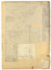
Page 92 of the City Engineer's Plat Book with six plats. Plat 1 features a "Plan of the Citadel Square," located between King Street and Meeting Street, and between Calhoun Street and Hudson Street. Plat 1 also shows several buildings, including the Citadel, the "U.S. Gov. Stables," and the "U.S. Hospital." Plat 2 shows lots and several buildings located between Smith Street and Franklin Street. Plat 3 shows lots and structures located along Market Street, between Church Street and Meeting Street. Plat 4 shows lots and structures located near Calhoun Street. Plat 5 shows several lots and structures located on King Street. Plat 6 is affixed to the page so it folds out, and shows lots located near Spring Street, between Chesnut Street and President Street. Plat 6 also shows Pine Street, Cannons Court, and Bee Street.
Page 55 of the City Engineer's Plat Book with five plats. Plat 1 shows lots near the intersection of Broad Street and Queen Street. Plat 2 shows lots and some buildings on Broad Street. Plat 3 shows land and buildings between Broad Street and Short Street, near their intersections with Mazyck Street. Plat 4 shows lots near Broad Street, Franklin Street, and Trapman Street. Plat 5 shows lots between Broad Street and Short Street, near their intersections Mayzck Street.
Page 33 of the City Engineer's Plat Book with five plats. Plat 1 shows land located near Mount Street's intersections with "Payne late Legare Street," Larne Court, and "Rutledge late Pinckney Street," including a stretch labelled "Flat Land." Plat 2 shows lots located near the intersection of Beaufain Street and King Street. Plat 3 shows lots located on "Council or New Street," near Gibbes Street, Smith Street, Beaufain Street, Tradd Street, New Street, and Savage Street. Plat 4 shows lots located along South Bay Street, between King Street and Meeting Street. Plat 5 shows lots, buildings, and structures located near the intersection of Line Street and Nassau Street.
Page 21 of the City Engineer's Plat Book with six plats. Plat 1 shows land between Broad Street and Tradd Street, and Logan Street and New Street, including a sizable portion labelled "Middletons Lots." Plat 2 shows a lot on Broad Street and its buildings. Plat 3 shows lots located near Rutledge Street, Queen Street, Beaufain Street, and Smith Street, and some "City marshlands." Plat 4 shows plots located near Rutledge Street, Beaufain Street, Queen Street, and Smith Street. Plat 5 shows a lot and buildings located near the intersection of Queen Street and Mazyck Street. Plat 6 shows lots of land located on King Street, including one labelled "Unitarian Church."
Page 18 of the City Engineer's Plat Book with two plats. Plat 1 shows lots located near King Street, Moultrieville Street, and Huger Street. Plat 2 shows lots located near the Cooper River, Charlotte Street, and Washington Street.
Page 3 of the City Engineer's Plat Book with four plats. Plat 1 features lots at the intersection of Laurens Street and East Bay Street, and labels a section of salt marsh. Plat 2 shows plots at the intersection of East Bay Street and Hasell Street. Plat 3 features three lots of land and buildings on East Bay Street. Plat 4 shows a stretch of Pinckney Street between Bay Street and the Cooper River, including several lots.