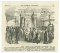
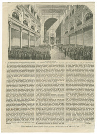
Black-and-white offset print reproduction of the interior of the Western Synagogue in St. Alban's Place in London, on the occasion of its consecration. Published in the April 19, 1851, edition of The Illustrated London News.
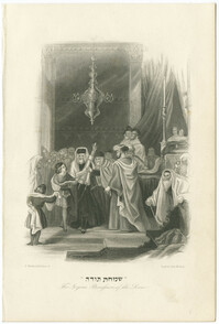
Black-and-white engraving depicting Simchat Torah in the synagogue. Engraving by John McRae. From the article "The Joy of the Law" by Mordecai Manuel Noah, published in the The Odd-Fellows’ Offering, for 1851.
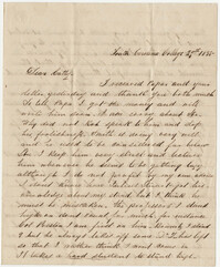
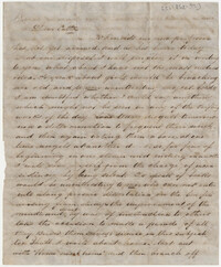
Edward Barnwell writes to sister, Catherine Osborn Barnwell, about his standing at South Carolina College and advises her to look after her physical health in addition to her education. 1851.
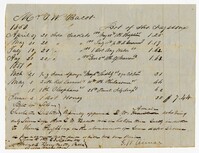
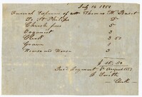
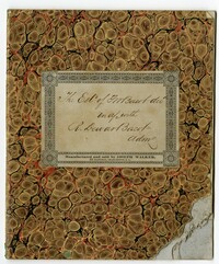
A list of items purchased by Thomas Wright Bacot before his death.The reverse side encloses that the account was paid in full by the R.D.Administration.
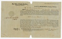
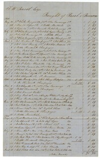
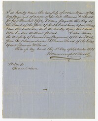
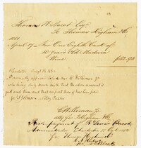
The Thomas Wright Bacot Jr. Estate Book is written by Robert Dewar Bacot between 1851-1854, following the death of Thomas W. Bacot in 1851. Acting as administrator for the estate, the book includes notices for demands against the estate, appraisals for items and belongings, including an enslaved woman named Nancy, and a written statement regarding the distribution of Thomas Bacot's shares to other members of the Bacot family.
The Baptism Book for Enslaved People at Walworth and Leamington Plantations, 1848-1853, is a record of enslaved men, women and children who were baptized under officiating ministers Rev. William Dehon and Rev. Christopher D. Gadsden. The book also makes notations regarding enslaved persons who were dead upon receiving baptism. The last two pages are entries about the enslaved persons who underwent the rite of confirmation.
The John Ball Memo Book, 1850-1851, is a bound volume listing crops at Hyde Park Plantation and the Villa as well as miscellaneous accounts for corking a dock, grass for cows, seeds for the garden, blue denim cloth, tobacco, ticking, shoes, molasses, tea and other household items. Also included is a list of men defaulting on militia duty and patrol service for January, March and April of 1851.
Page 109 of the City Engineer's Plat Book with six plats. Plat 1 shows lots located near the intersection of Exchange Street and Champney Street. Plat 2 shows lots and some buildings located on Church Street. Plat 3 shows lots located along Elliott Street, between East Bay and Church Street. Plat 4 shows lots and structures located near the corner of Church Street and Atlantic Street. Plat 5 shows lots and structures located near the corner of Church Street and Atlantic Street. Plat 6 shows lots and structures located near the intersection of East Bay Street and Guignard Street.
Page 79 of the City Engineer's Plat Book with six plats. Plat 1 shows a lots and some structures located between Doughty Street and Palmetto Street, and also shows Ashley Street and a structure labelled "United States Arsenal Wall." Plat 2 shows lots located near the intersection of Bee Street and President Street. Plat 3 shows lots located on Doughty Street, between Ashley Street and Rutledge Street. Plat 4 features lots and land located near the intersection of Bee Street and President Street. The plat also shows a mill pond and several structures. Plat 5 shows lots located between Doughty Street and Mill Street, and near Ashley Street. Plat 5 also shows Palmetto Street and a lot labelled U. S. Arsenal. Plat 6 shows lots located between Thomas Street and Pinckney Street, with several structures.
Page 82 of the City Engineer's Plat Book with five plats. Plat 1 shows lots located near the intersection of King Street with Sheppard Street. Plat 2 shows lots surrounding Hampstead Mall, between Bay Street and Meeting Street, and between Bull Street and South Street. Plat 2 also shows America Street, Amherst Street, Columbus Street, and a lot labelled "Medical Society." Plat 3 shows lots located on or near Spring Street, between King Street and Meeting Street. Plat 4 features lots near Hampstead Mall, near America Street, Aiken Street, and Columbus Street. Plat 5 features lots located on and near Meeting Street, between Woolfe Street and Columbus Street. Plat 5 also shows Nassau Street and a lot labelled "Tevole Garden."
Page 84 of the City Engineer's Plat Book with five plats. Plat 1 shows lots located near Meeting Street, between Sheppard Street and Line Street. Plat 2 shows lots located along Race Street, between Rutledge Street and King Street. Plat 3 shows lots located between King Street and Meeting Street, and shows a stretch of Russell Street. Plat 4 features a lot and several buildings located near the intersection of Line Street and Meeting Street. Plat 4 also shows a label reading "The Rail Road" and another reading "Rail Road Company." Plat 5 features a lot on Hanover Street, and also shows a lot labelled "Cemetery."
Page 73 of the City Engineer's Plat Book with six plats. Plat 1 shows lots and some buildings located near the intersection of Chapel Street and Alexander Street. Plat 2 shows lots located near King Street's intersections with Radcliffe Street, Vanderhorst Street, Hutson Street, John Street, and Ann Street. The plat also shows Meeting Street, the Mall, and a body of water. Plat 3 shows lots, structures, and marshland located near the intersection of Coming Street and Smith Street. Plat 4 shows lots and some buildings located near John Street, between King Street and a some "Rail Road Land." Plat 5 shows lots located near King Street, between Tobacco Street and Calhoun Street. Plat 6 features a stretch of land between King Street and Meeting Street, along John Street's north side and near Radcliffe Street. The plat also shows a feature labelled "Ravine."
Page 69 of the City Engineer's Plat Book with eight plats. Plat 1 shows land located on either side of Burns Lane, and also shows George Street. Plat 2 features a lot and some buildings on George Street. Plat 3 features lots located on and near King Street, between Beaufain Street and Lynch Street. Plat 4 shows a city block located between Beaufain Street and Wentworth Street, and between Pitt Street and Kirkland Lane. Plat 5 shows lots and some buildings located near the intersection of Smith Street and Montague Street. Plat 6 shows lots on Coming Street, between Montague Street and Wentworth Street. Plat 8 shows lots and some buildings located on Pitt Street, including a lot labelled "The Brown Fellowship Society Cemetery."
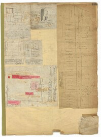
Page 45 of the City Engineer's Plat Book with nine plats. Plat 1 shows lots along New Street, located between Broad Street and Tradd Street, and shows an area labelled "City marshland." Plat 2 shows lots and buildings located between Queen Street and Cliffords Alley. Plat 3 shows land located near the intersection of Washington Street and Smith Street. Plat 4 shows lots and buildings located near the intersection of Green Street and "Comming Street." Plat 5 shows land located between "Boundary (Calhoun) Street" and George Street, and St. Phillip Street and "Comming Street," including a stretch of Green Street and College Street, and a lot labelled "College Lot." Plat 6 shows a lot located on the corner of Queen Street and King Street, and its buildings. Plat 7 shows lots located on Savage Street. Plat 8 shows lots located on Beaufain Street. Plat 9 shows lots near King Street, located between Boulevard Drive and South Bay Street.
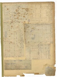
Page 46 of the City Engineer's Plat Book with five plats. Plat 1 shows lots on Butler Street, between Russell Street and Meeting Street. Plat 2 shows marshland and lots located near Huger Street and "Congress alias Pinckney Street." Plat 3 shows lots located near the intersection of "Rutledge formerly Congress Street" and Huger Street, and also shows Moultrie Street, Pinckney Street, and Legare Street. Plat 4 shows land near the intersection of King Street and Queen Street and several buildings. Plat 5 shows lots between "Hunter now Line" Street, and "Elliot St. now Spring St.," and also shows Rutledge Avenue and Boigard Street.
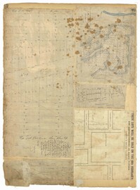
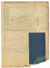
Page 39 of the City Engineer's Plat Book with five plats. Plat 1 shows lots and some buildings along East Bay Street, between the intersections with Hassell Street and Cumberland Street. Plat 2 shows lots and some buildings located between Line Street and Shepherd Street. Plat 3 shows lots located between Queen Street and Magazine Street. Plat 4 features a lot and its buildings on King Street. Plat 5 features a lot at the intersection of East Bay Street and Rose Lane.
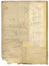
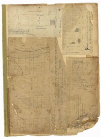
Page 16 of the City Engineer's Plat Book with five plats. Plat 1 shows lots close to the Ashley River located near Tradd Street and Gibbes Street, including a marsh flat labelled as "City Lands." Plat 2 shows lots located near the intersection of Tradd Street and Council Street, including "City marshlands." Plat 3 shows lots located near Gibbes Street and South Bay Street, and includes a dotted line labelled "Low Water Mark." Plat 4 shows land located between Ellery Street and Old Church Street, including a stretch of Raper Street. Plat 5 shows land near the intersection of South Bay Street and "Legare or Johnson Street," and close to the "Low Water" of the Ashley River.
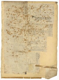
Page 7 of the City Engineer's Plat Book with four plats. Plat 1 shows lots on Bay Street. Plat 2 features plots on Hanover Street near the intersection with Reid Street and shows a lot labelled "African Burial Ground." Plat 3 features lots between Payne Street and Rutledge Street, near Fishburne Street and Market Street. Plat 4 shows lots and buildings near the intersection King Street and Broad Street. Plat 5 features lots on Cumberland Street.
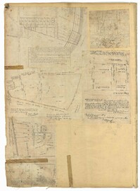
Page 9 of the City Engineer's Plat Book with four plats. Plat 1 shows lots near the intersection of Cannon Street and Smith Street. Plat 2 features plots of land and buildings located near Savage Street. Plat 3 shows plots of land located near the intersection of Queen Street and Rutledge Street. Plat 4 features lots on Simons Street.