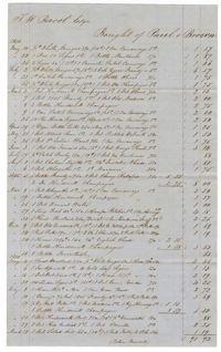
A list of items purchased by Thomas Wright Bacot before his death.The reverse side encloses that the account was paid in full by the R.D.Administration.
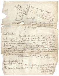
Copy of a plat of land containing 200 acres situated near Godfrey Savana in St. Bartholomew’s Parish. Names associated with this plat include Edward Fenwick, Egerton Leigh, John Brown, Hugh Crawford, John McQueen, Owen Bowen and Thomas Jones. Notable geographic locations include Godfrey's Savana [Savannah].
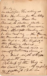
Fragments and narratives describing cities visited, often with notations re principal industries, amusements, transportation, etc. Cities visited include Paris, Ghent, Frankfurt, London, Liverpool, Sheffield, & Birmingham.
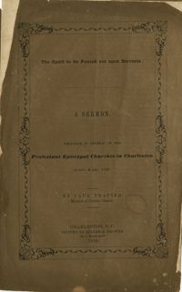
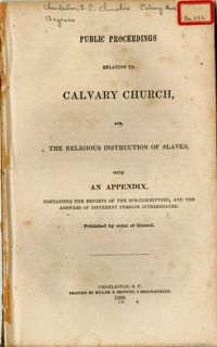
This sermon, preached in several of the Protestant Episcopal Churches in Charleston, in November and December 1849, was authored by Paul Trapier, Minister of Calvary Church. The speech charges the members of the congregation with living a life of mission in sharing the gospel with those enslaved to their care.
The pamphlet contains the Public Proceedings Relating to Calvary Church. The appendix contains the reports of the sub-committees and the written replies from those interrogated. The discourse stresses the role of paternalism in the treatment and teaching of the gospel to enslaved peoples. Many of the questions included in the interrogation refers to the modes employed when 'communicating religious instruction' to enslaved peoples. Originally bound in v. 22 of the Thomas Smith Grimke pamphlet collection.
The Baptism Book for Enslaved People at Walworth and Leamington Plantations, 1848-1853, is a record of enslaved men, women and children who were baptized under officiating ministers Rev. William Dehon and Rev. Christopher D. Gadsden. The book also makes notations regarding enslaved persons who were dead upon receiving baptism. The last two pages are entries about the enslaved persons who underwent the rite of confirmation.
The Dr. Andrew Hasell Day Book, 1840-1850, records the names of patients, which plantation they live on, illnesses or injuries, and monetary charges for medical treatments by Dr. Andrew Hasell. Patients consist of many Georgetown County families and their enslaved persons. Medical treatments include amputations, tooth extractions, diagnoses of rheumatic diseases and treatment of bone fractures.
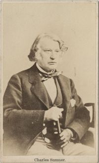
Carte de visite of Charles Sumner sitting with a cane in hand. On the back is written 'Gift From J.A. Baker'. An original envelope accompanies the photo.
The John Ball Memo Book, 1850-1851, is a bound volume listing crops at Hyde Park Plantation and the Villa as well as miscellaneous accounts for corking a dock, grass for cows, seeds for the garden, blue denim cloth, tobacco, ticking, shoes, molasses, tea and other household items. Also included is a list of men defaulting on militia duty and patrol service for January, March and April of 1851.
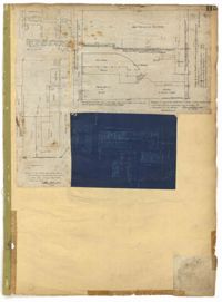
Page 115 of the City Engineer's Plat Book with four plats. Plat 1 shows land located near Broad Street, Short Street, Franklin Street, and Queen Street. Plat 2 shows lots and structures located on King Street. Plat 3 shows lots and structures located on Franklin Street. Plat 4 shows lots and structures located on Queen Street.
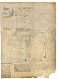
Page 77 of the City Engineer's Plat Book with seven plats, labelled 1 through 8 with Plat 3 missing. Plat 1 shows lots located between Smith Street and King Street, and between Morris Street and Radcliffe Street. Plat 1 also shows Coming Street and St. Philips Street, and a label reading "Bethlohim Congregation." Plat 2 shows lots and some structures near the intersection of King Street and Warren Street. Plat 4 shows lots between Smith Street and King Street, and north of Radcliffe Street. Plat 4 also shows Coming Street, St. Philips Street, Morris Street, and a lot labelled "Bethlehem Congregation." Plat 5 shows lots located near the intersection of Morris Street and St. Philips Street. Plat 6 shows lots located between Morris Street and "Hunter St now Line," and east of Coming Street. Plat 8 features a lot and structures located on the corner of St. Philips Street and Morris Street.
Page 83 of the City Engineer's Plat Book with eight plats. Plat 1 shows lots and some buildings located near Amherst Street, between Hanover Street and Nassau Street. Plat 2 shows lots located near the intersection of Mary Street and America Street, including a lot with structures including stables, a coach house, and a kitchen. Plat 3 shows lots located on Bay Street, near its intersections with North Street, Cooper Street, Drake Street, and Columbus Street. Plat 4 shows lots located along Drake Street, between Reid Street and Amherst Street. Plat 5 shows lots located on Meeting Street and Line Street. Plat 6 shows lots located near Line Street, between Meeting Street and Nassau Street. Plat 7 shows lots located near the intersection of Meeting Street and Columbus Street, and also shows a small Stretch of Spring Street. Plat 8 shows lots along Line Street, between Meeting Street and Aiken Street.
Page 79 of the City Engineer's Plat Book with six plats. Plat 1 shows a lots and some structures located between Doughty Street and Palmetto Street, and also shows Ashley Street and a structure labelled "United States Arsenal Wall." Plat 2 shows lots located near the intersection of Bee Street and President Street. Plat 3 shows lots located on Doughty Street, between Ashley Street and Rutledge Street. Plat 4 features lots and land located near the intersection of Bee Street and President Street. The plat also shows a mill pond and several structures. Plat 5 shows lots located between Doughty Street and Mill Street, and near Ashley Street. Plat 5 also shows Palmetto Street and a lot labelled U. S. Arsenal. Plat 6 shows lots located between Thomas Street and Pinckney Street, with several structures.