Page 115 of the City Engineer's Plat Book with four plats. Plat 1 shows land located near Broad Street, Short Street, Franklin Street, and Queen Street. Plat 2 shows lots and structures located on King Street. Plat 3 shows lots and structures located on Franklin Street. Plat 4 shows lots and structures located on Queen Street.
Page 77 of the City Engineer's Plat Book with seven plats, labelled 1 through 8 with Plat 3 missing. Plat 1 shows lots located between Smith Street and King Street, and between Morris Street and Radcliffe Street. Plat 1 also shows Coming Street and St. Philips Street, and a label reading "Bethlohim Congregation." Plat 2 shows lots and some structures near the intersection of King Street and Warren Street. Plat 4 shows lots between Smith Street and King Street, and north of Radcliffe Street. Plat 4 also shows Coming Street, St. Philips Street, Morris Street, and a lot labelled "Bethlehem Congregation." Plat 5 shows lots located near the intersection of Morris Street and St. Philips Street. Plat 6 shows lots located between Morris Street and "Hunter St now Line," and east of Coming Street. Plat 8 features a lot and structures located on the corner of St. Philips Street and Morris Street.
Page 83 of the City Engineer's Plat Book with eight plats. Plat 1 shows lots and some buildings located near Amherst Street, between Hanover Street and Nassau Street. Plat 2 shows lots located near the intersection of Mary Street and America Street, including a lot with structures including stables, a coach house, and a kitchen. Plat 3 shows lots located on Bay Street, near its intersections with North Street, Cooper Street, Drake Street, and Columbus Street. Plat 4 shows lots located along Drake Street, between Reid Street and Amherst Street. Plat 5 shows lots located on Meeting Street and Line Street. Plat 6 shows lots located near Line Street, between Meeting Street and Nassau Street. Plat 7 shows lots located near the intersection of Meeting Street and Columbus Street, and also shows a small Stretch of Spring Street. Plat 8 shows lots along Line Street, between Meeting Street and Aiken Street.
Page 79 of the City Engineer's Plat Book with six plats. Plat 1 shows a lots and some structures located between Doughty Street and Palmetto Street, and also shows Ashley Street and a structure labelled "United States Arsenal Wall." Plat 2 shows lots located near the intersection of Bee Street and President Street. Plat 3 shows lots located on Doughty Street, between Ashley Street and Rutledge Street. Plat 4 features lots and land located near the intersection of Bee Street and President Street. The plat also shows a mill pond and several structures. Plat 5 shows lots located between Doughty Street and Mill Street, and near Ashley Street. Plat 5 also shows Palmetto Street and a lot labelled U. S. Arsenal. Plat 6 shows lots located between Thomas Street and Pinckney Street, with several structures.
Page 71 of the City Engineer's Plat Book with eight plats. Plat 1 shows lots and structures on a city block between Rutledge Street and Smith Street, and between Beaufain Street and Wentworth Street. Plat 2 shows lots located near the intersection of Moore Street and Meeting Street. Plat 3 shows lots and structures located near the intersection of King Street and Beaufain Street. Plat 4 shows lots and structures located on the east side of Coming Street. Plat 5 shows lots located on King Street, including a lot labelled "Unitarian Church property" and a stretch labelled "Unitarian Church Cemetery." Plat 6 shows lots located on King Street, and shows the "Old line of street." Plat 7 shows plots located on King Street. Plat 8 features a lot and buildings located on Spring Street, and shows how Rosemont Street is projected to cross that property.
Page 75 of the City Engineer's Plat Book with six plats. Plat 1 features lots located between Radcliffe Street and Calhoun Street, and between Smith Street and Rutledge Street. Plat 1 also shows Vanderhorst Street, Thomas Street, and Warren Street. Plat 2 shows lots located near Morris Street, between St. Philips Street and Coming Street. Plat 3 shows lots located near the intersection of Morris Street and Coming Street, including a lot labelled "Cemetery" and another lot labelled "Hebrew Cemetery." Plat 4 shows land located near Thomas Street, between Doughty Street and Hutson Street, and also labels a pond. Plat 5 shows lots located between Pine Street and Gadsden Creek. Plat 6 shows lots and some buildings located between Pinckney Street and Smith Street.
Page 68 of the City Engineer's Plat Book with eight plats. Plat 1 shows lots and some structures located near the intersection of Rutledge and Wentworth Street. Plat 2 features lots and some structures located near Bull Street, between Lynch Street and Gadsden Street, and has a label reading "Mill Pond." Plat 3 shows lots and buildings located near the intersection of Bull Street and Lynch Street. Plat 4 shows a city block between Wentworth Street and Beaufain Street, and Smith Street and Rutledge Street. Plat 5 shows lots located on Beaufain Street. Plat 6 features a lot located on "Comings Street," between Wentworth Street and Montague Street. Plat 7 shows a city block located between Wentworth Street and Montague Street, and Gadsden and Lynch Street. Plat 8 shows a city block located between Lynch Street and Rutledge Street, and Wentworth Street and Beaufain Street.
Page 62 of the City Engineer's Plat Book with eight plats. Plat 1 shows lots located near East Bay Street. Plat 2 shows a lot on Concord Street, including a wharf. Plat 3 shows three Wharf Lots on Wharf Street, near the intersection with Inspection Street. Plat 4 features a lot on Wharf Street with a dock and a brick building, across the street from a building labelled "Eagle Foundry." Plat 5 shows a lot with several buildings on East Bay Street. Plat 6 shows land near the intersection of East Bay Street and Cumberland Street, with a stretch labelled "Passage to what is now called Central Wharves." Plat 7 shows a wharf and yard on Concord Street, and a structure labelled "Cotton Shed on Brick Pillars." Plat 8 shows a lot located at the intersection of Anson Street and Calhoun Street.
1862, 1885, 1850, 1815, 1866, 1873, 1830, 1833, and 1787
Description:
Page 60 of the City Engineer's Plat Book with eight plats. Plat 1 shows lots near East Bay Street, and the intersection of Washington Street and Inspection Street. Plat 2 shows lots and a building located near Market Street. Plat 3 shows lots located between Washington Street and Marsh Street, and between Inspection Street and Calhoun Street. Plat 4 shows plots located on Market Street with a dotted line labeled "Line of Street proposed by the City." Plat 5 shows plots and structures located near East Bay Street. Plat 6 shows lots located near the intersection of Concord Street and Inspection Street. Plat 7 shows lots located near the intersection of Pinckney Street and East Bay Street. Plat 8 shows a dock and wharf on the Cooper River.
Page 43 of the City Engineer's Plat Book with two plats. Plat 1 shows lots near Jasper Street, Smith Street, Marion Street, and Radcliffe Street. Plat 2 shows lots between Back Street and Marsh Street, and Magazine Street and Queen Street.
Page 2 of the City Engineer's Plat Book with five plats. Plat 1 shows the intersections of Guignard Street with East Bay Street and "Raper's Alley," and features a building labelled "Old Mansion Ruins." Plat 2 shows the intersection of East Bay Street and Market Street near the "Charleston Harbour on the Cooper River," and features plans to expand Market Street. Plat 3 features a stretch of land from the end of Rose Alley to the Cooper River, labelled as "Union Warf No. 1." Plat 4 features the same stretch of land as Plat 2 with slightly more land to the north. Plat 5 features the intersections of Tradd Street with Legare Street and Friend Street.
Page 4 of the City Engineer's Plat Book with seven plats. Plat 1 features East Bay Street, Pinckney Street, Concord Street, and lots labelled "Burnt District." Plat 2 features lots on King Street. Plat 3 shows several lots on East Bay Street near the intersections with Pritchard Street and Hard Alley. Plat 4 shows three lots on East Bay Street. Plat 5 features lots at the intersection of East Bay Street and Hasell Street. Plat 5 shows a stretch of Queen Street including the intersections with Archdale Street and Friend Street, and includes a plat labelled "Catholic Church." Plat 7 shows plots of land on the intersection of Tradd Street and Meeting Street.
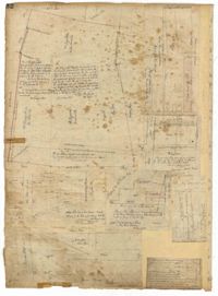
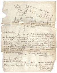
Copy of a plat of land containing 200 acres situated near Godfrey Savana in St. Bartholomew’s Parish. Names associated with this plat include Edward Fenwick, Egerton Leigh, John Brown, Hugh Crawford, John McQueen, Owen Bowen and Thomas Jones. Notable geographic locations include Godfrey's Savana [Savannah].