Page 106 of the City Engineer's Plat Book with ten plats. Plat 1 features a lot and its buildings located near the intersection of King Street and Tradd Street. Plat 2 features a lot and buildings located between Church Street and Water Street, near where the latter intersects with East Bay Street. Plat 3 shows lots located near the intersection of King Street and Grove Street. Plat 4 features a plat and building located on Church Street. Plat 5 features a lot located on the intersection of East Bay Street and Elliott Street. Plat 6 shows a lot located between two streets leading to wharves. Plat 7 shows lots, wharves, and docks located near the intersection of Market Street and East Bay Street. Plat 8 features a wharf and lot located near the intersection of Legare Street and South Bay Street. Plat 9 shows lots located on and near the intersection of Broad Street and East Bay Street. Plat 10 shows lots and some structures located on East Bay Street.
Page 64 of the City Engineer's Plat Book with six plats. Plat 1 features wharves near Concord Street and shows several other structures. Plat 2 shows "Dock Street or Queen Street" located towards the south, a structures and a creek near the center, and a lot labelled "Capt. Balls Lot" towards the north. Plat 2 also has a large label reading "Cooper River." Plat 3 shows lots located near Cumberland Street between Church Street and Philadelphia Street, and shows several structures on the lots. Plat 4 shows wharves and several buildings located between East Bay Street and the Cooper River. Plat 5 shows a stretch of land between King Street and a body of water, and also shows a stretch of Hasell Street. Plat 6 shows lots on Queen Street, and includes a lot labelled "St. Philips Church Yard." Plat 7 shows lots located near Queen Street, and has a label reading "St. Philips Church Yard."
Page 3 of the City Engineer's Plat Book with four plats. Plat 1 features lots at the intersection of Laurens Street and East Bay Street, and labels a section of salt marsh. Plat 2 shows plots at the intersection of East Bay Street and Hasell Street. Plat 3 features three lots of land and buildings on East Bay Street. Plat 4 shows a stretch of Pinckney Street between Bay Street and the Cooper River, including several lots.
The front page of the document includes the title "Bill of Sale for M. O'Connor" and the notation "J. J Palmer." The second page discusses the purchase of the slave Jim from the estate of John S. Palmer to M. O'Conner for $127. Refers to Jim as "Negro slave."
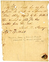
Slave pass written by Sarah H. Savage giving permission for an enslaved person named Mack to stay on Bedon's Alley for two months. The pass notes that Mack was "hired by his Mother."
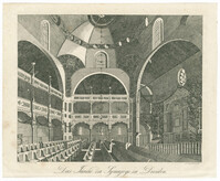
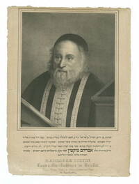
Black-and-white engraving of the interior of the Semper-Synagoge (Semper Synagogue), also known as the Dresdner Synagoge (Dresden Synagogue) or Alte Synagoge (Old Synagogue). Engraving by A. Langhans. From Erinnerungen an merkwürdige Gegenstände und Begebenheiten, Volume 23. Published Prague: C.W. Medau und Comp.

![[Crémieux]](https://rspace.library.cofc.edu/iiif/image/52671/full/200,/0/default.jpg)