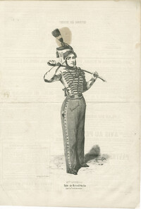
Black-and-white lithographed portrait of Mademoiselle Esther in costume for her role in Le tambour-major : vaudeville en un acte, which premiered at the Théâtre des Variétés in 1842. Lithograph printed by Rigo frères et Cie. Published in Le Charivari.
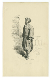
Black-and-white wood engraving of a Jewish man from Algiers. Wood engraving by Joseph Bara after Adrien Dauzats. Published in Les Français peints par eux-mêmes, Volume 3.
Hand-colored wood engraving of a Jewish man from Algiers. Wood engraving by Joseph Bara after Adrien Dauzats. Published in Les Français peints par eux-mêmes, Volume 3.
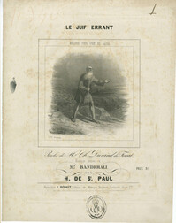
Sheet music cover for "Le juif errant : mélodie pour voix de basse," words by Ch. Durand du Fossat; music by H. de St. Paul, published Paris: S. Richault.
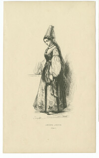
Black-and-white wood engraving of a Jewish woman from Algiers. Wood engraving by Pierre Verdeil after Hippolyte Louis Emile Pauquet. Published in Les Français peints par eux-mêmes, Volume 3.
Hand-colored wood engraving of a Jewish woman from Algiers. Wood engraving by Pierre Verdeil after Hippolyte Louis Emile Pauquet. Published in Les Français peints par eux-mêmes, Volume 3.
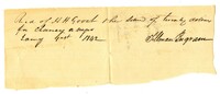
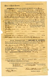
A bill of sale between James Adger and Edward Laurens for an enslaved person referenced as "negro, Pompey" for $490. The reverse side of the bill makes the notation "Bill of Sale of one negro."
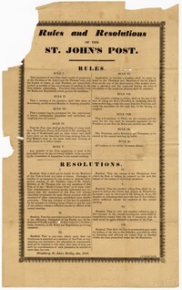
A broadside containing rules and resolutions for the St. John's Post in which members establish rules for the weekly postal service. These rules and regulations include an all-male membership, submitting applications, meetings, and resignations. Resolutions include those for behaviors with other postal organizations, resolutions for plantations and fines for failure to complete delivery of letters and papers.
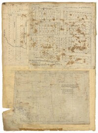
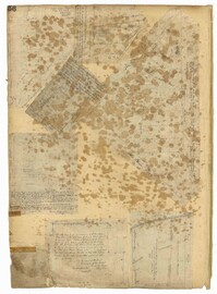
Page 32 of the City Engineer's Plat Book with three plats. Plat 1 shows lots located near the intersection of Tradd Street and Limehouse Street. Plat 2 shows lots located near Elliott Street, Broad Street, and Line Street, near the intersections with Rose Lane, Laurel Street, Percy Street, and Coming Street. Plat 3 shows lots and buildings located between St. Phillip Street and King Street, and Radcliffe Street and Warren Street.
Page 51 of the City Engineer's Plat Book with seven plats. Plat 1 shows land located between Tradd Street and the Ashley River, and labels several features of geography such as a patch of marsh and some land labelled "Hard at low water." Plat 1 also shows a lot labelled "City Lands." Plat 2 shows lots and buildings located near the intersection of Tradd Street and Savage Street. Plat 3 shows land located on the west side of New Street. Plat 4 features a lot located at the intersection of New Street and Tradd Street. Plat 5 features lots located near the intersection of New Street and Tradd Street. Plat 6 shows lots located on and near Tradd Street. Plat 7 shows structures located near the intersection of New Street and Broad Street, including a building labelled "Theatre."
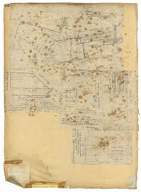
Page 49 of the City Engineer's Plat Book with six plats. Plat 1 shows land on the Cooper River. Plat 2 shows land located near Broad Street's intersections with Gadsden Street and Lynch Street, and a stream labelled "Comings Creek." Plat 3 shows wharfs and buildings along the Cooper River and near Champney Street. Plat 4 shows wharves and other structures between East Bay Street and the Cooper River. Plat 5 shows land near South Bay Street's intersections with Meeting Street and Church Street, including a lot labelled "Battery Garden" and a structure labelled "Bathing House."
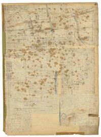
Page 42 of the City Engineer's Plat Book with five plats. Plat 1 shows land between King Street and the Ashley River, and shows bodies of water. Plat 2 shows land between Tradd Street and Payne Street, and several buildings. Plat 3 shows land and buildings on Cumberland Street, and shows two cemeteries, "Cemetery of the Circular Church," and "St Philip's Cemetery." Plat 4 shows plots near the intersection of Henrietta Street and Elizabeth Street. Plat 5 shows lots between "Marsh Street" and "Back Street."
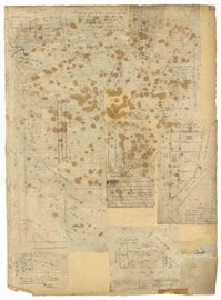
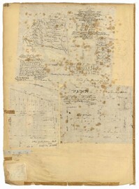
Page 36 of the City Engineer's Plat Book with three plats. Plat 1 shows land located near President Street and Rutledge Avenue, and labels certain marshlands and bodies of water. Plat 2 shows lots located near the intersection of King Street and Grove Street, near Milligan Street. Plat 3 shows land and buildings located near the intersection of Pitt Street and Bull Street.
Page 56 of the City Engineer's Plat Book with seven plats. Plat 1 shows lots between Savage Street and Tradd Street. Plat 2 shows lots and some buildings on South Bay Street. Plat 3 shows lots between Savage Street and Broad Street. Plat 4 shows a lot and several buildings at the intersection of Friend and Queen Street. Plat 5 shows land near the corner of Legare Street and Gibbes Street, and a few buildings. Plat 6 shows a lot on the west side of Friend Street. Plat 7 shows lots located between Broad Street and Tradd Street, and between Lynch Street and the Ashley River.
Compilation of original deeds, titles, and other documents related to the transfer, sale, and ownership of the double tenement at 72-74 Tradd Street, known as the Fotheringham-McNeil Tenements. Documents span from 1765 to 1961, likely representing the entire history of the ownership of the double tenement throughout that time period. Also includes blueprints and photographs. (NOTE: Fotheringham has also been spelled Fotheringham.)