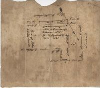
Plat contains 200 acres conveyed to Thomas McConnell of W town 1814. Granted to Duyal Mckechaw in 1735. Names associated with this plat are Thomas McConnell, Duyal Mckechaw, John Summerhoofs, Eliza Staufiur, and John White.
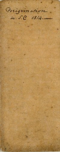
Carolus Drayton, more commonly known as Charles Drayton I (1743-1820). Details Charles Drayton's travels around South Carolina. Includes descriptions of places and buildings as well as machinery commonly found on Plantations. Includes a record of living expenses on the road, and the distances between each place. Large focus on agriculture both methods and productivity.
The Medical Account Book of Dr. George Paddon Bond Hasell contains medical entries on visits and treatments for Georgetown County plantation families and their slaves between 1812-1816. The book is written in both English and Latin and references enslaved people by their first name, the name of their slave owner or by using the letter "N" before their name.
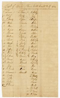
A list of enslaved men sent to work on the roads. The list is divided by occupation which includes drivers, axe men, men working with hoes and men working with spades.
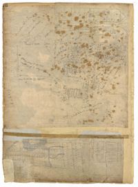
Page 76 of the City Engineer's Plat Book with three plats. Plat 1 shows land roughly between the Ashley River and Coming Street, and roughly between Elliot Street and Comings Creek. Plat 1 also shows multiple streams, marshes, and islands. It also includes Boundary Street, Doughty Street, Bee Street, Cannon Street, Smith Street, Pinckney Street, and Thomas Street. Plat 2 shows lots and some buildings located between Spring Street and a marsh, along an road labelled "Court." Plat 3 features lots located between Morris Street and Radcliffe Street, near their intersections with Pitt Street, "Commings Street," St. Philips Street, and King Street. Plat 3 also shows some marshland. Plat 4 features lots located between Smith Street and Coming Street, and between Radcliffe Street and Vanderhorst Street. Plat 4 also shows the intersection of Warren Street and Thomas Street.
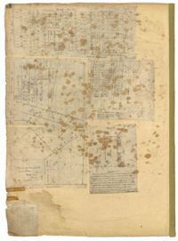
Page 66 of the City Engineer's Plat Book with fourteen plats. Plat 1 features buildings located near the intersection of King Street and Clifford Street. Plat 2 shows lots and structures located near the intersection of "Comings Street" and Wentworth Street. Plat 3 shows a lot and structures located on Pitt Street. Plat 4 shows lots located on a city block between Smith Street and Pitt Street, and between Montague Street and Wentworth Street. Plat 5 shows lots located on a city block between Montague Street and Wentworth Street, and between South Street and Rutledge Street. Plat 6 features a lot located near the intersection of "Comings Street" and Montague Street. Plat 7 shows lots and some structures located near the intersection of Bull Street and Coming Street. Plat 8 shows a lot and buildings located on Bull Street. Plat 9 Shows lots located near the intersection of Smith Street and Boundary Street. Plat 10 shows lots located on a city block between Lynch Street and Rutledge Street, and between Bull Street and Montague Street. Plat 11 shows lots and structures located near the intersection of Pitt Street and Bull Street. Plat 12 is features a lot located at the intersection of Pitt Street and Bull Street. Plat 13 Features lots located near the intersection of Bull Street and Lynch Street. Plat 14 shows lots located on Queen Street.
Page 48 of the City Engineer's Plat Book with five plats. Plat 1 shows lots located between Smith Street and King Street, and Radcliffe Street and Vanderhorst Street, including stretches of Thomas Street, Coming Street, St. Philip Street, and King Street. Plat 2 shows lots and buildings located near the intersection of King Street and South Bay Street. Plat 3 shows land near the intersection between Congress Street and Legare Street, and includes stretches of Hayne Street, Mount Street, and President Street. Plat 3 also shows some land labelled "City Land Potters Field." Plat 4 shows lots and a set of buildings located near Broad Street and Savage Street. Plat 5 shows lots and some buildings located on Gadsden Street.
Page 34 of the City Engineer's Plat Book with four plats. Plat 1 shows lots located on South Bay Street. Plat 2 shows land located between Beaufain Street and Queen Street, near Smith Street, Wilson Street, and Franklin Street. Plat 3 shows lots located near Beaufain Street's intersections with Pitt Street and Wilson Street. Plat 4 features a lot and its buildings located on Meeting Street.
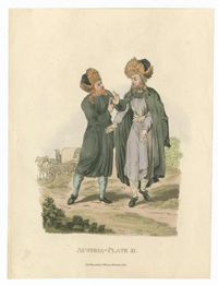
Hand-colored engraving of two Jewish men from Austria. From Picturesque representations of the dress and manners of the Austrians by William Alexander. Published London: Printed for J. Murray by W. Bulmer and co. The publication depicts the dress of people throughout areas ruled by the House of Austria (House of Habsburg). The associated plate description identifies these men as "A Polish Jew."
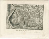
Black-and-white engraved map of Jerusalem. Engraving by John Bower. From The Holy Bible : containing the Old and New Testaments, together with the Apocrypha / translated out of the original tongues and with the former translations diligently compared and revised..., published New York: Collins and Co.
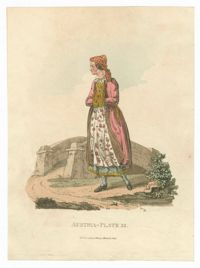
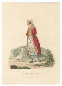
Hand-colored engraving of a Jewish woman from Austria. From Picturesque representations of the dress and manners of the Austrians by William Alexander. Published London: Printed for J. Murray by W. Bulmer and co. The publication depicts the dress of people throughout areas ruled by the House of Austria (House of Habsburg). The associated plate description identifies this woman as "A Polish Jewess."
Hand-colored engraving of a Jewish woman from Austria. From Picturesque representations of the dress and manners of the Austrians by William Alexander. Published London: Printed for J. Murray by W. Bulmer and co. The publication depicts the dress of people throughout areas ruled by the House of Austria (House of Habsburg). The associated plate description identifies this woman as "A Polish Jewess."
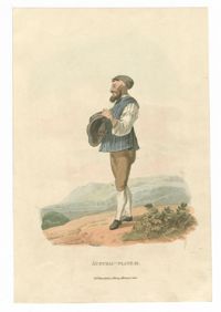
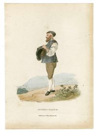
Hand-colored engraving of a Jewish man from Austria. From Picturesque representations of the dress and manners of the Austrians by William Alexander. Published London: Printed for J. Murray by W. Bulmer and co. The publication depicts the dress of people throughout areas ruled by the House of Austria (House of Habsburg). The associated plate description identifies this man as a "Jew of Montgatz, in his summer dress."
Hand-colored engraving of a Jewish man from Austria. From Picturesque representations of the dress and manners of the Austrians by William Alexander. Published London: Printed for J. Murray by W. Bulmer and co. The publication depicts the dress of people throughout areas ruled by the House of Austria (House of Habsburg). The associated plate description identifies this man as a "Jew of Montgatz, in his summer dress."