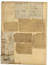
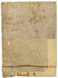
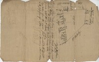
Page 106 of the City Engineer's Plat Book with ten plats. Plat 1 features a lot and its buildings located near the intersection of King Street and Tradd Street. Plat 2 features a lot and buildings located between Church Street and Water Street, near where the latter intersects with East Bay Street. Plat 3 shows lots located near the intersection of King Street and Grove Street. Plat 4 features a plat and building located on Church Street. Plat 5 features a lot located on the intersection of East Bay Street and Elliott Street. Plat 6 shows a lot located between two streets leading to wharves. Plat 7 shows lots, wharves, and docks located near the intersection of Market Street and East Bay Street. Plat 8 features a wharf and lot located near the intersection of Legare Street and South Bay Street. Plat 9 shows lots located on and near the intersection of Broad Street and East Bay Street. Plat 10 shows lots and some structures located on East Bay Street.
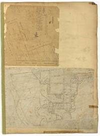
Page 151 of the City Engineer's Plat Book with two plats. Plat 1 shows lots and structures located on and near Anson Street. Plat 2 shows lots and structures located between Coming Street and the Ashley River Channel, and between Elliott Street and Mill Creek. The plat also shows 50 acres of marsh, several bodies of water, Boundary Street, Pinckney Street, Cannon Street, and President Street.
Page 256 of the City Engineer's Plat Book with four plats. Plat 1 shows land located between Elliot Street and Boundary Street, near Mill Street, Bee Street, President Street, and Doughty Street. It also shows several streams, a mill pond, and a large stretch of marsh land. Plat 2 shows a lot on Brigade Street. The third plat shows a lot and building located on the corner of Grove Street and Russell Street. The fourth plat shows lots located near the intersection of Grove Street and Tracy Street.
Page 183 of the City Engineer's Plat Book with five plats. Plat 1 shows lots located along Simons Street, between King Street and a stretch of marshland. Plat 2 shows lots on and near "Simmons" Street. It also shows lots near King Street and Romney Court. Plat 3 shows lots located near the intersection of King Street and Grove Street. Plat 4 shows lots and structures located near the intersection of Simons Street and King Street. Plat 5 shows lots along Simons Street, located between King Street and a stretch of marshland.
Page 94 of the City Engineer's Plat Book with two plats. Plat 1 shows lots and marshlands located near Meeting Street, and also shows King Street. Plat 2 features lots located between Meeting Street and a strip labelled "South Carolina R.R. Company." Plat 2 also shows Romney Street and Poinsett Street.
Page 78 of the City Engineer's Plat Book with five plats. Plat 1 features land and lots located near the Ashley River, including geographic features such as marshland, high land, and bodies of water. Plat 1 also shows Boundary Street, Hutson Street, Doughty Street, Bee Street, Elliot Street, Cannon Street, President Street, and Thomas Street. Plat 2 shows a city block between Doughty Street and Bee Street, and between President Street and Thomas Street, with some marsh labelled. Plat 3 features land and lots located near the Ashley River, with shoals and streams labelled. Plat 3 also shows Boundary Street, Pinckney Street, Cannon Street, Hutson Street, Doughty Street, and Bee Street. Plat 4 shows lots located near the intersection of Calhoun Street and Lucas Street, and shows several structures and a stretch of a creek. Plat 5 shows lots features lots located between Lucas Street and Ashley Street, and Mill Street and Doughty Street. Plat 5also shows Palmetto Street, President Street, and a lot labelled "U. S. Arsenal Square."
Page 77 of the City Engineer's Plat Book with seven plats, labelled 1 through 8 with Plat 3 missing. Plat 1 shows lots located between Smith Street and King Street, and between Morris Street and Radcliffe Street. Plat 1 also shows Coming Street and St. Philips Street, and a label reading "Bethlohim Congregation." Plat 2 shows lots and some structures near the intersection of King Street and Warren Street. Plat 4 shows lots between Smith Street and King Street, and north of Radcliffe Street. Plat 4 also shows Coming Street, St. Philips Street, Morris Street, and a lot labelled "Bethlehem Congregation." Plat 5 shows lots located near the intersection of Morris Street and St. Philips Street. Plat 6 shows lots located between Morris Street and "Hunter St now Line," and east of Coming Street. Plat 8 features a lot and structures located on the corner of St. Philips Street and Morris Street.
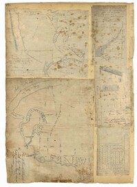
Page 63 of the City Engineer's Plat Book with five plats. Plat 1 features wharves located near East Bay Street, and shows several docks and buildings. Plat 2 shows wharfs shows a wharf and several buildings located near East Bay Street. Plat 3 features a wharf located near East Bay Street and shows multiple buildings and docks. Plat 4 features a wharf located between East Bay Street and the Cooper River channel, and also shows several buildings. Plat 5 shows lots located on and near Market Street, between East Bay and Concord Street. Plat 6 features a wharf located between East Bay Street and the Cooper River, and also shows several buildings.
Page 45 of the City Engineer's Plat Book with nine plats. Plat 1 shows lots along New Street, located between Broad Street and Tradd Street, and shows an area labelled "City marshland." Plat 2 shows lots and buildings located between Queen Street and Cliffords Alley. Plat 3 shows land located near the intersection of Washington Street and Smith Street. Plat 4 shows lots and buildings located near the intersection of Green Street and "Comming Street." Plat 5 shows land located between "Boundary (Calhoun) Street" and George Street, and St. Phillip Street and "Comming Street," including a stretch of Green Street and College Street, and a lot labelled "College Lot." Plat 6 shows a lot located on the corner of Queen Street and King Street, and its buildings. Plat 7 shows lots located on Savage Street. Plat 8 shows lots located on Beaufain Street. Plat 9 shows lots near King Street, located between Boulevard Drive and South Bay Street.
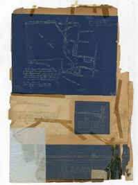
Page 47 of the City Engineer's Plat Book with four plats. Plat 1 shows lots between America Street and Meeting Street, and between Moultrie Street and Line Street. Plat 1 also includes a stretch of Moultrie Street and Hampton Street extending from Meeting Street to King Street. Plat 2 shows the plan of a wharf and channel located on East Bay Street, and includes several planned buildings and structures. Plat 3 shows lots of land located between East Bay Street and the "Edge of Channel of Cooper Street." Plat 4 shows lots located near East Bay Street's intersections with Water Street and Lynches Lane. Plat 4 shows several buildings, "Flat Broken ground," low lands, and a "Shoal dry at Low Water."
Page 49 of the City Engineer's Plat Book with six plats. Plat 1 shows land on the Cooper River. Plat 2 shows land located near Broad Street's intersections with Gadsden Street and Lynch Street, and a stream labelled "Comings Creek." Plat 3 shows wharfs and buildings along the Cooper River and near Champney Street. Plat 4 shows wharves and other structures between East Bay Street and the Cooper River. Plat 5 shows land near South Bay Street's intersections with Meeting Street and Church Street, including a lot labelled "Battery Garden" and a structure labelled "Bathing House."
Page 4 of the City Engineer's Plat Book with seven plats. Plat 1 features East Bay Street, Pinckney Street, Concord Street, and lots labelled "Burnt District." Plat 2 features lots on King Street. Plat 3 shows several lots on East Bay Street near the intersections with Pritchard Street and Hard Alley. Plat 4 shows three lots on East Bay Street. Plat 5 features lots at the intersection of East Bay Street and Hasell Street. Plat 5 shows a stretch of Queen Street including the intersections with Archdale Street and Friend Street, and includes a plat labelled "Catholic Church." Plat 7 shows plots of land on the intersection of Tradd Street and Meeting Street.
Copy of plat of 342 acres on Johns Island. Very little detail, just an outline of the property with trees on the edges. Names associated with this plat are Thomas Ladson, Hanscome, Allen, William Wallisby, Robert Murens, and Brocher. Geographic locations are the Stono River, Colleton County and Johns Island.
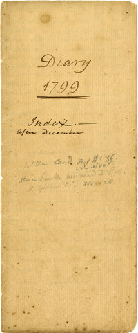
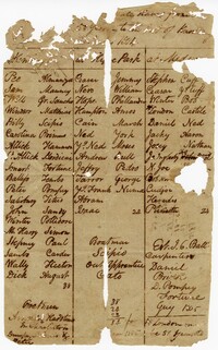
This plantation diary includes day-to-day management of Drayton plantations, (particularly Drayton Hall and Jehossee), focusing on crops, livestock, labor, and the movement of these between estates. Includes details on the unsatisfactory work of overseers, marriage of Charlotte Drayton, building of a new barn and slave houses, slave deaths from snake/spider bites and lightning strikes.
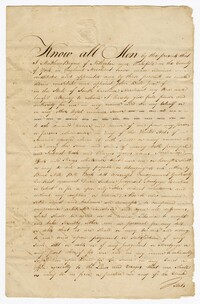
A power of attorney document stating that Matthew Bryan of Netherton in England appoints John Ball from South Carolina his attorney. Matthew Bryan outlines attorney responsibilities which includes overseeing all financial accounts in the United States.
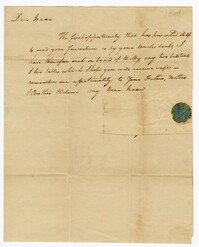
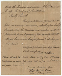
Petition of Anne Williams to the St. Andrew's Society explaining that she lives unmarried in Edinburgh and requesting that her annuity be paid. A postscript confirms that Anne Williams is alive and unmarried.
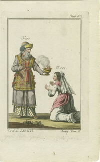
Hand-colored etching depicting the vestments of a Jewish high priest. From Tableau historique des costumes, des moeurs et des usages des principaux peuples de l'antiquité et du moyen age, Volume 2, by Robert von Spalart, published Metz: Collignon.