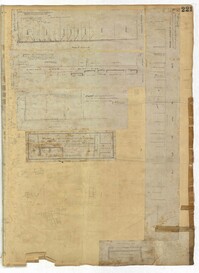
Page 221 of the City Engineer's Plat Book with six plats. Plat 1 shows lots along Payne Street, between Mount Street and Fishburne Street. Plat 2 shows lots along Lucas Street, near its intersections with Doughty Street and Mill Street, including a lot labelled "City Hospital." Plat 3 shows lots located along Kirkland Lane, between Wentworth Street and Beaufain Street. Plat 4 shows lots located near the intersection of Gadsden Street and Beaufain Street. Plat 5 shows lots located along Lightwood Alley, between Meeting Street and Church Street. Plat 6 shows a lot and building located on Cannon Street, Between Coming Street and a label reading "Church."
Page 117 of the City Engineer's Plat Book with two plats. Plat 1 shows lots located near the Cooper River. Plat 2 shows marshlands, bodies of water, and lots located near the Ashley River.
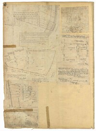
Page 53 of the City Engineer's Plat Book with five plats. Plat 1 shows shoals and marshlands located near the Ashley River Channel, Gibbes Street, and South Bay Street. Plat 2 features a lot and its buildings at the intersection of Broad Street and New Street. Plat 3 shows a lots and buildings located on Tradd Street. Plat 4 features lots and buildings located near the intersection of Broad Street and Tradd Street, including some stretches of marshland. Plat 5 shows lots located near Broad Street's and Tradd Street's intersections with New Street and Legare Street.
Page 16 of the City Engineer's Plat Book with five plats. Plat 1 shows lots close to the Ashley River located near Tradd Street and Gibbes Street, including a marsh flat labelled as "City Lands." Plat 2 shows lots located near the intersection of Tradd Street and Council Street, including "City marshlands." Plat 3 shows lots located near Gibbes Street and South Bay Street, and includes a dotted line labelled "Low Water Mark." Plat 4 shows land located between Ellery Street and Old Church Street, including a stretch of Raper Street. Plat 5 shows land near the intersection of South Bay Street and "Legare or Johnson Street," and close to the "Low Water" of the Ashley River.
This plantation diary includes day-to-day management of Drayton plantations, (particularly Drayton Hall and Jehossee), focusing on crops, livestock, labor, and the movement of these between estates. Includes details on the unsatisfactory work of overseers, marriage of Charlotte Drayton, building of a new barn and slave houses, slave deaths from snake/spider bites and lightning strikes.
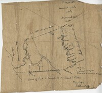
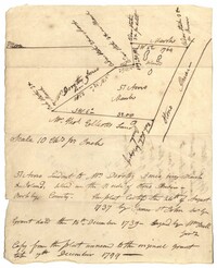
Copy of a plat of 355 Acres of land in Berkeley County near the West side of Cooper River, shows surrounding properties, doesn’t include land type or detailed notations. Names associated with this plat are Edward Keating, William Kimlough, Buvet, Matthew Beard, Colonel Chicken, Chapennoun Elliott, Robert Daniell, Longrove Thomas, Edward Keyting, Andrew Allens, William Gibbons, James Kenloch, William Adams, Allen Anderson, William Gibbons, Matthew Benson, Thomas Smith, John Vecandge [?], Francis Ternandol, and Allen Andrew. Notable geographic locations include St. James Parish, Goose Creek, Cooper River, and Berkeley County.
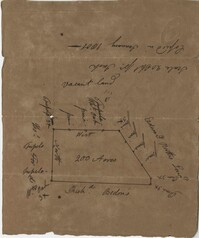
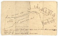
Copy of a plat of 200 acres in St. George’s Parish. The property lines and various trees located on them are the only details included. Names associated with this plat are G. Wagner, Samuel Jones, Thomas Hotkins, Francis Yonge, and Robert Daniell. Notable geographic locations include the Stono River and Berkeley County.
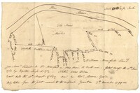
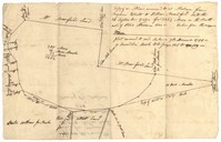
Plat of 300 acres in St. Andrew’s Parish on the Stono River originally granted to William Branford. At the time of the copy it belonged to George Wagner. Names associated with this plat are William Branford, George Wagner, Egerton Leigh, Thomas Boone and Elizabeth Hutchins.
Plat of 57 acres belonging to Dorothy Jones on the Stono River. At the time of the copy belonged to George Wagner. Names associated with this plat are Dorothy Jones, George Wagner, Bull and John St. James.
Copy of a plat of land in St. Andrew’s Parish, 103 acres are marsh land. Little other detail or explanation. At the time of the copy belonged to George Wagner. Names associated with this plat include Stephen Bull, Thomas Jones, George Wagner, Richard Godfrey, Nathaniel Brown and Thomas Jones.
Plat of land annexed to a release from Benjamin Elliott to William Brandford for 362.5 acres. At the time of the copy belonged to George Wagner. Names associated with this plat include William Branford, Benjamin Elliott, Wagner George and Thomas Elliott.
This document is a court case discussing a law suit to recover wages brought by Lydia Witten, a midwife who delivered the child of a slave women (referenced as "negro woman") without the consent of her master.
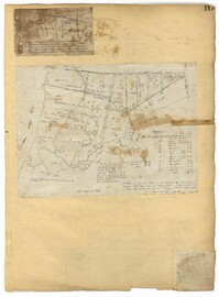
Page 12 of the City Engineer's Plat Book with two plats. Plat 1 shows plots near Coming Street, St. Phillip Street, King Street, Meeting Street, and Vanderhorst Street. Plat 2 Shows lots on Queen Street near the intersections with East Bay Street and Prioleau Street, has the label "Charleston Harbour Cooper River" on the right-hand margin.
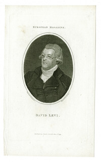
Black-and-white engraved portrait of Hebraist and author David Levi. Engraving by William Bromley after Samuel Drummond. Published in the European Magazine.
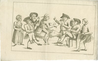
Black-and-white etched satire on attitudes toward vaccination. Edward Jenner, pioneer of the smallpox vaccine, is portrayed as a Jew. He holds a syringe labelled "Kuhpocken" (cowpox) and "Humanität" (humanity). Next to him sits a Jewish elder who has one foot on a money bag. Another Jew reads from a document labeled "Für Die Juden" (for the Jews), handed to him on a cushion embroidered with a Star of David by a non-Jewish man astride a sow. He is followed by a rabbi praying and another Jew. At left, a non-Jewish woman holds the sow's rope in one hand and, in the other, a paper labeled "Freiden Mädchen - Berliner Blätter" (prostitute - Berlin Gazette). The etching indicates that the publication of Jenner's work is a Jewish conspiracy.