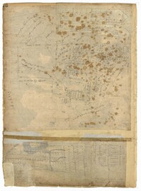
Page 76 of the City Engineer's Plat Book with three plats. Plat 1 shows land roughly between the Ashley River and Coming Street, and roughly between Elliot Street and Comings Creek. Plat 1 also shows multiple streams, marshes, and islands. It also includes Boundary Street, Doughty Street, Bee Street, Cannon Street, Smith Street, Pinckney Street, and Thomas Street. Plat 2 shows lots and some buildings located between Spring Street and a marsh, along an road labelled "Court." Plat 3 features lots located between Morris Street and Radcliffe Street, near their intersections with Pitt Street, "Commings Street," St. Philips Street, and King Street. Plat 3 also shows some marshland. Plat 4 features lots located between Smith Street and Coming Street, and between Radcliffe Street and Vanderhorst Street. Plat 4 also shows the intersection of Warren Street and Thomas Street.
Page 66 of the City Engineer's Plat Book with fourteen plats. Plat 1 features buildings located near the intersection of King Street and Clifford Street. Plat 2 shows lots and structures located near the intersection of "Comings Street" and Wentworth Street. Plat 3 shows a lot and structures located on Pitt Street. Plat 4 shows lots located on a city block between Smith Street and Pitt Street, and between Montague Street and Wentworth Street. Plat 5 shows lots located on a city block between Montague Street and Wentworth Street, and between South Street and Rutledge Street. Plat 6 features a lot located near the intersection of "Comings Street" and Montague Street. Plat 7 shows lots and some structures located near the intersection of Bull Street and Coming Street. Plat 8 shows a lot and buildings located on Bull Street. Plat 9 Shows lots located near the intersection of Smith Street and Boundary Street. Plat 10 shows lots located on a city block between Lynch Street and Rutledge Street, and between Bull Street and Montague Street. Plat 11 shows lots and structures located near the intersection of Pitt Street and Bull Street. Plat 12 is features a lot located at the intersection of Pitt Street and Bull Street. Plat 13 Features lots located near the intersection of Bull Street and Lynch Street. Plat 14 shows lots located on Queen Street.
Page 47 of the City Engineer's Plat Book with four plats. Plat 1 shows lots between America Street and Meeting Street, and between Moultrie Street and Line Street. Plat 1 also includes a stretch of Moultrie Street and Hampton Street extending from Meeting Street to King Street. Plat 2 shows the plan of a wharf and channel located on East Bay Street, and includes several planned buildings and structures. Plat 3 shows lots of land located between East Bay Street and the "Edge of Channel of Cooper Street." Plat 4 shows lots located near East Bay Street's intersections with Water Street and Lynches Lane. Plat 4 shows several buildings, "Flat Broken ground," low lands, and a "Shoal dry at Low Water."
Plat of land which includes a marsh and creeks, very little other detail. Names associated with this plat are Purcell, Thomas Rose, John Blade, and E. Rivers. Notable geographic locations include Tiger Swamp.
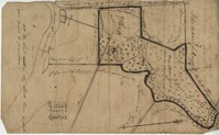
Plat of 237 acres belonging to Rob Reeves Gibbes. Detailed marsh and high land along with the location and outline of a house. Names associated with this plat are Robert Reeve Gibbes, Nathaniel Heyward, John Gibbes, Thomas Gibbes, and Lewis Gibbes. Notable geographic locations include the Combahee River, Tupelo Swamp, and Charleston District.
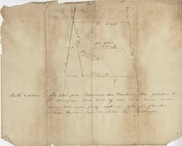
Sketch of the survey ad laying out of a small tract called Red Branch on the west side of the Cooper River containing 6 acres lately sold by Middleton to Leval part of 400 acres tract granted to Dr. Snow. Names associated with this plat are Peter Pamplat, Peter Gray, Snow, and Middleton.
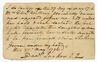
A legal claim written by Daniel Tucker for a woman named Mrs. Withers certifying that Charlotte, the daughter of Mary Ball, formerly her indentured servant, is free from all claims.
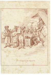
Satirical scene etched in red depicting four members of the committee around a treasure chest, which is empty of coins and occupied by a grinning demon. The Secretary holds upside down an empty bag inscribed "ils ont emigrè" ("they have emigrated"). One of the committee members takes from a Jew (at left) a dish on which a little demon is excreting coins. On the right, a large cupboard with packages labeled Recepissen (receipts) and Assignats (paper money issued during the French Revolution) falls forward on to the backs of two committee members, including the president of the Committee of Accounts. The Jew sells a figure which he assures the purchaser will, if nourished with the tears of the Orangists, give fifty ducats daily. This is better than the piles of assignats which threaten ruin. Territories conquered by France during the Revolution were forced to take assignats from French soldiers and to change them for receipts. Etching by William Humphrey after a caricature by David Hess. From Hollandia regenerata by David Hess.
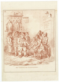
Satirical scene etched in red depicting the patriots, who had emigrated in 1787 after their defeat by the Anglo-Prussian alliance, approaching the committee, apparently two French Représentants en Mission, with requests for money and clothes. Four men stand on the right, two with papers inscribed "Request." From the pocket of one (right), dressed as a soldier, projects a carriage-lamp, which he is alleged to have stolen. One Frenchman, wearing a scarf inscribed "Representant," and holding a pair of breeches, puts money into an outstretched palm. On the left, an old Jew measures a patriot wearing sabots (clogs) for a suit of clothes. Behind him is a wall from which projects a sign: "Nathan Levi Uitdraager en Kleermaaker" ("broker and tailor"). Etching by William Humphrey after a caricature by David Hess. From Hollandia regenerata by David Hess.