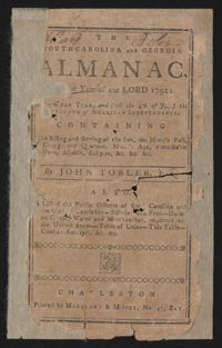
This is a Sandy Island plantation journal written inside of The South Carolina and Georgia Almanac for the year 1792. The plantation journal documents the planting of crops (rice, corns, and potatoes), the maintenance of ditches and drains, slave records, complications with the hiring of an overseer, livestock, and business relations with Laurel Hill Plantation.
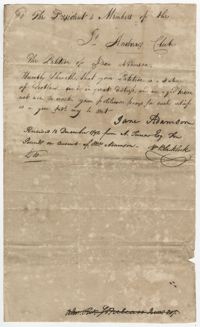
Petition of Jane Adamson to the St. Andrew's Society requesting assistance, explaining that she is unable to work. A postscript notes that the society gave Jane Adamson ten pounds.
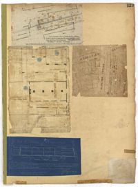
Page 127 of the City Engineer's Plat Book with four plats. Plat 1 shows lots and wharves, including Accommodation Wharf and Brown's Wharf. Plat 2 shows structures on Anson Street. Plat 3 shows lots located near the intersection of Pinckney Street and Anson Street. Plat 4 shows lots located on and near Gadsden Street, between Pinckney Street and King Street.
Page 69 of the City Engineer's Plat Book with eight plats. Plat 1 shows land located on either side of Burns Lane, and also shows George Street. Plat 2 features a lot and some buildings on George Street. Plat 3 features lots located on and near King Street, between Beaufain Street and Lynch Street. Plat 4 shows a city block located between Beaufain Street and Wentworth Street, and between Pitt Street and Kirkland Lane. Plat 5 shows lots and some buildings located near the intersection of Smith Street and Montague Street. Plat 6 shows lots on Coming Street, between Montague Street and Wentworth Street. Plat 8 shows lots and some buildings located on Pitt Street, including a lot labelled "The Brown Fellowship Society Cemetery."