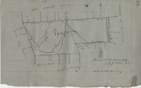
876 acres of land west of Murray Road in St. John's Parish. Names associated with this plat are Chas Johnston, Ben Castell, William Simpson, Verth, and J.G. Wiare. Notable geographic locations include Wadboo Barony.
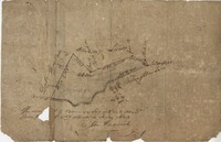
Plat of land of 64 acres laid out for Allard Belin situated on Sandy Island. Names associated with this plat are Allard Berlin, John Hardwick and D.T. Waring.
Page 178 of the City Engineer's Plat Book with five plats. Plat 1 shows lots and structures located on and near King Street, near the intersection with "Shepheard" Street. Plat 2 shows lots located on and near Spring Street, King Street, and Meeting Street. Plat 3 shows lots and a building located near the intersection of King Street and Sheppard Street. Plat 4 shows lots located on a city block between Cooper Street and Lee Street, and between Aiken Street and America Street. One lot is labelled "Baptist Church Lot." Plat 5 shows Cooper Street, Aiken Street, Lee Street, and America Street.
Page 50 of the City Engineer's Plat Book with seven plats. Plat 1 shows wharves and other structures located on East Bay Street. Plat 2 shows lots and buildings located on the intersection of Tradd Street and Meeting Street. Plat 3 shows lots located near the intersection of Broad Street and Rutledge Street. Plat 4 shows lots and buildings located near Gibbes Street. Plat 5 shows lots located near the intersection of Society Street and East Bay Street. Plat 6 shows lots and buildings near Broad Street. Plat 7 shows lots located between South Bay Street and the Ashley River, near Legare Street.
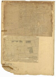
Page 8 of the City Engineer's Plat Book with two plats. Plat 1 shows plots near "Village Hampstead Public Square" and shows numerous streets including King Street, Columbus Street, and Meeting Street. Plat 2 shows lots near the intersection of Radcliffe Street and King Street, including a lot labelled "Estate of McIntosh."