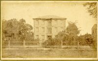
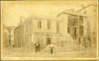
Caption: 'Cook's Earthquake Views of Charleston and Vicinity. Taken after the 31st of August, 1886. No. 55, Major R.C. Gilchrist, Bee St[reet].' Charleston city directory for 1886 shows Robert C. Gilchrist at 12 Bee Street.
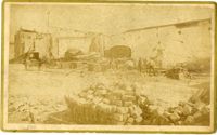
Caption: 'Cook's Earthquake Views of Charleston and Vicinity. Series No.2. No.190, Kerr's Wharf. Charleston city directory for 1886 lists Kerr's Wharf as opposite Cordes.
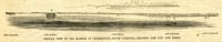
Caption: 'Profile view of the harbor of Charleston, South Carolina, showing the city and forts.' Identified in the image: Fort Johnston (sic), Fort Sumter, Charleston, Fort Moultrie and Mount Pleasant. [full date December 29, 1860.]
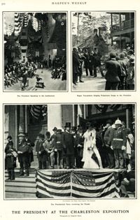
Main caption: 'The President at the Charleston Exposition. Photographs by Frederick Moore.' Caption top left: 'The President speaking in the auditorium.' Caption top right: 'Negro tea-pickers singing pickaninny songs to the President.' Caption bottom center: 'The presidential party reviewing the parade.' Further captioning identifies: 'The President, Sec. Wilson, Mayor Smythe, Mrs. Roosevelt.'
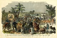
[Color image.] Caption: 'The citizens of Charleston, S.C., deserting their homes, on the threatened attack of the city by the Federal Forces. From a Sketch by Lieutenant G.P. Kirby.'
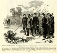
Caption: 'Escorting Major Taylor, of New Orleans, the bearer of a flag of truce, blindfolded, to the Confederate lines, after his unsuccessful mission.'
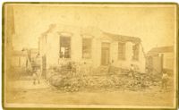
Caption: 'Cook's Earthqauke Views of Charleston and Vicinity. Taken after the 31st of August, 1886. No.126, East Bay, corner Queen Street.' Sign on building reads: 'Ship & Family Groceries.' Possibly J.J.W. Luden, retail grocers and ship chandlers, located 167-169 East Bay, according to the 1886 Charleston city directory.
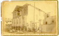
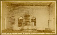
Caption: Cook's Earthquake View of Charleston and Vicinity. Taken after the 31st of August, 1886. No.151, Mariner's Church, interior.' Also, handwritten at bottom, front: 'Charleston Earthquake scene - Interior of Mariners' Church, on Church Street.'