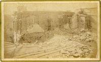
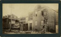
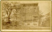
Caption: 'Cook's Earthquake Views of Charleston and Vicinity. Taken after the 31st of August, 1886. No.135, Corner State and Chalmers Streets.' Written on front, at bottom: 'Charleston Earthquake views - ruins cor[ner] Chalmers & State Str.'
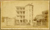
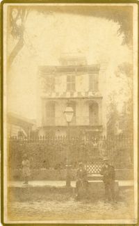
Caption: 'Cook's Earthquake Views of Charleston and Vicinity. Series No.2. No.187, residence of Mr. A. Lengnick.' Charleston city directory for 1886 shows Albert Lengnick at 11 Pitt Street.
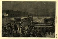
Caption: 'The Siege of Charleston--the morning call to the Rebels.--sketched from the naval battery by Mr. Theodore R. Davis.--[see page 603.]' [full date September 19, 1863.]
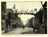
Caption: 'Charleston--Celebration of her recovery from the effects of the Earthquake.--from a photograph by Cook.--[see page 818.]' [full date November 12, 1887.]
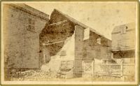
Caption: 'Cook's Earthquake Views of Charleston and Vicinity. Series No.2. No.167, rear of residence of Geo. [George] W. Williams, Jr.' Charleston city directory for 1886 shows George W. Williams, Jr. at 2 Atlantic Street.
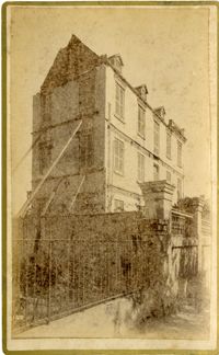
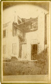
Caption: 'Cook's Earthquake Views of Charleston and Vicinity. Series No.2. No.182, Porch of Lazarus House.' Hassell Street. Charleston city directory for 1886 shows Mrs. B.D. Lazarus at 64 Hassell Street.
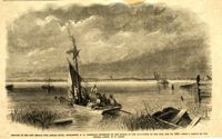
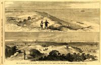
Caption: 'The advance upon Charleston--entrance to the Stono River, S.C.--from a sketch by Lieut. Coleman, 100th N.Y.S. Vol.' Also identified with captions: 'Kiawah Island and River. John's Island. Stono River. Cole's Island. Old Rebel Fort.' [full date April 25, 1863.]
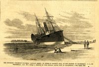
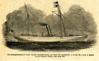
Caption: 'The Southern steamship Columbia. Captain Berry, on shore in Maffit's Bay, in the harbor of Charleston, S.C., on Wednesday, Jan. 23.--from a sketch by our Special Artist in Charleston.--see page 194.' [full date February 16, 1861.]
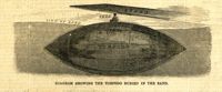
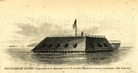
Caption: 'The Floating Battery, now erecting in the harbor of Charleston by the authorities of South Carolina. Designed to capture Fort Sumter.--from a sketch by our Special Artist now in Charleston. See page 194.' [full date February 16, 1861.]
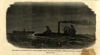
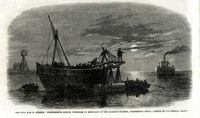
Caption: 'The Anglo-Confederate prize steamer Princess Royal captured off Charleston, January 29.--from a sketch by our Special Artist.--see page 366.' [full date February 28, 1863.]
Caption: 'The Civil War in America: the Federal ironclad Keokuk as she appeared on the morning after the fight.--from a sketch by our Special Artist.--see page 542.' [full date May 16. 1863.]
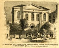
Caption: 'St. Andrew's Hall, Charleston, head-quarters of the Wood Delegation at Charleston.--[from a sketch by our own artist.]' [full date May 5, 1860.]
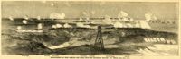
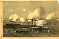
Caption: 'Bombardment of Fort Sumter--The fleet engaging Batteries Wagner and Gregg.--[See Page 587]' Identified by captions are the Swamp Angel, Fort Johnson, Fort Sumter, Fort Gregg, Battery Wagner and iron-clads. [full date September 12, 1863.]
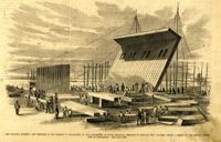
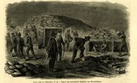
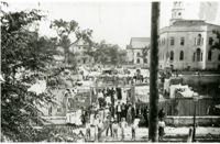
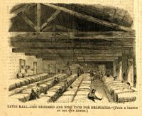
Caption (in German): 'Belagerung von Charleston, S.C.--Bauen von bombenfesten Gewoelben auf Morris Island.' {Siege of Charleston, S.C.--Building of bombproof bunkers on Morris Island.}
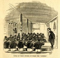
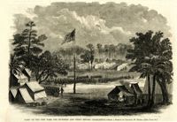
Caption: 'Port Royal Island--1. Camp Saxton (Smith's Plantation)--the new headquarters of the 1st S.C. Vol. (Colored), Col. Higginson. 2. Mitchellville, the new south village for Contrabands, Hilton Head.--from sketches by our Special Artist.--see page 317.' [full date February 7, 1863.]
Caption: 'The War in Virginia--railroad bridges over the Rappahannock, at Rappahannock Station.--from a sketch by our Special Artist, Edwin Forbes.' [full date October 31, 1863.]
Caption: 'Eastport, Mississippi, General Thomas's head-quarters, January, 1865.--sketched by Adam Rohe.--[see page 110.] [full date February 18. 1865.]
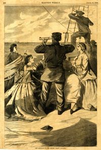
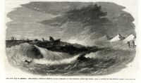
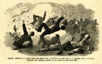
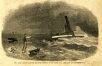
Caption: 'Terrified effects of a shell from a Rebel ram, bursting on board the U.S. gunboat Keystone State, January 31.--from a sketch by an Officer.--see page 365.' [full date February 28, 1863.]
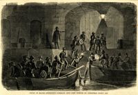
Caption: 'The siege of Charleston--the "Segar Steamer" which propelled the Rebel torpedo.--sketched by an occasional contributor. [see page 695.]' [full date October 31, 1863.]
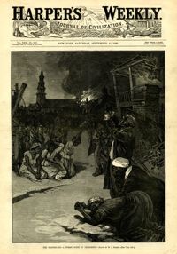
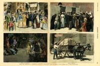
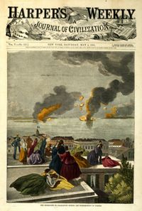
[Color image.] Main caption: 'After the Earthquake at Charleston.--drawn by W.A. Rogers and W.P. Snyder from sketches by Frederic Remington and A.J. Gustin.--[see page 610.]' Caption upper left: 'Open air preaching.' Caption upper right: 'Subsistence Committee.' Caption lower left: 'Negro prayer-meeting.' Caption lower right: 'Relief committee.' [full date September 18, 1886.]
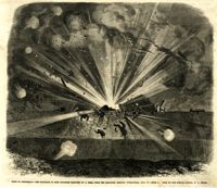
Caption: 'Siege of Charleston--the magazine of Fort Moultrie exploded by a shell from the grounded monitor Weehawken, Sept. 8.--from a sketch by our own Special Artist, W.T. Crane.' [full date October 3, 1863.]
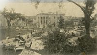
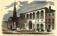
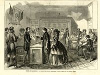
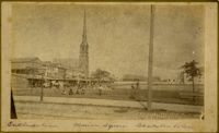
Caption: 'The Charleston Convention--view of the South Carolina Institute building, in Meeting Street, Charleston, S.C., where the Democratic Convention will hold its meeting during the present month of April.--from a sketch by our Special Artist.--see page 804.' [full date April 14, 1860.]
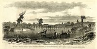
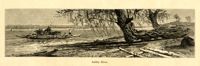
Caption: 'Remains of the new bridge over Ashley River, Charleston, S.C., partially destroyed by the Rebels on the evacuation of the city, Feb 18, 1865.--from a sketch by our Special Artist, W.T. Crane.' [full date June 10, 1865.]
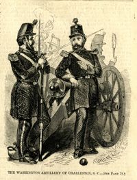
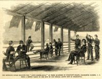
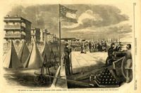
Caption: 'The Richland Rifles enjoying the "after-dinner hour," at their quarters on Sullivan's Island, Charleston Harbor, S.C. From a sketch taken on the spot by our Special Artist now in Charleston.' [full date March 2, 1861.]
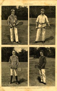
Main caption: 'Leading lawn-tennis players.--photographed by E.M. Bidwell.--[see page 583.]' Caption top left: 'Richard Dudley Sears.' Caption top right: 'Dr. James Dwight.' Caption bottom left: 'R. Livingston Beeckman.' Caption bottom right: 'Howard A. Taylor.' [full date September 11, 1886.]
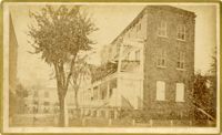
Caption: 'Cook's Earthquake Views of Charleston and Vicinity. Taken after the 31st of August, 1886. No.65, _____ Holmes, East Battery.' Written on front, at bottom: 'Charleston Earthquake scene - Holmes residence, East Battery.' Charleston city directory for 1886 shows Charles R. Holmes, Jr., at 19 East Battery.
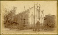
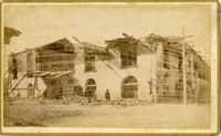
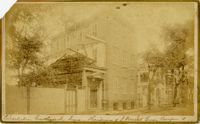
Charleston Earthquake scene. Possibly from Cook's Earthquake Views. Series No.2. No.169, College of Charleston, front [captioning missing, 'Cook No.169' handwritten on reverse].
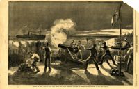
Caption: 'The Civil War in America: Confederates sinking torpedoes by moonlight in the harbour channel, Charleston.--from a sketch by our Special Artist.' [full date May 16, 1863.]
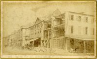
Caption: 'Cook's Earthquake Views of Charleston and Vicinity. Series No.2. No.154, East Bay, 60 days after the earthquake.' Written on front, at bottom: 'View on East Bay 60 days after the Earthquake.' Sign on building reads: 'Otto Tiedman & Sons.' Charleston city directory for 1886 shows business at 172-174 East Bay.
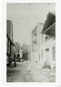
Caption: 'Cook's Earthquake Views of Charleston and Vicinity. Series No.2. No.159, Storehouses Adger's Wharf.' Charleston city directory for 1886 lists Adger's Wharf as opposite Tradd Street on East Bay.
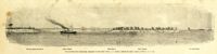
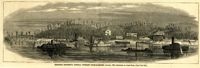
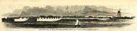
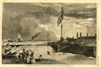
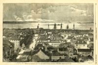
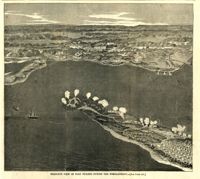
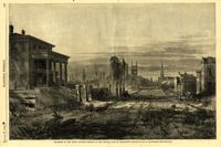
Caption: 'The city of Charleston, South Carolina, looking seaward, and showing the burned district.--[see next page.]' Identified in image are: Broad Street, "Mercury" office, Custom-house, Castle Pinckney, Fort Moultrie, Fort Sumter and Morris Island. [full date December 28, 1861.]
Caption: 'Firing on the "Star of the West" from the South Carolina battery on Morris Island, January 10, 1861.--[see page 54.]' [full date January 26, 1861]
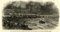
Caption: 'Flood on the Susquehanna River at Harrisburg--Accumulation of timber and driftwood at the Cumberland Valley Railroad Bridge.' [full date April 15, 1865]
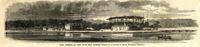
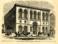
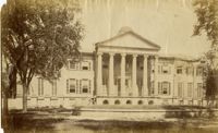
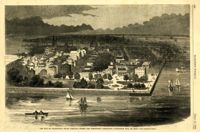
[Color image]. Caption: 'The South Carolina Institute, at Charleston, South Carolina, in which the Democratic Convention will meet.--[see preceding page.]' [full date April 21, 1860.]
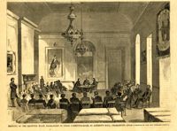
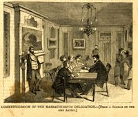
Caption: 'Meeting of the rejected Wood delegation in their committee-room, St. Andrew's Hall, Charleston.--[from a sketch by our own correspondent.] [full date May 5, 1860.]
Caption: 'Siege of Charleston--views of the Northern and Southern ends of Morris Island, as seen from Fort Craig.--from sketches by our Special Artist, W.T. Crane.' Caption at top: 'North end of Morris Island.' Caption at bottom: 'South end of Morris Island.' [full date August 29, 1863.]
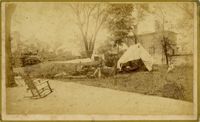
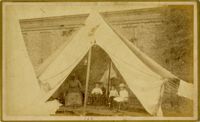
Caption: 'Cook's Earthquake Views of Charleston and Vicinity. Taken after the 31st of August, 1886. No.100, a family tent.' Image of an African-American nanny with three children.
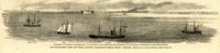
Caption: 'Our blockading fleet off North Channel, Charleston Harbor, South Carolina.--sketched by a Naval Officer.--[see page 79.] References--A. Fort Sumter.--B. Charleston City.--C. Fort Moultrie.--D. Rebel tug at work on the obstructions.--E. Obstructions.--F. Fort Johnson.--G. Mount Pleasant Batteries.' Also identified in image: South Carolina, Blunt, Daylight and Stars and Stripes (ships of the fleet). [full date January 31, 1863.]
Caption: 'Middle-ground Battery, Charleston, S.C.--sketched by A.P. Palmer, 21st South Carolina Volunteers.--[see page 70.]' [full date January 31, 1863.]
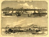
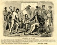
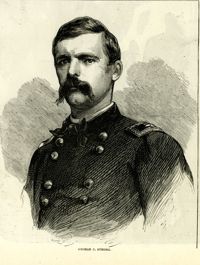
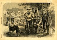
Caption: 'Colonel William Wilson and his staff (Wilson's Fighting Brigade)--[see page 311].' Identified in image: Quartermaster Bradley, Lieutenant Colonel Creighton, Adjutant James J. Hearey, Paymaster Peter Duffy, Col. William Wilson, Surgeon D.C. Pease and Major William Newby. [full date May 18, 1861.]
Caption: 'Reinforcement of Fort Pickens by Company A, First Artillery, on Saturday morning, April 13--Sketched by an Engineer Officer of the "Brooklyn."--[See Next Page].' [full date May 18,1861.]
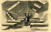
Caption (in German): 'Das Innere des Hospitals der schwimmenden Batterie im hafen von Charleston.' {Interior of the hospital of the Floating Battery in Charleston Harbor}
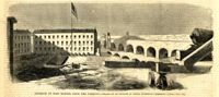
Caption: 'The Battery or Park Promenade at Charleston, South Carolina, during the bombardment of Fort Sumter--Sketched by our Special Artist--[see next page].' [full date May 18, 1861.]
Caption: 'Morris Island, as seen from Fort Sumter.--[drawn by an Officer of Major Anderson's Command.]' Also identified with captions: 'Battery from which the "Star of the West" was fired upon. Cumming's Point. Sand Battery, connected by covered gallery with...iron-clad battery.' [full date March 2, 1861.]
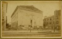
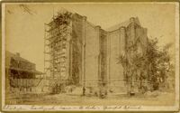
Caption: 'Cook's Earthquake Views of Charleston and Vicinity. Taken after the 31st of August, 1886.' Possibly No.178, but corresponding captioning is missing. Handwritten on reverse: 'Formerly St. Luke's Episcopal now [New Tabernacle] Fourth Baptist Church, 22 Elizabeth Street.' Handwritten at bottom, front: 'Charleston Earthquake scene - St. Luke's Episcopal Church.'
Caption: 'Quarters of the Union officers exposed to the Federal fire in Charleston.--sketched by one of the Officers.--[see page 550.]' [full date August 27, 1864.]
Caption: 'The city of Charleston, South Carolina, where the Democratic Nominating Convention will be held.--[see preceding page.]' [full date April 21, 1860.]