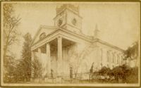
Caption: 'Cook's Earthquake Views of Charleston and Vicinity. Taken after the 31st of August, 1886. No. 17, St. Paul's Church.' St. Luke and St. Paul's Episcopal Cathedral, Coming Street.
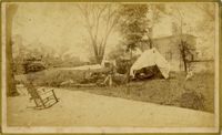
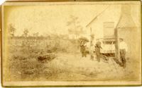
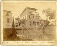
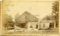
Caption: 'Charleston Earthquake. Photographs by Dr. E.P. Howland, taken on his visit to Charleston and the earthquake region of Ten Mile Hill and Summervile. Over 150 Photographs were taken. House of Mrs. Snowden, President of Confederate Home.'
Caption: 'Cook's Earthquake Views of Charleston and Vicinity taken after the 31st of August, 1886. No.2, St. Michael's Church, Interior.' Handwritten along bottom: 'Charleston Earthquake scene - interior of St. Michael's Church.' Very similar to MK 4133.
Caption: 'Cook's Earthquake Views of Charleston and Vicinity. Taken after the 31st of August, 1886. No.150, Mariner's Church, exterior." Also, handwritten at bottom of image: 'Charleston Earthquake scene - Mariners' Church, Church Street ? East Bay'
Caption: Cook's Earthquake View of Charleston and Vicinity. Taken after the 31st of August, 1886. No.151, Mariner's Church, interior.' Also, handwritten at bottom, front: 'Charleston Earthquake scene - Interior of Mariners' Church, on Church Street.'
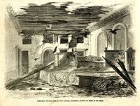
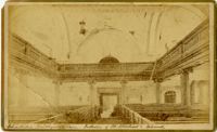
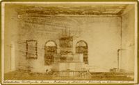
Caption: 'Cook's Earthquake Views of Charleston and Vicinity, Series No.2. No.153, Main aisle of St. Michael's Church, showing fissures and upheavals.'
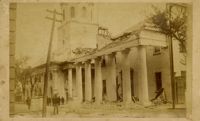
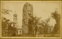
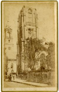
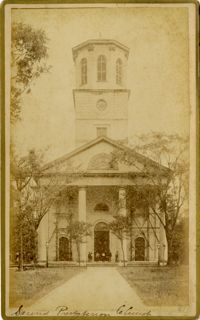
Caption: 'Cook's Earthquake Views of Charleston and Vicinity. Taken after the 31st of August, 1886. No.81, Flinn's Church.' Handwritten notation next to it and at bottom, front: '2nd Presbyterian Church.'
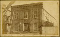
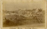
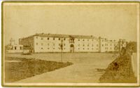
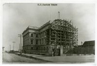
Caption: 'Cook's Earthquake Views of Charleston and Vicinity. Taken after the 31st of August, 1886. No.12, Citadel Academy.' Shows Citadel when located on Marion Square.
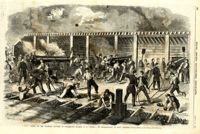
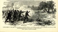
Caption: 'A detachment of the First South Carolina (Colored) Federal Volunteers, Colonel Beard, repelling an attack of the Confederate troops in the vicinity of Doboy River, Ga. From a sketch by Colonel Brewerton.'
[Color image.] Caption: 'The citizens of Charleston, S.C., deserting their homes, on the threatened attack of the city by the Federal Forces. From a Sketch by Lieutenant G.P. Kirby.'
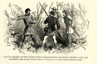
Caption: 'Captain Frazer, of the Twenty-First Massachusetts Regiment, turning upon and capturing his guard while being conveyed to the Confederate camp.'
Caption: 'Cook's Earthquake Views of Charleston and Vicinity. Taken after the 31st of August, 1886. No.46, Club House, Otranto, rear.' Written on front, at bottom: 'Charleston Earthquake scene - fallen wall, Otranto Club House.'
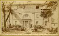
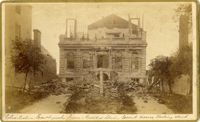
Caption: 'Cook's Earthquake Views of Charleston and Vicinity. Taken after the 31st of August, 1886. No.5, Medical College.' Handwritten at bottom, front: 'Charleston Earthquake scene - Charleston Medical College. Queen Street.'
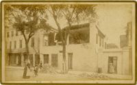
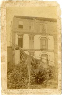
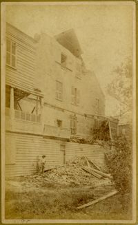
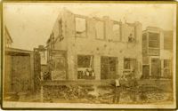
Written on reverse: 'House in which young Mr. Robson was killed. Two young ladies were buried in the ruins were rescued. Coming near Cannon.' Possibly from Cook's Earthquake Views, No.132, residence of J.N. Robson, from west. Written on front, at bottom: 'Charleston Earthquake view. Residence of Mr. J.N. Robson, whose eldest son was killed.' Charleston city directory for 1886 shows James N. Robson at 200 Coming Street.
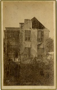
Caption: 'Cook's Earthquake Views of Charleston and Vicinity. Taken after the 31st of August, 1886. No.131, residence J.N. Robson, south side.' Charleston city directory for 1886 shows James N. Robson at 200 Coming Street.
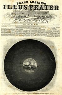
Caption: 'Bombardment of Fort Sumter, as sketched from Morris Island, Charleston Harbor, S.C.' Identified in image: Mortar Battery, Fort Johnson; James Island; City; Castle Pinckney; Fort Sumter; Mount Pleasant; Floating Battery; Mortar Battery; Fort Moultrie; Enfilading Battery; Iron Battery; Sand-bag cover for reserve; Traverse behind Trapier Battery and Magazine covered with sand bags.
Caption: 'Battle of Bull Run, July 21st, 1861--Grand "Skedaddle" of the Federal troops under General McDowell, and of the citizens of Washington who came down to witness the battle.'
Caption: 'Cook's Earthquake Views of Charleston and Vicinity. Taken after the 31st of August, 1886. No.8, U.S. Court House.' Written on bottom, at front: 'Charleston Earthquake scene - United States Court House, Meeting Street.'
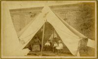
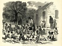
Caption: 'Cook's Earthquake Views of Charleston and Vicinity. Taken after the 31st of August, 1886. No.100, a family tent.' Image of an African-American nanny with three children.
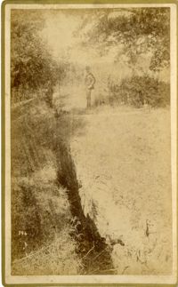
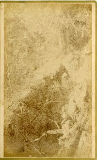
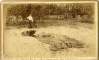
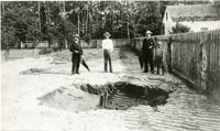
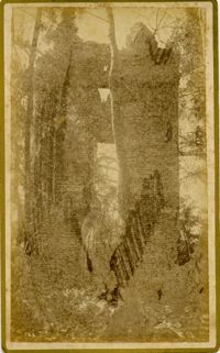
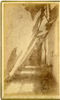
Caption: 'Cook's Earthquake Views of Charleston and Vicinity. Taken after the 31st of August, 1886. No.51, Wide fissure, Ten Mile Hill.' Handwritten at bottom, front: 'Charleston Earthquake scene - Large geyser near Ten Mile Hill.'
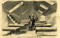
Caption (in German): 'Das Innere des Hospitals der schwimmenden Batterie im hafen von Charleston.' {Interior of the hospital of the Floating Battery in Charleston Harbor}
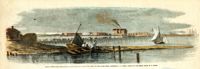
Caption: 'Remains of the new bridge over Ashley River, Charleston, S.C., partially destroyed by the Rebels on the evacuation of the city, Feb 18, 1865.--from a sketch by our Special Artist, W.T. Crane.' [full date June 10, 1865.]
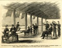
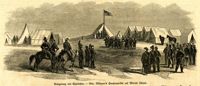
Caption: 'The Richland Rifles enjoying the "after-dinner hour," at their quarters on Sullivan's Island, Charleston Harbor, S.C. From a sketch taken on the spot by our Special Artist now in Charleston.' [full date March 2, 1861.]
Caption: 'Siege of Charleston--1.Bombardment of Fort Moultrie and the Batteries Bee and Beauregard, by the monitors and ironsides, Sept. 7th and 8th.--2. Interior of Battery Gregg, looking towards Wagner. From sketches by our Special Artist, W.T. Crane.' [full date October 3, 1863.]
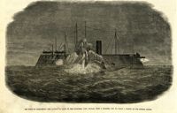
Caption: 'Night after the fight--the iron clads at anchor off Fort Sumter.--sketched by our Special Artist, Mr. W.T. Crane.--see page 81.' [full date May 2, 1863.]
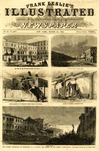
Main caption: 'The present appearance of Charleston, S.C., showing the effects of the Federal bombardment.--from recent sketches by our special artist.' Caption top left: 'Nos.165, 167 and 169 Meeting Street, Charleston, S.C.' Caption top right: 'East Bay Street, looking south.' Caption middle left: 'Kitchen attached to 53 Wentworth Street--effect of two shells.' Caption middle right: 'Gentleman's ordinary, Charleston Hotel.' Caption bottom: 'Vendue Range.' [full date March 25, 1865.]
Caption: 'Scene on the Floating Battery in Charleston Harbor, S.C., during the bombardment of Fort Sumpter (sic).--from a sketch by an Officer.--see page 355.' [full date April 27, 1861.]
Caption (in German): 'Die im Ban [Bau] begriffene schwimmende Batterie in Charleston, S.C.' [The nascent Floating Battery in Charleston, S.C.] [full date February 16, 1861.]
Caption in German: 'Belagerung von Charleston.--Gen. Gillmore's hauptquartier auf Morris Island.' [Siege of Charleston.--Gen. Gillmore's headquarters on Morris Island.]
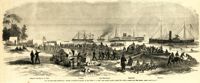
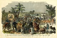
[Color image.] Caption: 'Feeding 8,000 people with rations of rice and salt at West Point Mills, on the Ashley River, Charleston S.C.-- From a sketch by our Special Artist, W.T. Crane.' [full date April 15, 1865.]
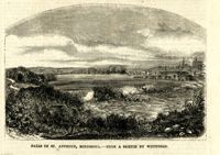
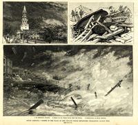
Main caption: 'South Carolina.--scenes in the track of the cyclone which devastated Charleston, August 25th. See page 43. 1. St. Michael's Church [upper left]. 2. Scene on the water front after the storm [top right]. 3. Destruction on South Battery [bottom].' [full date September 5, 1885.]
Caption: 'Scene on the arrival of Lieutenant Hall, U.S.A., with despatches (sic) from Major Anderson for Governor Pickens, at the Executive Mansion, Charleston, S.C., immediately after the firing on the Star of the West.--from a sketch by our Special Artist.--see page 151.' [full date January 26, 1861.]
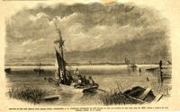
Caption: 'The advance upon Charleston--entrance to the Stono River, S.C.--from a sketch by Lieut. Coleman, 100th N.Y.S. Vol.' Also identified with captions: 'Kiawah Island and River. John's Island. Stono River. Cole's Island. Old Rebel Fort.' [full date April 25, 1863.]
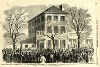
Caption: 'General McGowan addressing the Abbeville Volunteers in front of the Charleston Hotel--from a sketch by our Special Artist now in Charleston.' [full date February 23, 1861.]
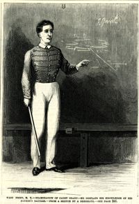
Caption: 'West Point, N.Y.--examination of Cadet Grant--he displays his knowledge of his father's battles.--from a sketch by A. Berghaus.--see page 241.' [full date June 24, 1871.]
[Color image.] Caption at top: 'The harbor of Charleston, S.C.--From sketches by our special artist.--Fort Moultrie, on Sullivan's Island.' Caption at middle: 'Fort Pinckney, Charleston, S.C.' Caption at bottom: 'Fort Sumter, Charleston, S.C.' [full date Dec. 1, 1860.]
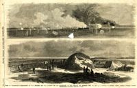
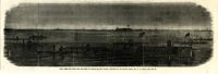
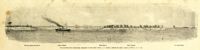
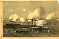
Caption: 'Panoramic view of Charleston Harbor--advance of iron-clads to the attack, April 7. Union--A. Keokuk. B. Nahunt. C. Nantucket. D. Catskill. E. Ironsides. F. Patapsco. G. Montauk. H. Passaie. K. Weehawken. Rebel--1. Morris Island sand battery. 2. Fort Wagner. 3. Battery Bee, on Cummings Point. 4. [Fort] Johnson. 5. Fort Ripley. 6. Sumter. 7. Charleston City. 8. Castle Pinckney. 9. Fort Redan. 10. Fort Moultrie. 11. Moultrie House. 12. Fort Beauregard. 13. Harbor obstructions. 14. Cooper River. 15. Ashley River.' [full date May 2, 1863.]
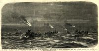
Caption: 'The night guard of boats on Charleston Bar during the first of the bombardment of Fort Sumpter (sic), to prevent reinforcements being sent to Major Anderson, April 12th, 1861.--from a sketch by our artist on Morris Island.'
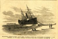
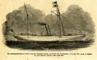
Caption: 'The Southern steamship Columbia. Captain Berry, on shore in Maffit's Bay, in the harbor of Charleston, S.C., on Wednesday, Jan. 23.--from a sketch by our Special Artist in Charleston.--see page 194.' [full date February 16, 1861.]
Caption: 'The bombardment of Fort Sumter, as seen through the "look out" in the pilot-house of one of the monitors, April 7.--from a sketch by our Special Artist.' [full date May 9, 1863]
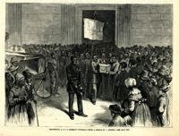
Caption: 'The Charleston Convention--interior of Douglas's headquarters, Hibernia (sic) Hall, Charleston, S.C.--from a sketch by our special artist.--see page 360.' [May 5, 1860.]
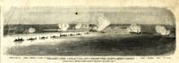
Caption: 'The advance upon Charleston--pioneer movement--landing of the 100th N.Y. Vols. upon Cole's Island, March 28.--from a sketch by our Special Artist.--see page 6.' Also identified with labels: Camp of 100th N.Y. Vols., Pawnee, Com. McDonough, Expounder and Belvidere. [full date April 25, 1863.]
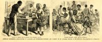
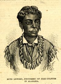
Main caption: 'American industries.--Silk culture in Alabama--an enterprise founded and carried on by Colored people at Huntsville.--from a sketch by A. Berghaus.' Caption left: 'Method of feeding the silkworms with mulberry leaves.' Caption right: 'Colored children carding the raw material.' [full date August 17, 1878.]
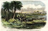
[Color image.] Caption: 'Negroes hunting the moccasin snake on the Ashley River, near Charleston, S.C.--from an original sketch by Granville Perkins, Esq.' [full date April 13, 1861.]
Main caption: 'Siege of Charleston--views of Sullivan's Island, as seen from Morris Island.--from sketches by our Special Artist, W.T. Crane.' Caption top left: 'Remains of blockade runners.' Caption top right: 'Rebel camp on Sullivans Island.' Caption middle left and right: 'Rebel battery on Sullivans Island.' Caption middle: 'Examining passes on the beach.' Caption bottom: ' Fort Moultrie as seen from Morris Island.' [full date October 10, 1863.]
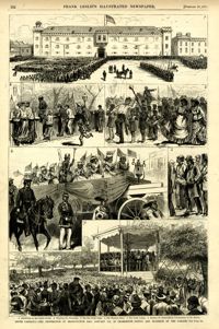
Caption: '1. Assembling on the Citadel Parade. 2. Watching the Procession. 3. The Boy Drum Corps. 4. The Thirteen States. 5. The Union League. 6. Reading the Emancipation Proclamation on the Battery. South Carolina--the celebration of Emancipation Day, January 8th. in Charleston--scenes and incidents of the parade--see page 375.' [full date February 10,1877]
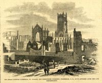
Caption: 'The Roman Catholic Cathedral, St. Finbar, and surrounding buildings, S.C., as it appeared after the late conflagration.' [full date November 1, 1862.]
Caption: 'Siege of Charleston--the magazine of Fort Moultrie exploded by a shell from the grounded monitor Weehawken, Sept. 8.--from a sketch by our own Special Artist, W.T. Crane.' [full date October 3, 1863.]
[Color image.] Caption: 'Unloading a transport with ambulances for the Army, at Wilmington, N.C.--View looking up Water Street.--sketched by our Special Artist.' [full date April 15, 1865.]
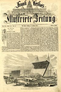
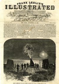
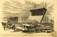
Caption: 'The Floating Battery, now erecting in the harbor of Charleston by the authorities of South Carolina. Designed to capture Fort Sumter.--from a sketch by our Special Artist now in Charleston. See page 194.' [full date February 16, 1861.]
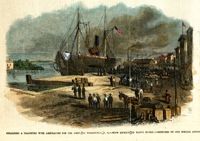
Caption: 'The Anglo-Confederate prize steamer Princess Royal captured off Charleston, January 29.--from a sketch by our Special Artist.--see page 366.' [full date February 28, 1863.]
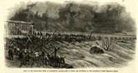
Caption: 'Flood on the Susquehanna River at Harrisburg--Accumulation of timber and driftwood at the Cumberland Valley Railroad Bridge.' [full date April 15, 1865]
Caption: 'The Siege of Charleston--the attempt to blow up the ironsides, Capt. Rowan, with a torpedo, Oct. 5.--from a sketch by our Special Artist.' [full date October 31, 1863.]
Caption: 'Moonlight scene on Sullivan's Island, Charleston Harbor--the sentry challenging Frank Leslie's Special Artist and Correspondent, who were guests of the Richland Rifles.--from a sketch by our Special Artist now in Charleston.' [full date March 2, 1861.]

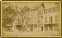
![[Elliott Street]](https://iiif.library.cofc.edu/iiif/2/50708/full/200,/0/default.jpg)