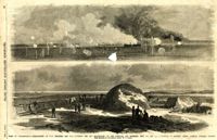
Caption: 'Siege of Charleston--1.Bombardment of Fort Moultrie and the Batteries Bee and Beauregard, by the monitors and ironsides, Sept. 7th and 8th.--2. Interior of Battery Gregg, looking towards Wagner. From sketches by our Special Artist, W.T. Crane.' [full date October 3, 1863.]
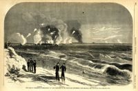
Caption: 'The Siege of Charleston--bombardment of Fort Moultrie by the iron-clads, September 8, 1863.--sketched by Mr. Theodore R. Davis.--[see page 621.] Also identified in the image: Moultrieville, Fort Moultrie and Moultrie House. [full date September 26, 1863.]
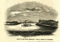
Caption: 'Night after the fight--the iron clads at anchor off Fort Sumter.--sketched by our Special Artist, Mr. W.T. Crane.--see page 81.' [full date May 2, 1863.]
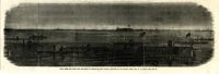
Caption: 'The siege of Charleston--View from the sea-face of Fort Wagner.--sketched by Mr. Theodore R. Davis.--[See Page 621.]' [full date September 26, 1863.]
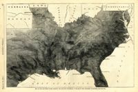
Caption: 'Map of the Southern states, showing the relative proportion of slaves in the different localities.--[see page 142.]' [full date February 28, 1863.]
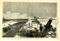
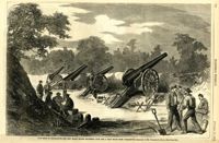
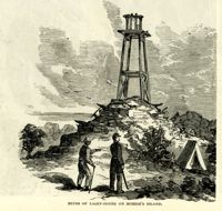
Caption: 'Folley's (sic) Battery, near the lighthouse, at Charleston, South Carolina.--from a sketch by A.P. Palmer, 21st South Carolina Volunteers.--[see page 79.]' [full date January 31, 1863.]
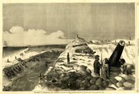
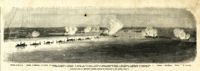
Caption: 'The Siege of Charleston--the morning call to the Rebels.--sketched from the naval battery by Mr. Theodore R. Davis.--[see page 603.]' [full date September 19, 1863.]
Caption: 'The siege of Charleston--View from the sea-face of Fort Wagner.--sketched by Mr. Theodore R. Davis.--[See Page 621.]' [full date September 26, 1863.]
Caption: 'Departure of the Great Southern Expedition from Beaufort, North Carolina.--sketched by an amateur.--[see page 119.]' [full date February 21, 1863.]
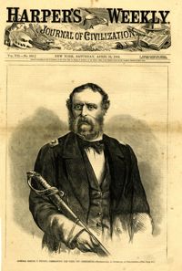
Caption: 'Admiral Samuel F. DuPont, Commanding the fleet off Charleston--photographed by Gutekurst, of Philadelphia.--see page 270.' [Full date April 25, 1863]
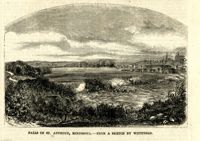
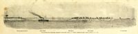
Caption: 'The advance upon Charleston--entrance to the Stono River, S.C.--from a sketch by Lieut. Coleman, 100th N.Y.S. Vol.' Also identified with captions: 'Kiawah Island and River. John's Island. Stono River. Cole's Island. Old Rebel Fort.' [full date April 25, 1863.]
Caption: 'The Siege of Charleston--the new Black Island Batteries, four and a half miles from Charleston.--sketches by Mr. Theodore R. Davis.--[see page 651.]' [full date October 10, 1863.]
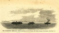
Caption: 'Panoramic view of Charleston Harbor--advance of iron-clads to the attack, April 7. Union--A. Keokuk. B. Nahunt. C. Nantucket. D. Catskill. E. Ironsides. F. Patapsco. G. Montauk. H. Passaie. K. Weehawken. Rebel--1. Morris Island sand battery. 2. Fort Wagner. 3. Battery Bee, on Cummings Point. 4. [Fort] Johnson. 5. Fort Ripley. 6. Sumter. 7. Charleston City. 8. Castle Pinckney. 9. Fort Redan. 10. Fort Moultrie. 11. Moultrie House. 12. Fort Beauregard. 13. Harbor obstructions. 14. Cooper River. 15. Ashley River.' [full date May 2, 1863.]
Caption: 'The Civil War in America: Confederates sinking torpedoes by moonlight in the harbour channel, Charleston.--from a sketch by our Special Artist.' [full date May 16, 1863.]
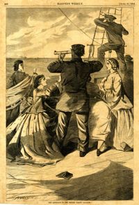
Caption: 'The bombardment of Fort Sumter, as seen through the "look out" in the pilot-house of one of the monitors, April 7.--from a sketch by our Special Artist.' [full date May 9, 1863]