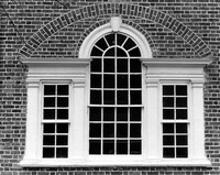
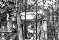
St. Stephen's Episcopal Church, 196 Brick Church Circle. Detail View of Rear window. St. Stephen, S.C.;8" x 10" B/W photo. Box 4, Folder 1-11-3. One copy.
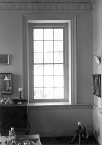
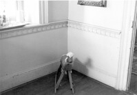
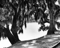
Seaside Plantation (Locksley Hall), off of Cypress Bottom Road. Interior View - 1st Floor, Dining Room. Detail of molding, window and chair rail. North elevation. Edisto Island, S.C.;5" x 7" B/W photo. Box 11, Folder 2-3-12. One copy.
Seaside Plantation (Locksley Hall), off of Cypress Bottom Road. Interior View - 1st Floor, Dining Room. Detail of chair rail and wainscot. North elevation. Edisto Island, S.C.;7" x 5" B/W photo. Box 11, Folder 2-3-12. One copy.
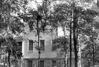
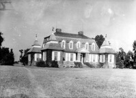
Marshlands Plantation, Fort Sumter Drive. Main House - View of North (Rear) elevation. James Island, S.C.;6.5" x 10" (and 3" x 5") B/W photo. Box 11, Folder 2-4-3. Two copies.
Marshlands Plantation, Fort Sumter Drive. Main House - View of East (Side) elevation. James Island, S.C.;6.5" x 10" (and 3" x 5") B/W photo. Box 11, Folder 2-4-3. Two copies.
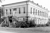
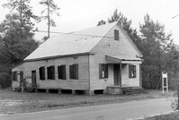
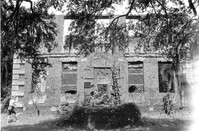
Old Lincolnville Town Hall (Williams Graded School), near intersection of East Randolph Street and East Pinckney Street. View of SE (Front and Side) elevation. Lincolnville, S.C.;6.5" x 10" B/W photo. Box 17, Folder 2-15-2. Three copies.
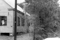
Old Lincolnville Town Hall (Williams Graded School), near intersection of East Randolph Street and East Pinckney Street. View of SW (Front and Side) elevation. Lincolnville, S.C.;6.5" x 10" B/W photo. Box 17, Folder 2-15-2. Two copies.
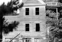
Old Lincolnville Town Hall (Williams Graded School), near intersection of East Randolph Street and East Pinckney Street. View of North (Rear) elevation. Lincolnville, S.C.;6.5" x 10" B/W photo. Box 17, Folder 2-15-2. Three copies.
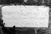
Old Lincolnville Town Hall (Williams Graded School), near intersection of East Randolph Street and East Pinckney Street. Detail View of cornerstone. Lincolnville, S.C.;6.5" x 10" B/W photo. Box 17, Folder 2-15-2. Three copies.
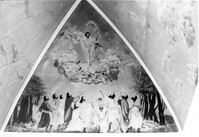
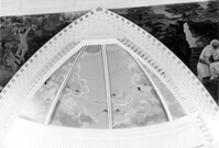
Central Baptist Church, 26 Radcliffe Street. Interior View - Detail of Balcony in Gable. South elevation. Charleston, S.C.;6.5" x 10" B/W photo. Box 9, Folder 2-1-156. One copy.
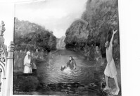
Central Baptist Church, 26 Radcliffe Street. Interior View - Detail of Mural in Apse. South elevation. Charleston, S.C.;6.5" x 10" B/W photo. Box 9, Folder 2-1-156. One copy.
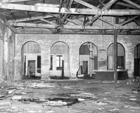
S.C. Railroad Car Shop (AAA Downtown Storage), 44 Line Street. Interior View. Charleston, S.C.;8" x 10" B/W photo. Box 18, Folder: Charleston: 44 Line Street, South Carolina Car Shop. One copy.
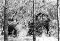
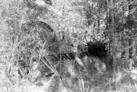
Fairlawn Plantation (Hugh Rose Plantation), Off of Guerins Bridge Road, adjacent to the Francis Marion National Forest. Detail View of Steam Engine for Rice Mill.;6.5" x 10" B/W photo. Box 19, Folder: Charleston County: Christ Church: Fairlawn Plantation. One copy.
Fairlawn Plantation (Hugh Rose Plantation), Off of Guerins Bridge Road, adjacent to the Francis Marion National Forest. Detail View of Steam Engine for Rice Mill.;6.5" x 10" B/W photo. Box 19, Folder: Charleston County: Christ Church: Fairlawn Plantation. One copy.
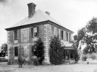
Brick House (Paul Hamilton House), Brick House Road (off of S.C. Hwy. 174). View of South (Front) elevation. Edisto Island, S.C.;6.5" x 10" B/W photo. Box 11, Folder 2-3-22. Two copies.
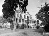
Marshlands Plantation, Fort Sumter Drive. Main House - View of SE (Front and Side) elevation. James Island, S.C.;8" x 10" B/W photo. Box 11, Folder 2-4-3. One copy.
Brick House (Paul Hamilton House), Brick House Road (off of S.C. Hwy. 174). View of SW (Side and Front) elevation. Edisto Island, S.C.;3" x 4" B/W photo. Box 11, Folder 2-3-22. One copy.
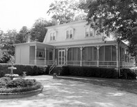
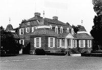
Magnolia Gardens, 3550 Ashley River Road. Main House and Grounds - View of South elevation. Charleston, S.C.;8" x 10" B/W photo. Box 13, Folder 2-9-6. Two copies.
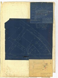
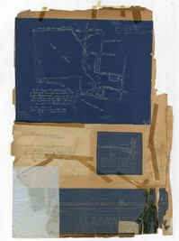
Page 259 of the City Engineer's Plat Book with three plats. Plat 1 shows lots located between Hester Street and Piedmont Street. Plat 1 also shows Alberta Street, Poplar Street, and a stretch of marsh land. Plat 2 shows lots located between Tradd Street, Ashley Street, and Murray Boulevard. Plat 2 also shows South Bay Street. Plat 3 shows a city block between Hester Street and Piedmont Avenue, and between Poplar Street and Alberta Avenue.
Page 256 of the City Engineer's Plat Book with four plats. Plat 1 shows land located between Elliot Street and Boundary Street, near Mill Street, Bee Street, President Street, and Doughty Street. It also shows several streams, a mill pond, and a large stretch of marsh land. Plat 2 shows a lot on Brigade Street. The third plat shows a lot and building located on the corner of Grove Street and Russell Street. The fourth plat shows lots located near the intersection of Grove Street and Tracy Street.
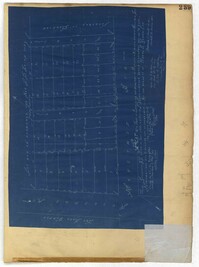
Page 248 of the City Engineer's Plat Book with two plats. Plat 1 shows lots and structures located between Wescott Court and President Street, north of Bee Street. Plat 2 shows lots on and near Huger Street, King Street, Congress Street, and Benson Street.
Page 252 of the City Engineer's Plat Book with two plats. Plat 1 shows lots on and near Lenwood Street, between South Bay Street and Boulevard Drive. Plat 2 shows lots located on and near the intersection of Huger Street and Rutledge Avenue.
Page 251 of the City Engineer's Plat Book with two plats. Plat 1 shows Meeting Street, Williman Street, and Romney Street. Plat 2 shows lots located on and near America Street, Lee Street, Cooper Street, and Drake Street.
Page 257 of the City Engineer's Plat Book with two plats. Plat 1 shows lots located between St. Margaret Street and Grove Street. Plat 2 shows lots located along Marsh Street and Concord Street, near where they intersect with Laurens Street.
Page 255 of the City Engineer's Plat Book with two plats. Plat 1 features lots located between St. Margaret Street and Grove Street, and between Tenth Street and Eleventh Street. Plat 2 features lots and structures located on the intersection of Aiken Street and Hampden Court.
Page 250 of the City Engineer's Plat Book with one plat. The plat shows lots between Romney Street and Williman Street, and east of Meeting Street. The plat also shows Isabella Street.
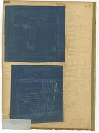
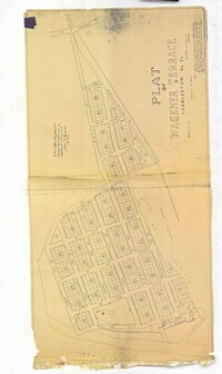
Page 254 of the City Engineer's Plat Book with one plat. A "Plat of Wagner Terrace," showing numerous lots and Hampton Park. Streets shown include Dunneman Street, Grove Street, and Rutledge Avenue.
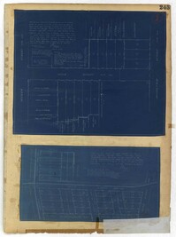
Page 243 of the City Engineer's Plat Book with three plats. Plat 1 features lots along Cumberland Street, near where it intersects with State Street. The second plat features "City Lands West of President Street and South of Congress Street." It also labels reading "Old Folks Holme," "Grave Yard Old Folks Home," "City Board of Public School Commissioners," and "Colored Industrial School." Plat 3 shows lots located west of Meeting Street, and also shows Cooper Street, Lee Street, Sheppard Street, and Sumter Street.
Page 244 of the City Engineer's Plat Book with three plats. Plat 1 shows lots and structures located along Maple Street, near where it intersects with Meeting Street. Plat 2 features a lot located on the east side of Tenth Street, between St. Margaret Street and Grove Street. Plat 3 shows land located near the intersection of State Street and Cumberland Street.
Page 246 of the City Engineer's Plat Book with one plat. The plat shows lots located between Rutledge Avenue and the Ashley River. Groups of lots are labelled with red letters. The plat also shows Darlington Avenue, Ashley Avenue, Piedmont Avenue, Hester Street, Clemson Street, Maple Street, Peachtree Street, Poplar Street, Pendleton Street, and Sans Souci Street.
Page 247 of the City Engineer's Plat Book with one plat. The plat shows lots located from the west side of Ashley Avenue to King Street, between Mount Pleasant and Sans Souci Street. The plat also shows Darlington Street, Rutledge Avenue, Magnolia Street, Tracy Street, and Laurel Avenue.
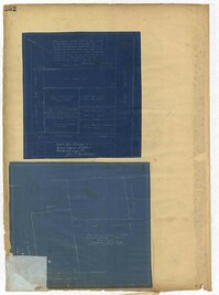
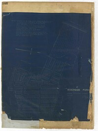
Page 240 of the City Engineer's Plat Book with one plat. The plat shows "The Property of Riverside Park Inc. and Peerless Securities Co." The streets shown include Rutledge Avenue, Sans Souci Street, Hester Street, and Ashley Avenue.
Page 245 of the City Engineer's Plat Book with two plats. Plat 1 shows lots located on and near Seyle Street, between Huger Street and Moultrie Street. Plat 2 shows lots on and near Grove Street, between Rutledge Avenue and King Street. Plat 2 also shows Tracy Street.
Page 242 of the City Engineer's Plat Book with one plat. The plat shows lots located on and near King Street, between Cypress Street and Romney Street. It also features a stretch of railroad track.
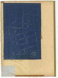
Page 241 of the City Engineer's Plat Book with one plat. The plat shows lots on and near King Street, Baxter Street, and Lenox Street. It also shows the end of Sans Souci Street.
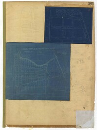
Page 235 of the City Engineer's Plat Book with four plats. Plat 1 features a proposed right-of-way through Chicora Park, and shows a state road, Clements Avenue, Pine Avenue, and a label reading "U. S. Navy Yard." Plat 2 shows land located near the intersection of Grove Street and Rutledge Avenue, with one plot labeled "Trustees of the Endowment Fund of the Charleston Library Society." Plat 3 shows lots, structures, and marshland located on and near the Ashley River, north of Congress Street. the fourth plat is a pencil-sketched map showing land located near the intersection of Rutledge Avenue and Grove Street.
Page 237 of the City Engineer's Plat Book with three plats. Plat 1 shows "property situated on the west side of Rutledge Avenue," most of which is situated between Grove Street and Moultrie Street. Plat 1 also marks a "Brick Dwelling" and a stretch of marsh land. Plat 2 features land labeled "Trustees of the Endowment Fund of the Charleston Library Society," located between Rutledge Avenue and the Ashley River. Plat 3 shows land located on Huger Street, between King Street and Meeting Street.
Page 229 of the City Engineer's Plat Book with two plats. Plat 1 features lots located on Queen Street, near its intersections with Mazyck Street, Friend Street, King Street, and Meeting Street. Plat 2 features lots located between Sans Souci Street and Simons Street, and between Rutledge Avenue and King Street.