Search
« Previous |
1 - 100 of 1,815
|
Next »
Search Results
Date:
1977-1983
Description:
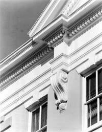
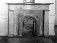
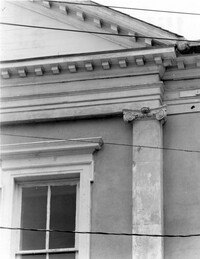
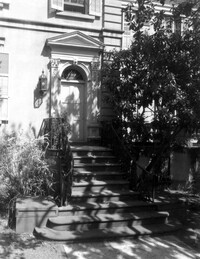
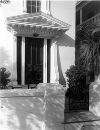
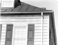
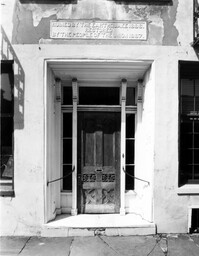
82 - 86 Broad Street, ca 1753. Detail View of console, West (Side) elevation. 4" x 5" B/W photo.
Date:
1977-1983
Description:
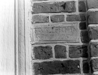
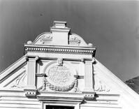
Berkeley County, St. Stephen's Church, ca. 1767. Detail View of plaque bearing architect/builder's name (F. Villepontoux), South (Side) elevation (located to right of door jamb). 4" x 5" B/W photo.
Date:
1977-1983
Description:
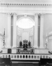
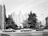
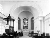
275 Meeting Street, Trinity Methodist Church, ca. 1848. Interior View - Detail of chancel and altar, East elevation. 4" x 5" B/W photo.
Date:
1977-1983
Description:
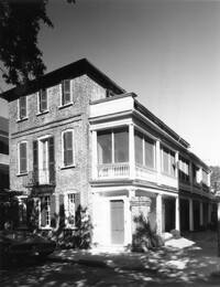
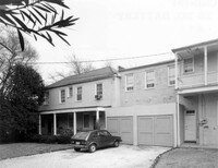
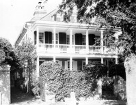
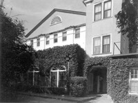
94 Church Street, Cooper-Bee House, ca. 1760. View of SW (Front and Side) elevation. 4" x 5" B/W photo.
Date:
1977-1983
Description:
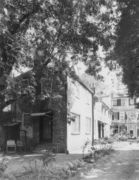
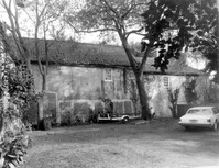
31 Legare Street, Hannah Heyward House, ca. 1789. View of Stable, Carriage House, and Kitchen House. 4" x 5" B/W photo.
Date:
1977-1983
Description:
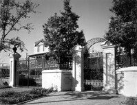
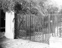
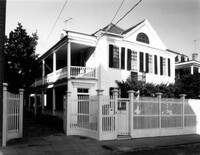
14 Green Street, Knox-Lesesne House, ca. 1846. View of entry gates. 4" x 5" B/W photo.
Date:
1977-1983
Description:
405 King Street, St. Matthews Lutheran Church, ca. 1867. Sunday School Building - Detail View of entry, East (Front) elevation. 4" x 5" B/W photo.
Date:
1977-1983
Description:
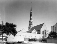
405 King Street, St. Matthews Lutheran Church, ca. 1867. Sunday School Building and Office Building - View of East (Front) elevation. 4" x 5" B/W photo.
Date:
1977-1983
Description:
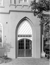
405 King Street, St. Matthews Lutheran Church, ca. 1867. Church - Detail View of center entry, East (Front) elevation. 4" x 5" B/W photo.
Date:
1977-1983
Description:
405 King Street, St. Matthews Lutheran Church, ca. 1867. Whole Proprty - View of NW (Rear and Side) elevation. 4" x 5" B/W photo.
Date:
1977-1983
Description:
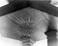
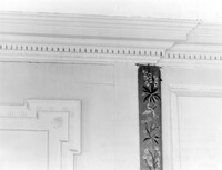
Berkeley County, St. Stephen's Church, ca. 1767. Detail View of soffitt in pulpit roof. 4" x 5" B/W photo.
Date:
1977-1983
Description:
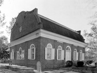
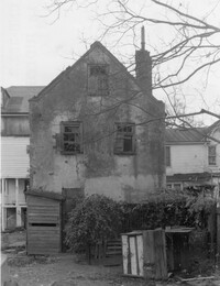
Berkeley County, St. Stephen's Church, ca. 1767. View of NE (Rear and Side) elevation. 4" x 5" B/W photo.
Date:
1977-1983
Description:
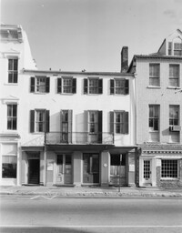
82 - 86 Broad Street, ca 1753. View of East (Front) elevation. 4" x 5" B/W photo.
Date:
1977-1983
Description:
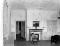
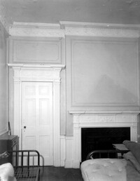
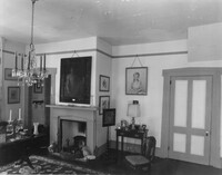
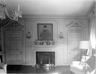
48 Elizabeth Street, Aiken-Rhett House, ca.1818. Main House - Interior View. 2nd Floor - SW Room, East and South walls. 4" x 5" B/W photo.
Date:
1977-1983
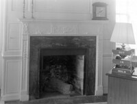
Description:
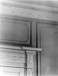
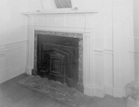
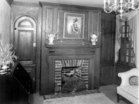
48 Elizabeth Street, Aiken-Rhett House, ca.1818. Main House - Interior View. 2nd Floor - SE Room. Detail of mantle. 4" x 5" B/W photo.
Date:
1977-1983
Description:
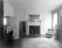
48 Elizabeth Street, Aiken-Rhett House, ca.1818. Main House - Interior View. 2nd Floor - SW Room, North wall. 4" x 5" B/W photo.
Date:
1977-1983
Description:
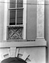
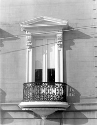
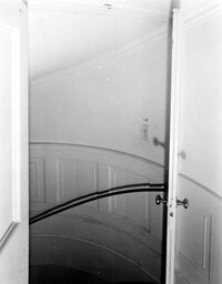
51 Meeting Street, Nathaniel Russell House, ca. 1808. Main House - Detail View of oval stair hall window, North (Side) elevation. 4" x 5" B/W photo.
Date:
1977-1983
Description:
Charleston County, Oak Island Plantation, ca. 1830. Interior View. 1st Floor - NE Room, South wall. 4" x 5" B/W photo.
Date:
1977-1983
Description:
6 Gibbes Street, Parker-Drayton House, ca.1806. View of SW (Front and Side) elevation. 4" x 5" B/W photo.
Date:
1977-1983
Description:
286 Calhoun Street, Jonathan Lucas House, ca. 1809. Main House - Interior View. 1st Floor - SE Room, Detail of door and mantle, North elevation. 4" x 5" B/W photo.
Date:
1977-1983
Description:
286 Calhoun Street, Jonathan Lucas House, ca. 1809. Main House - Interior View. 1st Floor - SE Room, Detail of cornice and door entablature. 4" x 5" B/W photo.
Date:
1977-1983
Description:
286 Calhoun Street, Jonathan Lucas House, ca. 1809. Main House - Interior View. 1st Floor - NE Room, Detail of mantle, South wall. 4" x 5" B/W photo.
Date:
1977-1983
Description:
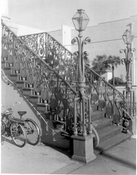
188 Meeting Street, Market Hall, ca. 1841. Main Hall - Detail View of 1st Floor stoop, West (Front) elevation. 4" x 5" B/W photo.
Date:
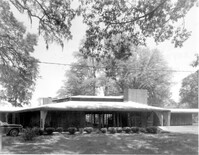
1977-1983
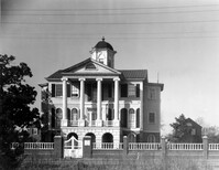
Description:
Beaufort County, Auldbrass Plantation, ca. 1951. Main House - View of Central Block, West elevation. 4" x 5" B/W photo.
Date:
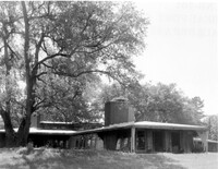
1977-1983
Description:
Beaufort County, Auldbrass Plantation, ca. 1951. Main House - View of Bedroom Wing, SE elevation. 4" x 5" B/W photo.
Date:
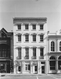
1977-1983
Description:
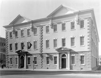
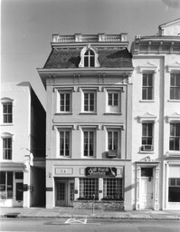
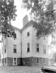
15 Broad Street, Smith Building, ca. 1800-1815. View of North (Front) elevation. 4" x 5" B/W photo.
Date:
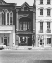
1977-1983
Description:
13 Broad Street, ca.1890. View of North (Front) elevation. 4" x 5" B/W photo.
Date:
1929-03-11
Description:
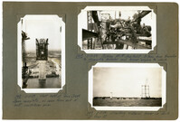
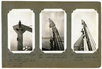
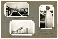
Image #147 (4.5" x 2.75"): "3-11-29. West half of Town Creek Span complete, as seen from end of east cantilever arm."; Image #148 (2.75" x 4.5"): "3-11-29. Picking 150 HP Gas. Hoist, 31 tons, from traveler to dismantle traveler and lower engine to deck."; Image #149 (2.75" x 4.5"): "3-11-29. Erecting material tower on dock at Pier 13.";Three 4.5" x 2.75" B/W photos numbered 147, 148, 149
Date:
1929-06-21
Description:
Image #474 (4.5" x 2.75"): "6-21-29. Erecting the last bottom chord section L19' L21', north truss, east half of suspended span."; Image #475 (2.75" x 4.5"): "6-21-29. Connecting the closing bottom chord at L21'."; Image #476 (2.75" x 4.5"): "6-21-29. Closing B.C. joint L21'. Note 6" [diameter] pin and slotted hole with 7" movement for adjustment, temperature, etc.";Three 4.5" x 2.75" B/W photos numbered 474, 475, 476
Date:
1929-06-21
Description:
Image #471 (2.75" x 4.5"): "Progress. Ready to place the last 87 1/6" bottom chord section."; Image #472 (2.75" x 4.5"): "6-21-29. Ready for the last or closing bottom chord sections."; Image #473 (4.5" x 2.75"): "6-21-29. From below. West cantilever, below. East cantilever, above.";Three 4.5" x 2.75" B/W photos numbered 471, 472, 473
Date:
1929-06-21
Description:
Unnumbered Image (5" x 7"): "Progress - Cooper River Span, June 21, 1929 at 4:30 P.M. First closing bottom chord in place.";One 5" x 7" B/W photo
Date:
1977-1983
Description:
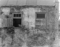
72 - 74 Tradd Street, Fotheringham-McNeil Tenements, ca. 1765. Detail View of jerkin head on gambrel roof, NW (Rear and Side) elevation. 4" x 5" B/W photo.
Date:
1977-1983
Description:
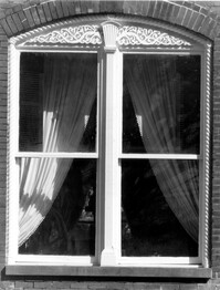
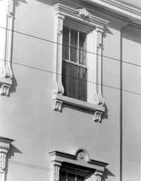
16 Meeting Street, Calhoun Mansion, ca. 1876. Detail View of 1st Floor window, West (Front) elevation. 4" x 5" B/W photo.
Date:
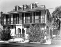
1977-1983
Description:
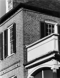
64 South Battery, William Gibbes House, ca. 1772. Main House - View of East (Side) elevation. 4" x 5" B/W photo.
Date:
1977-1983
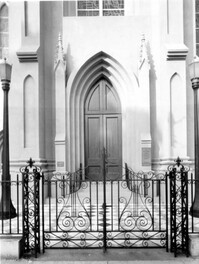
Description:
10 Archdale Street, Saint John's Lutheran Church, ca. 1816. Interior View - altar and pulpit. West (Front) elevation 4" x 5" B/W photo.
Date:
1977-1983
Description:
68 South Battery, Harth-Middleton House, ca. 1797. Main House - View of West (Side) elevation. 4" x 5" B/W photo.
Date:
1977-1983
Description:
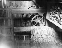
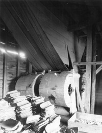
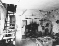
Georgetown County, Mansfield Plantation, ca. 1780. Rice Threshing Mill - Interior View. Pulleys for belt connection from boiler to thresher. 4" x 5" B/W photo.
Date:
1977-1983
Description:
Georgetown County, Wicklow Hall Plantation, ca. 1825. Main House - Interior View. 1st Floor - SW Room, North elevation. 4" x 5" B/W photo.
Date:
1977-1983
Description:
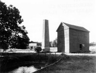
Georgetown County, Mansfield Plantation, ca. 1780. Rice Threshing Mill and Chimney Stack - View of Front and Side elevation. 4" x 5" B/W photo.
Date:
1977-1983
Description:
Georgetown County, Mansfield Plantation, ca. 1780. Rice Threshing Mill - Interior View. Threshers, SW elevation. 4" x 5" B/W photo.
Date:
1977-1983
Description:
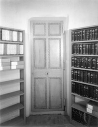
100 Meeting Street, Fireproof Building, ca. 1822. Interior View - Ground Floor. Stair Hall - Original vault door, South elevation. 4" x 5" B/W photo.
Date:
1977-1983
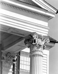
Description:
122 East Bay Street, Exchange Building & Customs House, ca. 1767. Detail View of cornice and pilaster, (West) Front elevation. 4" x 5" B/W photo.
Date:
1977-1983
Description:
90 Church Street, Thomas Legare House, ca. 1759. Main House - Detail View of cornice and portico, SW (Front and Side) elevation. 4" x 5" B/W photo.
Date:
1977-1983
Description:
122 East Bay Street, Exchange Building & Customs House, ca. 1767. Detail View of wrought iron grille and pilaster base. 4" x 5" B/W photo.
Date:
1977-1983
Description:
100 Meeting Street, Fireproof Building, ca. 1822. Interior View - 1st Floor. NW Room - West wall, North elevation. 4" x 5" B/W photo.
Date:
1977-1983
Description:
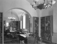
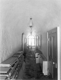
100 Meeting Street, Fireproof Building, ca. 1822. Interior View - Ground Floor. West corridor, North elevation. 4" x 5" B/W photo.
Date:
1977-1983
Description:
87 Church Street, Heyward-Washington House, ca. 1770. Kitchen House - Interior View. East Room, West elevation. 4" x 5" B/W photo.
Date:
1977-1983
Description:
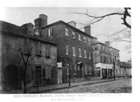
87 Church Street, Heyward-Washington House, ca. 1770. Copy of 1833 photo. Main House - View of East (Front) elevation. 4" x 5" B/W photo.
Date:
1977-1983
Description:
48 Elizabeth Street, Aiken-Rhett House, ca.1818. Main House - Detail View of portico and door to 2nd Floor Hall, South (Front) elevation. 4" x 5" B/W photo.
Date:
1977-1983
Description:
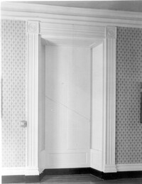
48 Elizabeth Street, Aiken-Rhett House, ca.1818. Main House - Detail View of 1st Floor triple window exterior shutter and architrave. 4" x 5" B/W photo.
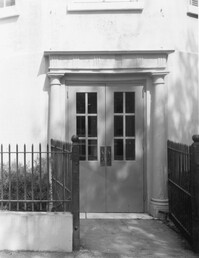
Date:
1977-1983
Description:
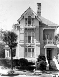
94 Rutledge Avenue, Isaac Jenkins Mikell House, ca. 1851. Main House - Detail View of entry, West (Front) elevation 4" x 5" B/W photo.
Date:
1977-1983
Description:
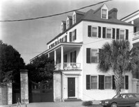
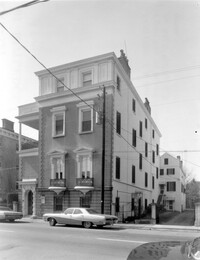
25 East Battery, Charles Drayton House, ca. 1883 - 1886. View of SE (Side and Front) elevation. 4" x 5" B/W photo.
Date:
1977-1983
Description:
43 East Battery, George Sommers House, ca. 1755. View of NE (Front and Side) elevation. 4" x 5" B/W photo.
Date:
1977-1983
Description:
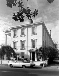
29 Broad Street, McCauley-Davis House, ca. 1790, 1886. View of North (Front) elevation. 4" x 5" B/W photo.
Date:
1977-1983
Description:
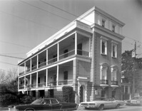
25 East Battery, Charles Drayton House, ca. 1883 - 1886. View of East (Front) elevation. 4" x 5" B/W photo.
Date:
1977-1983
Description:
93 Rutledge Avenue, Seabrook-Trenholm House, ca. 1819. Detail View of entry, East (Front) elevation. 4" x 5" B/W photo.
Date:
1977-1983
Description:
93 Rutledge Avenue, Seabrook-Trenholm House, ca. 1819. View of NE (Front and Side) elevation. 4" x 5" B/W photo.
Date:
1977-1983
Description:
81 Rutledge Avenue, Glover-Sottile House, ca. 1826. View of SE (Front and Side) elevation. 4" x 5" B/W photo.
Date:
1977-1983
Description:
81 Rutledge Avenue, Glover-Sottile House, ca. 1826. View of NE (Front and Side) elevation. 4" x 5" B/W photo.
Date:
1977-1983
Description:
185 Rutledge Avenue, Thomas Doughty House, ca. 1798. Detail View of cornice. 4" x 5" B/W photo.
Date:
1977-1983
Description:
33 Broad Street, John Smith House, ca. 1785. View of North (Front) elevation. 4" x 5" B/W photo.
Date:
1977-1983
Description:
93 Rutledge Avenue, Seabrook-Trenholm House, ca. 1819. Detail View of 2nd Floor windows, East (Front) elevation. 4" x 5" B/W photo.
Date:
1977-1983
Description:
81 Rutledge Avenue, Glover-Sottile House, ca. 1826. Detail View of 1st Floor window, East (Front) elevation. 4" x 5" B/W photo.
Date:
1977-1983
Description:
64 South Battery, William Gibbes House, ca. 1772. Main House - Detail View of 1st Floor entry, South (Front) elevation. 4" x 5" B/W photo.
Date:
1977-1983
Description:
10 Judith Street, John Robinson House, ca. 1814. Kitchen House - Detail View of windows, East (Side) elevation. 4" x 5" B/W photo.
Date:
1977-1983
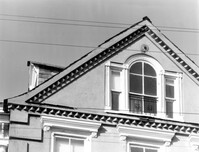
Description:
95 Rutledge Avenue, Grimke-Seabrook House, ca. 1819. Detail View of Pediment, East (Front) elevation. 4" x 5" B/W photo.
Date:
1977-1983
Description:
10 Judith Street, John Robinson House, ca. 1814. Kitchen House - View of SE (Rear and Side) elevation. 4" x 5" B/W photo.
Date:
1977-1983
Description:
14 George Street, Middleton-Pinckney House, ca. 1796. Detail View of entry, South (Front) elevation. 4" x 5" B/W photo.
Date:
1977-1983
Description:
2 - 4 Court House Square, Daniel Blake Tenements, ca. 1760. Interior View - 1st Floor. SW Room - Detail of mantle, West elevation. 4" x 5" B/W photo.
Date:
1977-1983
Description:
60 - 64 Broad Street, The Confederate Home, ca. 1800. Detail View of main entry, South (Front) elevation. 4" x 5" B/W photo.
Date:
1977-1983
Description:
10 Judith Street, John Robinson House, ca. 1814. Kitchen House - View of North (Side) elevation. 4" x 5" B/W photo.
Date:
1977-1983
Description:
68 Broad Street, Daniel Ravenel House, ca. 1796. Dependency, View of NW (Side and Front) elevation. 4" x 5" B/W photo.
Date:
1977-1983
Description:
64 South Battery, William Gibbes House, ca. 1772. Main House - Interior. 1st Floor - SW Room, Detail of cornice. 4" x 5" B/W photo.
Date:
1977-1983
Description:
64 South Battery, William Gibbes House, ca. 1772. Main House - Interior. 1st Floor - SE Room, North elevation. 4" x 5" B/W photo.
Date:
1977-1983
Description:
64 South Battery, William Gibbes House, ca. 1772. Main House - Interior. 1st Floor - NW Room, South elevation. 4" x 5" B/W photo.
Date:
1977-1983
Description:
105 Meeting Street, Hibernian Society Hall, ca. 1840. Interior View. Ground Floor - Meeting Room, Detail of window (with shutters closed). 4" x 5" B/W photo.
Date:
1977-1983
Description:
172 Tradd Street, Chisolm-Alston House, ca. 1836. Detail View of portico column, capitals and cornice, South (Front) elevation. 4" x 5" B/W photo.
Date:
1977-1983
Description:
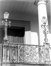
26 South Battery, Colonel John Algernon Sydney Ashe House, ca. 1853. Dependencies - East (Front) elevation. 4" x 5" B/W photo.
Date:
1977-1983
Description:
64 South Battery, William Gibbes House, ca. 1772. Dependency - View of West (Rear) elevation, South end. 4" x 5" B/W photo.
Date:
1977-1983
Description:
32 South Battery, Colonel John Ashe House, ca. 1762. Main House - Detail View of carriage gates. 4" x 5" B/W photo.
Date:
1977-1983
Description:
18 Bull Street, William Blacklock House, ca. 1800. Main House - Interior View. 1st Floor - Stair Hall, stairwell. 4" x 5" B/W photo.
Date:
1977-1983
Description:
35 Church Street, Young-Johnson House, ca. 1770. View of SE (Front and Side) elevation. 4" x 5" B/W photo.
Date:
1977-1983
Description:
37 Church Street, George Matthews House, ca. 1743. View of SE (Front and Side) elevation. 4" x 5" B/W photo.
Date:
1977-1983
Description:
39 Church Street, George Everleigh House, ca. 1743. View of South (Front) elevation. 4" x 5" B/W photo.
Date:
1977-1983
Description:
Charleston County (2695 Laurel Hill Road), Prospect Hill Plantation, ca. 1861. View of NW (Side and Rear) elevation. 4" x 5" B/W photo.
Date:
1977-1983
Description:
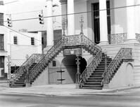
188 Meeting Street, Market Hall, ca. 1841. Main Hall - Detail View of stairs, SW (Front and Side) elevation. 4" x 5" B/W photo.
Date:
1977-1983
Description:
188 Meeting Street, Market Hall, ca. 1841. Main Hall - Detail View of stairs, West (Front) elevation. 4" x 5" B/W photo.
Date:
1977-1983
Description:
54 Queen Street, Thomas Elfe House, ca. 1760. Interior View - 1st Floor. South Room, East wall. 4" x 5" B/W photo.
Date:
1977-1983
Description:
635 East Bay Street, Faber-Ward House, ca. 1832. Main House and Complex - View of East (Front) elevation 4" x 5" B/W photo.
Date:
1977-1983
Description:
56 South Battery, Osborn-McCrady House, ca. 1770. View of South (Front) elevation. 4" x 5" B/W photo.
Date:
1977-1983
Description:
54 South Battery, date unknown. Detail View of gable, South elevation. 4" x 5" B/W photo.
Date:
1977-1983
Description:
172 Rutledge Avenue, Ashley Hall, ca. 1802. Kitchen House - Detail View of pediment and 2nd Floor, South (Front) elevation. 4" x 5" B/W photo.
Date:
1977-1983
Description:
172 Rutledge Avenue, Ashley Hall, ca. 1802. Main House - Detail View of 1st Floor and pediment, South (Front) elevation. 4" x 5" B/W photo.
Date:
1977-1983
Description:
172 Rutledge Avenue, Ashley Hall, ca. 1802. Main House - Detail View of bay 1st Floor railing, West (Side) elevation. 4" x 5" B/W photo.
Date:
1977-1983
Description:
64 South Battery, William Gibbes House, ca. 1772. Main House - Interior. 1st Floor - NE Room, Detail of mantle. 4" x 5" B/W photo.
Date:
1977-1983
Description:
68 South Battery, Harth-Middleton House, ca. 1797. Main House - Detail View of garden railing and pass gate. 4" x 5" B/W photo.
Date:
1977-1983
Description:
64 South Battery, William Gibbes House, ca. 1772. Dependency - View of South (Side) elevation. 4" x 5" B/W photo.
Date:
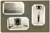
1929-05-29
Description:
Image #374 (4.5" x 2.75"): "5-29-29. Top chord joint at U10 - Span 7. Navy destroyers below. Elev. of peak approx. 280 ft. above low water. (S.R. Graham)."; Image #375 (4.5" x 2.75"): "5-29-29. Detail of main boom, hooked onto chord U8 U10."; Image #376 (4.5" x 2.75"): "5-29-29. Erecting U 8 U10. Span 9. (See 373).";Three 4.5" x 2.75" B/W photos numbered 374, 375, 376
Date:
1929-05-17
Description:
Image #320 (2.75" x 4.5"): "5-17-29. Setting timber forms for concrete deck, East Approach."; Image #321 (4.5" x 2.75"); "5-17-29. Bowed plates in expansion joint at 9E on the East Approach. Taken to illustrate shop error. report made to V.B. & Iron Co."; Image #322 (2.75" x 4.5"): "5-17-29. Progress in Cooper River.";Three 4.5" X 2.75" B/W photos numbered 320, 321, 322
Date:
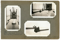
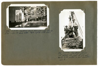
1929-05-29
Description:
Image #372 (2.75" x 4.5"): "5-29-29. Looking down from U10, over Pier 8. Elev. = 280 ft. above water. Note lighter with steel."; Image #373 (4.5" x 2.75"): "5-29-29. Top chord U8 U10 just entered into joint at U8 and ready to be pulled in and connected. Span 9.";Two 4.5" x 2.75" B/W photos numbered 372, 373