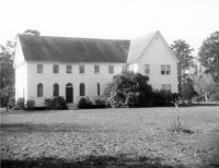
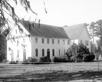
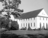
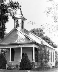
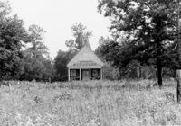
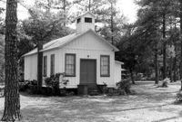
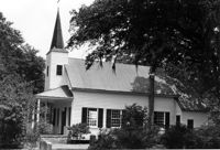
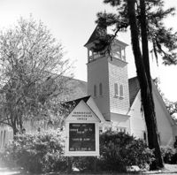
Johns Island Presbyterian Church, 2550 Bohicket Road. Church - View of Front elevation. Johns Island, S.C.;8" x 10" B/W photo. Box 12, Folder 2-5-4. Two copies.
Johns Island Presbyterian Church, 2550 Bohicket Road. Church - View of Front elevation. Johns Island, S.C.;8" x 10" B/W photo. Box 12, Folder 2-5-4. One copy.
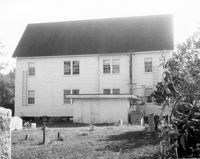
Johns Island Presbyterian Church, 2550 Bohicket Road. Church - View of Rear elevation. Johns Island, S.C.;8" x 10" B/W photo. Box 12, Folder 2-5-4. One copy.
Johns Island Presbyterian Church, 2550 Bohicket Road. Church - View of Front elevation. Johns Island, S.C.;8" x 10" B/W photo. Box 12, Folder 2-5-4. One copy.
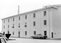
U.S. Coast Guard Historical District, I'on Avenue. Bunker - View of NW (Side and Front) elevation. Sullivans Island, S.C.;6.5" x 10" (and 3.5" x 5") B/W photo. Box 16, Folder 2-13-1. Two copies.
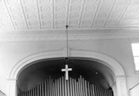
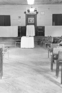
Old Bethel Methodist Church, 222 Calhoun Street. Interior View - Detail of Chancel. NE (Front and Side) elevation. Charleston, S.C.;6.5" x 10" B/W photo. Box 7, Folder 2-1-43. One copy.
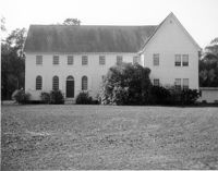
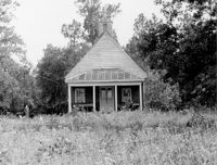
Johns Island Presbyterian Church, 2550 Bohicket Road. Church - View of Front and Side elevation. Johns Island, S.C.;8" x 10" B/W photo. Box 12, Folder 2-5-4. One copy.
Johns Island Presbyterian Church, 2550 Bohicket Road. Church - View of Front and Side elevation. Johns Island, S.C.;8" x 10" B/W photo. Box 12, Folder 2-5-4. One copy.
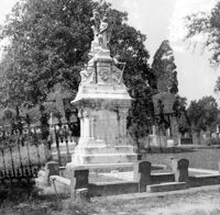
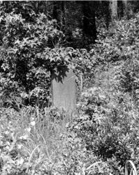
Magnolia Cemetery, Huguenin Avenue and Algonquin Road. Tombstone of Birt family. View of Front elevation. NOTE: Print has superimposed second image. Charleston, S.C.;8" x 8" B/W photo. Box 5, Folder 2-1-3. Two copies.
Rockville Historic District - Grace Episcopal Chapel (Grace Epsicopal Church), Grace Chapel Road. View of Front and Side elevation. Wadmalaw, S.C.;10" x 6.5" (and 10" x 8") B/W photo. Box 17, Folder 2-14-18. Two copies.
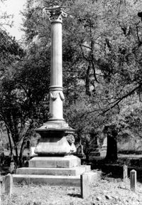
Magnolia Cemetery, Huguenin Avenue and Algonquin Road. Monument of Hugh Swinton Legare. View of Front and Side elevation. Charleston, S.C.;10" x 6.5" B/W photo. Box 5, Folder 2-1-3. One copy.
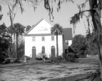
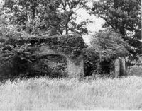
Tavou Church (Taveau Church), Strawberry Ferry Road (S.C. State Road 44). View of Side elevation. Moncks Corner, SC.;6.5" x 9.5" B/W photo. Box 2, Folder 1-3-12. One copy.
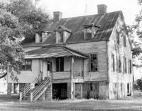
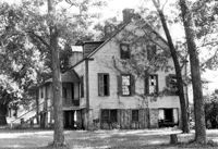
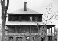
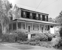
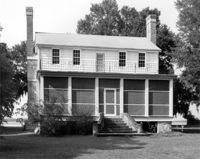
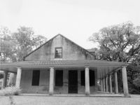
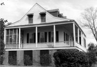
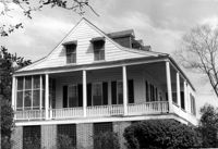
Rockville Historic District - Hagood House (Micah Jenkins House), Grace Chapel Road. View of South (Front) elevation. Wadmalaw Island, S.C.;6.5" x 10" B/W photo. Box 17, Folder 2-14-16. One copy.
Rockville Historic District - Hagood House (Micah Jenkins House), Grace Chapel Road. View of South (Front) elevation. Wadmalaw Island, S.C.;8" x 10" B/W photo. Box 17, Folder 2-14-16. One copy.
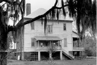
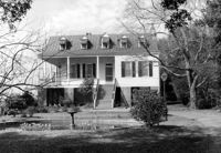
Rockville Historic District - Old Episcopal Rectory, Maybank Highway. View of SE (Side and Front) elevation. Wadmalaw Island, S.C.;6.5" x 10" B/W photo. Box 17, Folder 2-14-13. One copy.
Rockville Historic District - Mary A. Whaley House, Maybank Highway. View of West (Side) elevation. Wadmalaw Island, S.C.;6.5" x 10" B/W photo. Box 17, Folder 2-14-12. One copy.
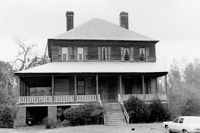
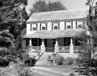
Rockville Historic District - Perry House, Maybank Highway. View of South (Front) elevation. Wadmalaw Island, S.C.;6.5" x 10" B/W photo. Box 17, Folder 2-14-14. One copy.
Rockville Historic District - W.E. Jenkins House (James LaRoche House). View of South (Front) elevation. Wadmalaw Island, S.C.;6.5" x 10" B/W photo. Box 17, Folder 2-14-15. One copy.
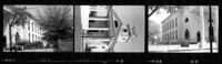
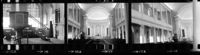
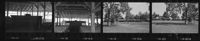
Cathedral of St. Luke and St. Paul, 126 Coming Street. Contact Sheet 7 - Views of Front and Sides elevations. Charleston, S.C.;1" x 4.5" B/W photo. Box 20, Folder: Miscellaneous Photos: Scanned Contact Sheets. One copy.
Cathedral of St. Luke and St. Paul, 126 Coming Street. Contact Sheet 7 - Views of Rear and Sides elevations. Charleston, S.C.;1" x 9" B/W photo. Box 20, Folder: Miscellaneous Photos: Scanned Contact Sheets. One copy.
Cathedral of St. Luke and St. Paul, 126 Coming Street. Contact Sheet 7 - Views of Interior. Charleston, S.C.;1" x 4.5" B/W photo. Box 20, Folder: Miscellaneous Photos: Scanned Contact Sheets. One copy.
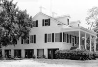
Stony Landing Plantation, East of U.S. Hwy. 52 and Riverwood Drive, along the Cooper River. View of Side and Front elevation. Moncks Corner, SC.;6.5" x 9.5" B/W photo. Box 2, Folder 1-8-5. One copy.
Church of the Redeemer (Pineville Chapel), Matilda Circle. Interior View - Detail of Front Entrance. NW (Front) elevation. Pineville Historic District. Pineville, SC.;6.5" x 9.5" B/W photo. Box 3, Folder 1-9-1 (I). One copy.
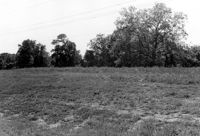
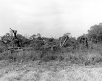
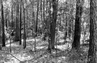
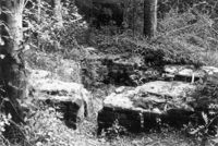
Stono River Rebellion Site (Cato's Rebellion Site), North Side of U.S. Highway 17, west of the Wallace River. View looking West. Hollywood, S.C.;6.5" x 10" B/W photo. Box 16, Folder 2-11-16. One copy.
Old Rectory (Gourdin House). View of North (Front and Side) elevation. Pineville Historic District. St. Stephen, SC.;6.5" x 9.5" B/W photo. Box 3, Folder 1-9-1 (I). One copy.
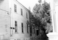
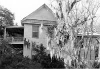
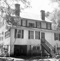
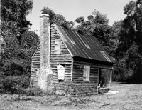
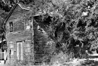
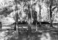
Old House Plantation, Clark Road. Slave Cabin - View of North (Side and Front) elevation. Edisto Island, S.C.;8" x 10" B/W photo. Box 11, Folder 2-3-10. One copy.
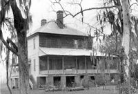
Middleton's Plantation (Chisolm's Plantation; The Launch), S.C. Hwy. 174. View of North (Rear) elevation. Edisto Island, S.C.;8" x 10" B/W photo. Box 11, Folder 2-3-9. One copy.
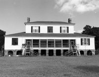
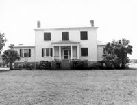
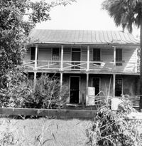
Middleton's Plantation (Chisolm's Plantation; The Launch), S.C. Hwy. 174. View of South (Front) elevation. Edisto Island, S.C.;8" x 10" B/W photo. Box 11, Folder 2-3-9. Two copies.
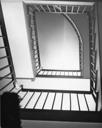
Halidon Hill Plantation (Quinby Plantation), Approximately 0.5 mile SE from Halidon Hill Lane and Cainhoy Road (S.C. Hwy 98). Main House, Interior View - Stair Landing leading to Attic. SW elevation. Huger, S.C.;8" x 10" B/W photo. Box 4, Folder 1-12-6. One copy.
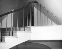
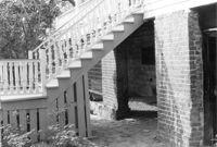
Halidon Hill Plantation (Quinby Plantation), Approximately 0.5 mile SE from Halidon Hill Lane and Cainhoy Road (S.C. Hwy 98). Main House, Interior View - Staircase, looking up. Huger, S.C.;8" x 10" B/W photo. Box 4, Folder 1-12-6. One copy.
Halidon Hill Plantation (Quinby Plantation), Approximately 0.5 mile SE from Halidon Hill Lane and Cainhoy Road (S.C. Hwy 98). Main House - View of NW (Side and Rear) elevation. Huger, S.C.;8" x 8" B/W photo. Box 4, Folder 1-12-6. One copy.
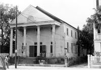
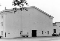
Guild Hall (Church of the Holy Family) - Barrows Historic District. View of Front. Moncks Corner, S.C.;6.5" x 9.5" B/W photo. Box 2, Folder 1-1-1. Three copies.
Halidon Hill Plantation (Quinby Plantation), Approximately 0.5 mile SE from Halidon Hill Lane and Cainhoy Road (S.C. Hwy 98). Main House, Interior View - Mantle. Huger, S.C.;8" x 8" B/W photo. Box 4, Folder 1-12-6. One copy.
Village Store and Blacksmith Shop, ca. 1873. View of NW (Front and Side) elevation. Cainhoy, S.C.;6.5" x 9.5" B/W photo. Box 4, Folder 1-12-3. One copy.
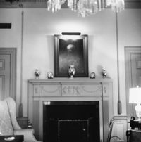
San Souci House, 206 San Souci Street. Detail View of Front Stairs. SW (Front and Side) elevation. Charleston, S.C.;6.5" x 10" B/W photo. Box 8, Folder 2-1-149. One copy.
Old Lincolnville Town Hall (Williams Graded School), near intersection of East Randolph Street and East Pinckney Street. View of interior. Lincolnville, S.C.;10" x 6.5" B/W photo. Box 17, Folder 2-15-2. Three copies.
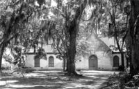
Christ Church Episcopal - Adams Run, State Highway 174. View of South (Side) elevation. Hollywood, S.C.;6.5" x 10" B/W photo. Box 16, Folder 2-11-12. Three copies.
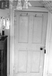
Seaside Plantation (Locksley Hall), off of Cypress Bottom Road. Interior View - 3rd Floor, West Bedroom. Detail of door, West elevation. Edisto Island, S.C.;5" x 7" B/W photo. Box 11, Folder 2-3-12. One copy.
St. Andrews Episcopal Church (Old St. Andrews Parish Church), 2604 Ashley River Road. View of South (Side) elevation. Charleston, S.C.;2" x 3" B/W photo. Box 14, Folder 2-9-7. One copy.
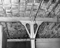
S.C. Railroad Car Shop (AAA Downtown Storage), 44 Line Street. Interior View - Detail of Support Beam. Charleston, S.C.;8" x 10" B/W photo. Box 18, Folder: Charleston: 44 Line Street, South Carolina Car Shop. One copy.
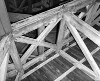
S.C. Railroad Car Shop (AAA Downtown Storage), 44 Line Street. Interior View - Unidentified Detail. Charleston, S.C.;8" x 10" B/W photo. Box 18, Folder: Charleston: 44 Line Street, South Carolina Car Shop. One copy.
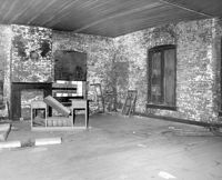
S.C. Railroad Car Shop (AAA Downtown Storage), 44 Line Street. Interior View - Unidentified Room. Charleston, S.C.;8" x 10" B/W photo. Box 18, Folder: Charleston: 44 Line Street, South Carolina Car Shop. One copy.
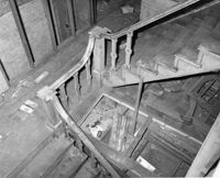
S.C. Railroad Car Shop (AAA Downtown Storage), 44 Line Street. Interior View - Detail of Staircase. Charleston, S.C.;8" x 10" B/W photo. Box 18, Folder: Charleston: 44 Line Street, South Carolina Car Shop. One copy.
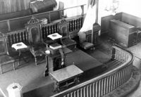
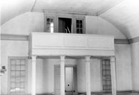
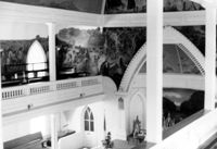
Central Baptist Church, 26 Radcliffe Street. Interior View - Upper Balcony and Chancel. SE (Front and Side) elevation. NOTE: Original print is out of focus. Charleston, S.C.;6.5" x 10" B/W photo. Box 9, Folder 2-1-156. One copy.
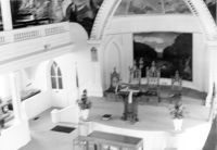
Central Baptist Church, 26 Radcliffe Street. Interior View - Altar and Pulpit. SE (Front and Side) elevation. NOTE: Original print is out of focus. Charleston, S.C.;6.5" x 10" B/W photo. Box 9, Folder 2-1-156. One copy.
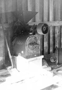
Fairlawn Plantation (Hugh Rose Plantation), Off of Guerins Bridge Road, adjacent to the Francis Marion National Forest. View of Corn Sheller.;10" x 6.5" B/W photo. Box 19, Folder: Charleston County: Christ Church: Fairlawn Plantation. One copy.
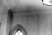
Central Baptist Church, 26 Radcliffe Street. Interior View - Detail of Vestibule Ceiling. NE (Rear and Side) elevation. Charleston, S.C.;6.5" x 10" B/W photo. Box 9, Folder 2-1-156. One copy.
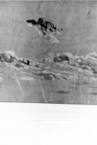
Central Baptist Church, 26 Radcliffe Street. Interior View - Detail of Balcony Mural. NE (Rear and Side) elevation. Charleston, S.C.;10" x 6.5" B/W photo. Box 9, Folder 2-1-156. One copy.