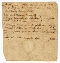
A statement certifying the purchase of enslaved persons by Benjamin Allston at the sale of Mr. George Heriot. The names of the enslaved persons purchased are: Philis and her two children Corkey and Peg, Fortune (a carpenter) and his wife Elsey and child Primus. Also includes a notation that Sibbey, the little daughter of Lydia, was bid off the same day by Robert Withers and given to Benjamin Allston.
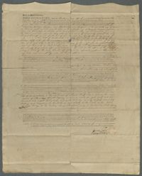
A power of attorney document stating that Matthew Bryan of Netherton in England appoints John Ball from South Carolina his attorney. Matthew Bryan outlines attorney responsibilities which includes overseeing all financial accounts in the United States.
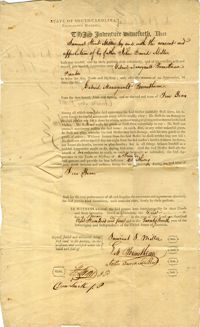
An indenture between Richard Dennis, William Calhoun, Robert Flemming, and John Williamson for the sale of a lot of land on the south side of Hasell St. in Charleston, South Carolina.
Samuel Stent Miller apprenticed himself to Gabriel Manigault Bounetheau, a Charleston (S.C.) printer, for a period of five years. Gabriel Manigault Bounetheau was a Justice of the Peace, Clerk of Council, and a printer with an office at 3 Broad Street, according to the Charleston City Directory of 1806.
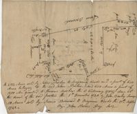
"Jonathan Burnbridge 310 acres certified for him the 24th day of December 1805. Pursuant to a warrant from Artemar B. Darby D. S. G. dated the 20th day of December 1805 having admeasured and laid out unto Jonathan Bunbridge a tract of land containing 310 acres situated in Charleston District bounded by a lain [sic] running NW and NW by land of Ralph Izard NE on land of William Stephens NE and E on land not known and by all other lines on land of Doctor William Stephens and hath such form and marks as the above plat represents Surveyed the 21 day of December 1805 Michael Byrne Dep Surveyor." Names associated with this plat are Jonathan Darby Bunbridge, B. Artemar, Ralph Izard, William Stepens, Dr. William Stephens, and Michael Byrne. Notable geographic locations include St. Bartholomew’s Parish.
Plat of 419 acres near Goose Creek sold to Benjamin Wood by John Parker. Only the trees located on the property line and names on neighboring property owners are included. Names associated with this plat are John Parker, Benjamin Wood, Thomas Barker, John Barley, James Boswood, Benjamin Woods, John Stevens, Thomas Hodson, I. Drayton, Thomas Mell, and Ben Godin.
Copy of a plat of 500 acres originally laid out to John Smith, now (1805) belonging to Alexander Bower as nephew and heir to the grantee. Details include swamps, surrounding lands, and trees. Names associated with this plat are Alexander Bower, John Smith, F. Bremar, William Moultrie, Sarah Blakeway, William Cattle, and Henry Crum.
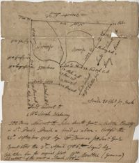
Plat of Hopewell Plantation with surrounding lands owned by several people, shows the Edisto River and an unnamed settlement, labels the land in the center as uncleared land while swamps, roads, rivers and trees surround it. Acreage unclear. Names associated with this plat are Baring, Branford, Mellechamp, Colonel W. Hayne and Arthur Middleton. Notable geographic locations are St. Paul's Parish, Edisto River, and Willtown Road.