This nineteen-page typed document was created for tour guides in the seven-block area of Historic Charleston Foundation's Ansonborough Rehabilitation Project.
This twelve-page typed document is a draft of material used for fundraising efforts by Historic Charleston Foundation, using the success of the Ansonborough Rehabilitation Project as an example of work accomplished by the Foundation.
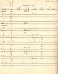
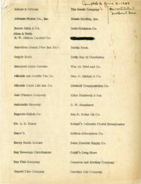
This 13-page typed document details information about the Ansonborough neighborhood, specific properties within it, and Historic Charleston Foundation's fundraising efforts to be used for its rehabilitation.