Search
« Previous |
101 - 200 of 4,227
|
Next »
Search Results
Description:
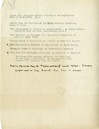
"Items for a two page special feature" on the "This is Charleston" exhibit.
Description:
Results of the off-street parking facilities survey in Mrs. Harry M. Rubin's report.
Description:
Document with a list of names and addresses, the purpose of which is not indicated. May be mailing list for Whitelaw Letter 2.
Description:
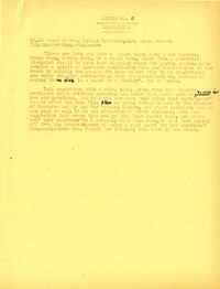
Statement regarding the Civic Services Committee's efforts regarding war memorials in Charleston.
Description:
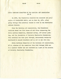
Description and index of Civic Services Committee materials that were taken from Carolina Art Association and incorporated into the files of what became Historic Charleston Foundation. Also includes a list of materials "now on deposit at SC Historical Society," and the finding aid to the Civic Services Committee records that are still held at the Gibbes Museum of Art.
Description:
Community Development Council document listing new personnel, Board of Governors, technical section, and membership.
Description:
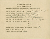
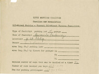
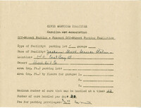
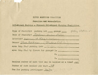
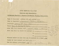
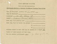
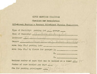
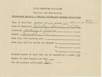
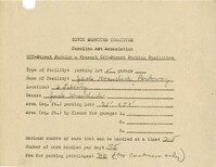
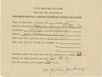
Off-street parking facilities survey filled out for Taud M. Esso Station.
Description:
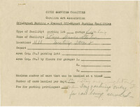
Off-street parking facilities survey filled out for Hood-Myers Electric Co.
Description:
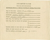
Off-street parking facilities survey filled out for Pure Service Station.
Description:
Off-street parking facilities survey filled out for Scobies Poultry Store.
Description:
Off-street parking facilities survey filled out for George Street Parkway.
Description:
Off-street parking facilities survey filled out for Brown's Parkway.
Description:
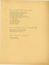
Document listing the number and size of prints of photographs.
Description:
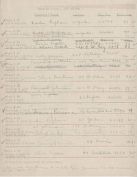
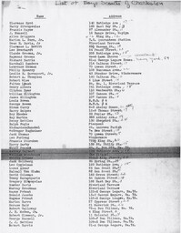
List of traffic count locations, checkers' names, address, telephone number, and troop number.
Description:
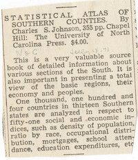
Newspaper clipping regarding the "Statistical Atlas of Southern Counties" by Charles S. Johnson.
Description:
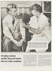
Clipping of article entitled "30 College students and Mrs. Roosevelt frankly talk over today's problems."
Description:
Off-street parking facilities survey filled out for Academy parking lot.
Description:
Article entitled "Babson Says New Type Houses, Better City Planning Ahead" regarding post-war housing and city planning.
Description:
Article entitled "Relaxation of Zoning Ordinance Sought for the Duration Only" regarding city zoning regulations.
Description:
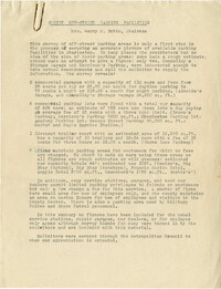
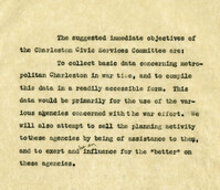
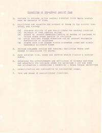
Document regarding the objectives of the Civic Services Committee.
Description:
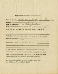
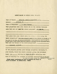
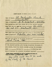
Church owned property questionnaire filled out for St. Andrew's Lutheran Church.
Description:
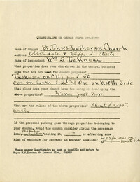
Church owned property questionnaire filled out for St. John's Lutheran Church.
Description:
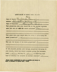
Church owned property questionnaire filled out for Unitarian Church of Charleston, SC.
Description:
Church owned property questionnaire filled out for Second Presbyterian Church.
Description:
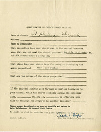
Church owned property questionnaire filled out for St. Phillip's Church.
Description:
Blank architectural survey questionnaire.
Description:
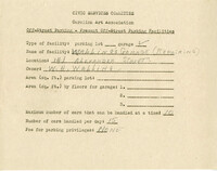
Off-street parking facilities survey filled out for Walling's Garage (Repairing).
Description:
Off-street parking facilities survey filled out for Jackson Street Service Station.
Description:
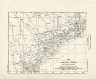
Topographic map of Charleston-Savannah by the U.S. Coast and Geodetic Survey.
Description:
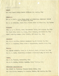
Attendance list for a CSC meeting on June 9 [1949].
Description:
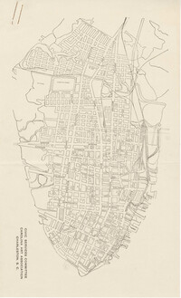
Map of the Charleston peninsula.
Description:
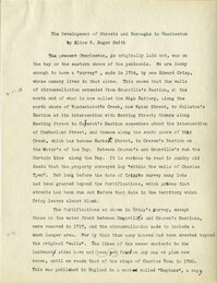
Draft of article entitled "The Development of Streets and Boroughs in Charleston" by Alice R. Huger Smith, written for the "This is Charleston" exhibit.
Description:
List of enlarged photographs of Charleston by Frances Benjamin Johnston.
Description:
"Purpose and Objects" of the Community Development Council (committee assignments list fixed to back of page one).
Description:
"Organization of Community Development Council" listing members of the Advisory Committee on Requirements for New Personnel.
Description:
List of names for invitation to the Community Development Council.
Description:
Map of area bounded by Liberty, King, George, and St. Philip Street.
Description:
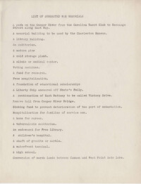
List of suggested war memorials for Charleston.
Description:
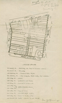
Map of area bounded by Hasell, Meeting, King and Market Street.
Description:
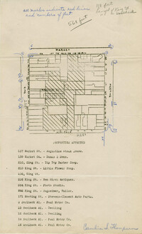
Map of area bounded by Horlbeck Alley, King, Market, and Meeting Street.
Description:
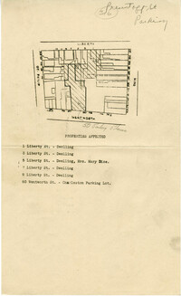
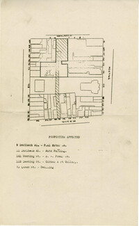
Map of area bounded by Wentworth Street, St. Philip Street, Liberty Street, and King Street.
Description:
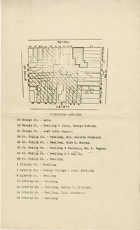
Map of area bounded by George Street, King Street, Liberty Street, and St. Philip Street.
Description:
Map of area bounded by Horlbeck Street, Meeting Street, and Queen Street.
Description:
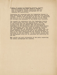
Document summarizing a letter to the Commanding General, Eastern Defense Command, from Captain James F. Reeves regarding the use of photographs of the Charleston area for the exhibit.
Description:
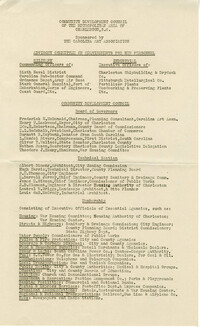
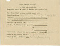
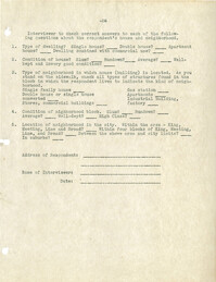
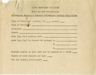
Blank "Off-Street Parking Questionnaire."
Description:
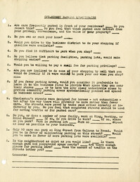
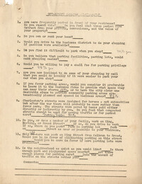
Objectives for an off-street parking plan.
Description:
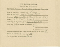
Off-street parking facilities survey filled out for Navy Shore Patrol.
Description:
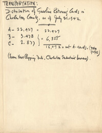
Document regarding transportation in Charleston County.
Description:
Draft of article entitled "Charleston Architectural Story" by Samuel Gaillard Stoney, written for the "This is Charleston" exhibit.
Description:
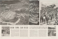
Clipping "Boom Town: San Diego."
Description:
List of Charleston photographs by Frances Benjamin Johnston.
Description:
Notes from "City Planning, Why and How" by Harold MacLean Lewis.
Description:
Map of area bounded by George, King, Calhoun, and St. Philip Street.
Description:
Map of area bounded by Wentworth, King, Beaufain, and St. Philip Street.
Description:
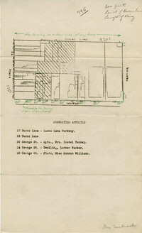
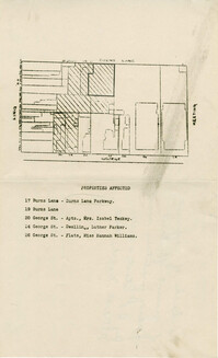
Map of area bounded by Burns Lane, George, Meeting, and King Street.
Description:
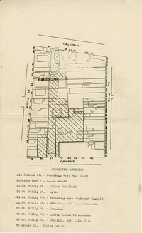
Map of area bounded by Society, Meeting, Wentworth, and King Street.
Date:
1940s
Description:
Article entitled "200,000 Living in Metropolitan Charleston."
Description:
Notes on preservation of historic buildings in England lecture by Mr. Underwood.
Description:
Notes from "Regional and Town Planning" by W.H. McLean.
Description:
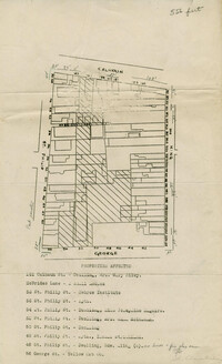
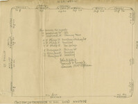
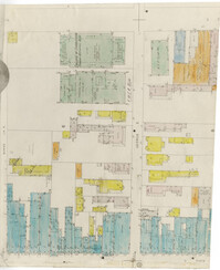
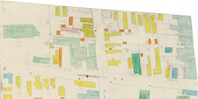
Color-coded map of area between George Street and Burns Lane, where they meet King Street.
Description:
Color-coded map of area between Society Street and Wentworth Street at Meeting Street..
Description:
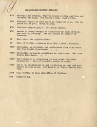
Assignment of tasks to complete traffic studies.
Description:
Disposition by the Community Development Council of listener suggestion about crowded buses in Charleston.
Description:
Disposition by the Community Development Council of two listener suggestions regarding the provision on trailer park camps.
Description:
Disposition by the Community Development Council of listerner suggestion regarding transportation.
Description:
Disposition by the Community Development Council of listener suggestion regarding housing for war workers.
Description:
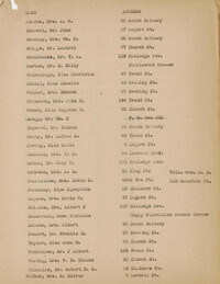
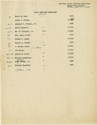
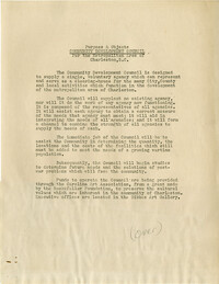
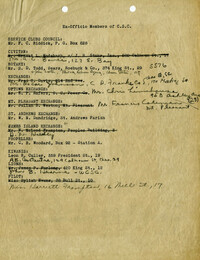
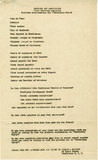
Ex-Officio membership list for the Civic Services Committee.
Description:
Off-street parking facilities survey filled out for Goldman's Service Station.
Description:
Off-street parking facilities survey filled out for Condon's Filling Station.
Description:
Off-street parking facilities survey filled out for Francis Marion Hotel.
Description:
Church owned property questionnaire filled out for St. Michael's Church.
Description:
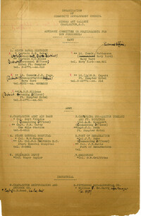
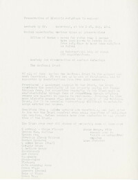
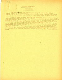
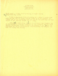
List of individuals proposed to become members of the Charleston Civic Services Committee.
Description:
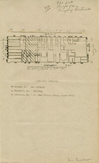
Map of area bounded by George Street, King Street, Burns Lane, and Meeting Street.
Description:
Map of area bounded by Calhoun Street, King Street, George Street, and St. Philip Street.
Description:
Business questionnaire for "Charleston Grows."
Description:
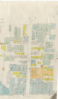
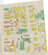
Color-coded map of area around Vanderhorst Street, near a police station and St. Paul's Episcopal Church.
Description:
Color-coded map of area bounded by Wentworth Street, Coming Street, George Street, and Glebe Street.
Description:
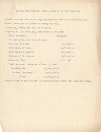
Document entitled "Information from Mr. James Altman as to Tax Structure."
Description:
Map of area bounded by Wentworth Street, St. Philip Street, Beaufain Street, and King Street.
Description:
Off-street parking facilities survey filled out for Charleston Parking Lot on 80 Wentworth Street.
Description:
Off-street parking facilities survey filled out for Firestone Service Station.
Description:
Off-street parking facilities survey filled out for Jack Krawcheck Parkway.
Description:
Off-street parking facilities survey filled out for Misereudino Motor Co.
Description:
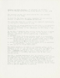
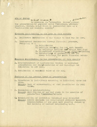
Outline (draft) describing the aim of the architectural survey, elements contributing to the loss of buildings, elements contributing to the preservation of historic buildings, features of the present trend of preservation, the inventory procedure, zoning, legal aspects, and financial aspects of preservation.
Description:
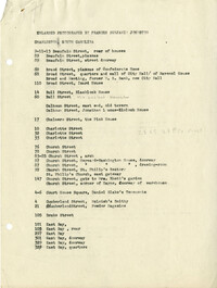
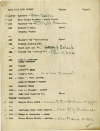
List of King Street merchants (east side), with worker assignments.
Description:
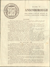
This four-page brochure includes background information on the Ansonborough Rehabilitation Project and Revolving Fund, photographs and information about Ansonborough homes, and a map of Ansonborough. Homes listed include 40 Society Street; 42 Society Street; 44 Society Street; 56 Society Street; 66 Anson Street; 63 Anson Street; 71 Anson Street; 72 Anson Street; 55 Laurens Street; 48 Laurens Street; 332 East Bay Street; and 329 East Bay Street.
Description:
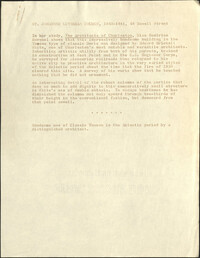
This one-page typed document discusses the historical background and describes the architecture of the building at 48 Hasell Street, St. Johannes Lutheran Church. The unknown writer references Beatrice Ravenel's book, The Architects of Charleston.
Description:
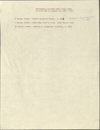
This one-page typed document provides ownership and approximate dates for 5 George Street, 7 George Street, and 45 Hasell Street.
Description:
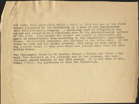
This half-page typed document discusses the Ansonborough Area Rehabilitation Program, the Revolving Fund, and restrictive covenants. The architecture of the Chancognie House at 48 Laurens Street and the home's current owner are also discussed.
Description:
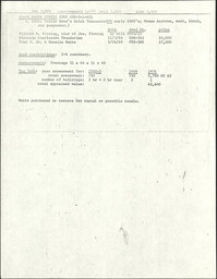
This one-page typed document provides financial and ownership history for 48 and 50 Anson Street.
Description:
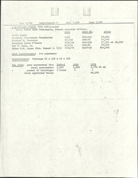
This one-page typed document provides financial and ownership history for 5 Alexander Street.
Description:
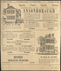
Advertisement for Ansonborough homes for sale in the News and Courier. Homes advertised include 61 Laurens Street, 22 Wentworth Street, 32 Society Street, 45 Hasell Street, 34 Anson Street, 5 George Street, 38 Anson Street, 24 Wentworth Street, and 74 Anson Street.
Description:
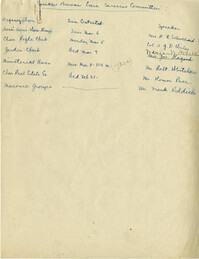
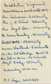
List of speaking engagement assignments
Description:
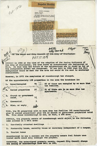
This two-page document describes A. C. Logan's request to subdivide 42 Hasell Street into seven apartments and lists the petitioners opposed to the request, which was ultimately denied.
Description:
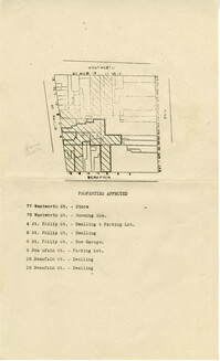
Six maps conveying plans to beautify Ansonborough, showing the footprints of buildings and annotated to indicate the status of buildings, traffic flow, and scenarios that would result from the Ansonborough Rehabilitation Project.
Description:
In this petition, Ansonborough property owners request a change in Ansonborough zoning from DR-1 to STR.
Description:
Boy Scouts of Charleston membership list with addresses.
Description:
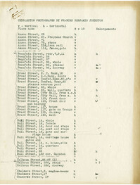
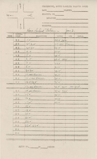
Blank off-street parking form for present off-street parking facilities attached to area list (List of areas 1-13).
Description:
Traffic count papers for Charleston, SC, with tally marks on them.
Description:
Blank Off-Street Parking Questionnaire.