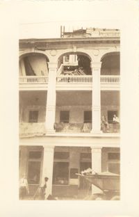
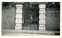
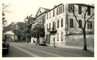
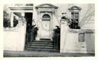
This one-page typed document discusses the historical background and describes the architecture of the building at 48 Hasell Street, St. Johannes Lutheran Church. The unknown writer references Beatrice Ravenel's book, The Architects of Charleston.
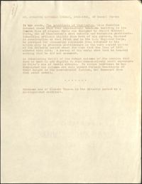
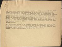
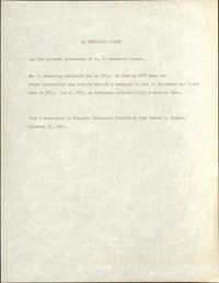
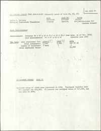
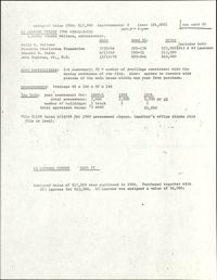
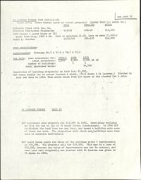
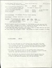
This half-page typed document discusses the Ansonborough Area Rehabilitation Program, the Revolving Fund, and restrictive covenants. The architecture of the Chancognie House at 48 Laurens Street and the home's current owner are also discussed.
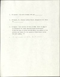
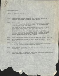
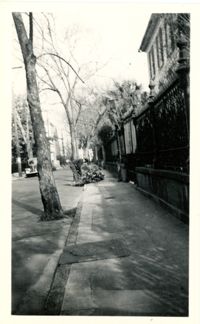
One-page typed document including historical and architectural information for 50 Laurens Street; 48 Hasell Street, St. Johannes Lutheran Church; and 54 Hasell Street, former home of Colonel William Rhett. St. Katharine's Convent is written in as the fourth property with no accompanying information.
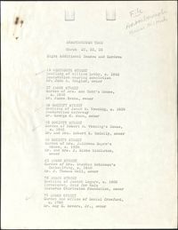
In this one-page typed document eight houses and gardens are added to the walking tour through the Ansonborough Neighborhood: 19 Wentworth Street, 57 Anson Street, 46 Society Street,43 Society Street, 63 Anson Street, 75 Anson Street, and 79 Anson Street. An approximate date of when the buildings on the property were built, as well as ownership information, is included.
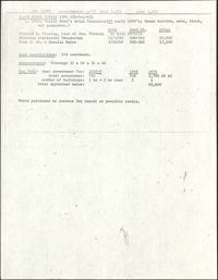
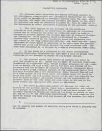
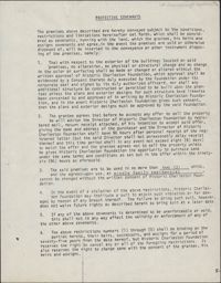
This one-page typed document provides stipulations for properties under the Historic Charleston Foundation's Protective Covenants agreement, prior to 1977 and after 1965.
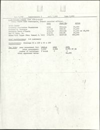
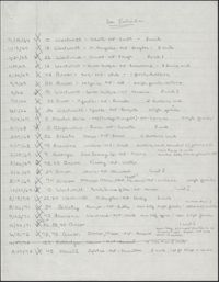
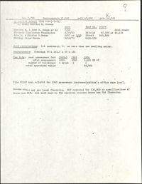
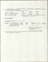
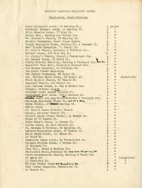
This two-page, handwritten document lists several properties in the Ansonborough neighborhood. The document title indicates that the properties listed were under use restrictions.
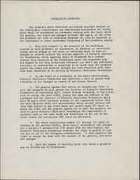
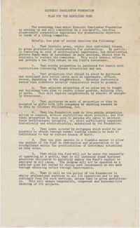
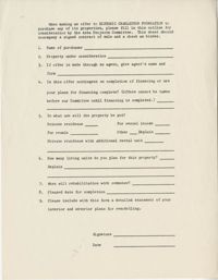
This one-page typed document is an application for interested buyers to submit to Historic Charleston Foundation to purchase a property owned by the Foundation.
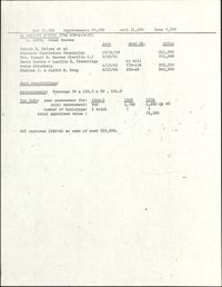
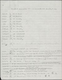
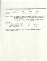
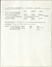
This one-page handwritten document lists several properties in the Ansonborough neighborhood. The document title indicates that the properties listed were under standard covenants with no restrictions on density or use.
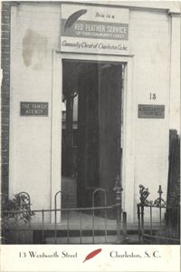
A photograph of the doorway leading into 13 Wentworth Street printed on a publication for the Red Feather Service of the Community Chest of Charleston Co. Inc.
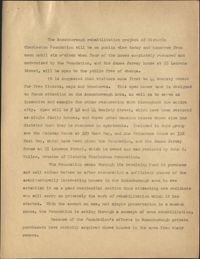
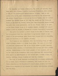
This two-page typed document describes a tour of Ansonborough Rehabilitation Project houses, including: 55 Laurens Street, the James Jervey House; 44 Society Street; 42 Society Street; 329 East Bay Street, the Gadsden House; and 332 East Bay Street, the Primerose House. Also includes information about other houses sold in Ansonborough, including 43 Society Street and houses on Laurens and Wentworth Streets.
This three-page typed document describes a tour of Ansonborough Rehabilitation Project houses, including: 42 Society Street; 44 Society Street; 329 East Bay Street, the Gadsden House; 332 East Bay Street, the Primerose House; and 55 Laurens Street, the James Jervey House. Includes information about the Ansonborough Rehabilitation Project committee and its members.
This one-page typed document, is a compilation of notes from an investigation into the ownership history of the property at 45 Hasell Street, tracing the property deed back to 1837.
In this one-page typed document, Historic Charleston Foundation Director Mrs. S. Henry Edmunds provides a thorough description of 75 Anson Street, The Joseph Legare House, and the accompanying outbuildings, all of which were for sale at the time. Recommended renovations for the property and buildings are included.
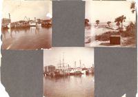
Three photographs on page. Top left and bottom: View from the Cooper River of the piers and boats on the Charleston waterfront behind the U.S. Customhouse. The Customhouse can be seen in the background as well as Market Street buildings. Top right: Unidentified beach scene, possibly Isle of Palms.
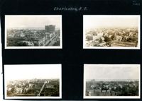
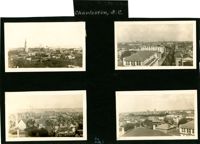
Four aerial views of Charleston looking across the peninsula. Top left: Looking northeast, possibly from St. Michael’s Church, showing Broad Street and the area to its north bounded by East Bay Street, and possibly Queen Street. Cars are parked along the street. Landmarks include the Confederate Home and its rear dormitory apartments, People's Building, Old Exchange Building, and the corner of Broad and Church Streets showing the Bank of South Carolina Building (50 Broad Street) before it was restored. A faint view of the U.S. Customhouse is at the far left. Top right: Looking southeast, possibly from the Francis Marion Hotel, with Meeting Street bisecting the view at a diagonal. Landmarks include the U.S. Customhouse, Charleston Hotel, People’s Building, and St. Philip’s Church. Bottom left: Looking south on King Street, possibly from the Francis Marion Hotel, showing King Street from approximately 360 King down to the bend near Market Street, and the view east of King Street. Vehicles can be seen on King Street. Landmarks include the Masonic Temple Building (270 King Street), the tower of the Peoples First National Bank Building (also known as the Hirsh Israel Building, 275 King Street), and the Hotel Calhoun (238-242 King Street). Bottom right: Looking southwest, possibly from St. Michael’s Church, toward James Island. Landmarks include the Fort Sumter House (1 King Street), Col. John Ashe House (32 South Battery), rear of First Scots Presbyterian Church (57 Meeting Street), Miles Brewton House (27 King Street), and the north elevation of the John E. Poyas House (69 Meeting Street).
Four aerial views of Charleston looking across the peninsula. Top left: Looking northeast, possibly from City Hall. Landmarks include the rear dormitory apartments of the Confederate Home, St. Philip's Church, and the U.S. Customhouse. Top right: Looking north on Meeting Street, possibly from St. Michael’s Church, and showing the view west of Meeting Street. Vehicles, including a trolley car, can be seen on the street. Landmarks include the Timrod Hotel, Mills House Hotel, Fireproof Building, Circular Church, and Francis Marion Hotel (in the distance). Bottom left: Looking east on Calhoun Street, possibly from the Francis Marion Hotel, and showing the view east and west of Calhoun Street. Vehicles can be seen on the street. Landmarks include the Calhoun Monument in Marion Square, Citadel Square Baptist Church, and Emanuel A.M.E. Church. Bottom right: Looking north possibly from St. Michael’s Church. Landmarks include St. John's Lutheran Church, Unitarian Church, Grace Episcopal Church, and the Charleston Orphan House (in the distance at right).
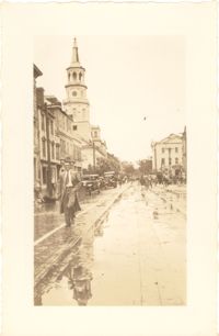
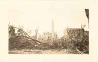
Photograph of Church Street, looking south from the corner of Broad Street at 49 Broad (right foreground), showing the scene on the street after the tornadoes of September 29, 1938. Fallen tree lies across the street; debris and water cover the street. Onlookers are on the street. 105 Church and 107 Church can also be seen.
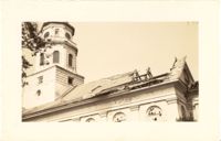
Photograph of Lamboll Street elevation of 19 King Street [Thomas Lamboll House] after the tornadoes of September 29, 1938, showing the damage done to the piazzas and roof. Men are standing on the roof.
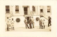
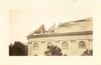
Photograph of City Hall after the tornadoes of September 29, 1938, showing the damage done to the building. Men stand on the landing at the entry to the building.
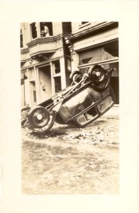
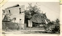
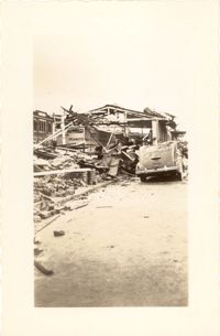
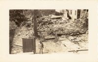
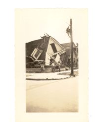
Photograph of wooden building demolished by the first tornado of September 29, 1938. The photograph is marked with a small green X to show the location of the body of a man killed by the tornado. Handwritten on back of photo: "1st tornado came in by Battery near Miller's junk yard - Laurence [Laurens?] Street. This shed is on top of small Negro house. The Negro was dead when found. Sept. 29, '38."
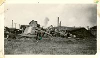
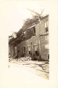
Photograph of the Viohl Hay & Grain warehouse demolished by the tornado of September 29, 1938. Located at the northwest corner of Vendue Range and Concord Street (address 14 Vendue Range). Portion of the building across the street can be seen at left. Steeple of St. Michael's Church in the distance at right. Handwritten on back of photo: "Taken in front of the Clyde Line Steam Ship Co. on Concord Street. Vohls Grain Place. Tornado - Sept. 29, 1938. In distance is St. Michael's Church steeple."
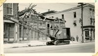
Photograph of the I.M. Pearlstine Building (203 East Bay Street), located on the southwest corner of East Bay Street and Street, after the tornado of September 29, 1938, showing the damage done to the building. Also shows 205 East Bay Street, located on the northwest corner of East Bay and Cumberland. "Bay City" heavy equipment vehicle (excavator?) parked in front of building. Pedestrian and a street worker walking on the sidewalk; repairman on the utility pole on the street corner.
Photograph of Broad Street, looking west, showing the scene on the street after the tornadoes of September 29, 1938. South side of the 60 block of Broad Street in foreground; St. Michael's Church and the Charleston County Courthouse in the background. Onlookers and vehicles are on the street.
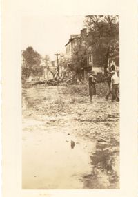
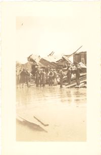
Photograph showing several dwellings in Fiddlers Green damaged or destroyed by the tornado of 1938. Handwritten on back of photo: "1st tornado hit Fiddlers Green, Negro section by Ashley Bridge, Hilly Street [should be Lilly Street], Sept. 29, '38."
Photograph of a house on Fishburne Street demolished by the tornado of 1938. Neighboring house in view at left. (Both houses would have been on the north side of the 200 block of Fishburne Street.) Handwritten on back of photo: "2nd tornado on Fishburne Street near President Street. Demolished about 60 houses here. This 2nd tornado damage about $6,000,000. 300 houses condemned. Sept. 29, '38."
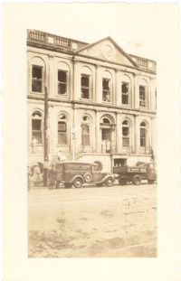
Photograph of the Charleston County Courthouse after the tornadoes of September 29, 1938, showing the damage done to the building. View of the corner elevation (Meeting Street and Broad Street). People who are standing inside the building at the second and third story windows can be seen. To the left of the Courthouse, the Hebrew Orphanage (88 Broad Street) is also in view.
Photograph of a commercial building on a Church Street corner after the tornadoes of September 29, 1938, showing the damage done to the building. Probably located at the corner of Church and North Market Street or South Market Street. Onlookers stand on sidewalk.
Photograph of Washington Square Park after the tornadoes of September 29, 1938, showing debris and fallen trees in the foreground; Washington Light Infantry monument in the middle; and the Meeting Street fire tower and Chalmers Street buildings in the background.
Photograph of City Hall after the tornadoes of September 29, 1938, showing the damage done to the building. Infantry patrolmen and other men stand in front of building.
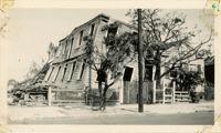
Photograph of the wreckage of the Calvary Baptist Church, an African-American church demolished by the tornado of September 29, 1938. Located at the corner of Sumter Street and Ashley Avenue; address may have been 387 Sumter Street. Handwritten on back of photo: "Old Negro church on Sumter Street, corner of Ashley Avenue. This was done by second tornado that hit 2 miles from the other one. Sept. 29, 1938."
Photograph of the I.M. Pearlstine Building on Cumberland Street, located between East Bay and State Street, after the tornadoes of September 29, 1938, showing the damage done to the building. Portion of signage is visible at the right of the photograph, "I.M." and "Budwe[iser]"; signage for "Rex" is also on building (at left). Onlookers stand among the debris on the street.
Photograph of First Scots Presbyterian Church [57 Meeting Street] after the tornadoes of September 29, 1938, showing the damage done to the building. The Nathaniel Russell House can be seen in the background. Cars are parked on the street in front of the church.
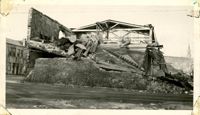
Photograph of the ruins of a building on King Street after the tornadoes of September 29, 1938. Shows the debris of a completely demolished structure and the damaged roof of the neighboring building. Based on newspaper accounts, this is probably the site of the Rectory of the Church of the Sacred Heart at King and Huger Streets. Three men stand on the sidewalk facing the debris; other men are standing on a pile of debris.
Looking east on Market Street after the tornadoes of September 29, 1938, showing the Market Sheds in ruins. A damaged car is parked along side of the debris. The Old Church of the Redeemer can be seen in the background.
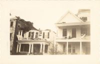
Photograph of 38 South Battery and 40 South Battery [Frederick Heinz Houses] and a portion of 42 South Battery, after the tornadoes of September 29, 1938, showing the damage done to the houses.
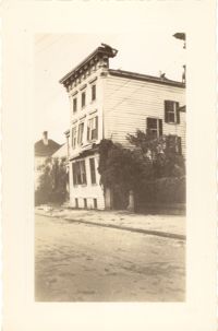
Photograph 19 King Street [Thomas Lamboll House] after the tornadoes of September 29, 1938, showing the damage done to the house. King Street elevation.
Photograph of City Hall after the tornadoes of September 29, 1938, showing the damage done to the building. Two trucks, including an Automatic Grocery truck, are parked in front of building. Onlookers are on the sidewalk in front of building; men stand at doorways and windows.
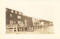
Photograph of the United Fruit Company dock after the September 29, 1938, tornadoes. (Based on Sanborn Maps, the dock was located at the foot of Laurens Street, Southern Railway Pier 2.)
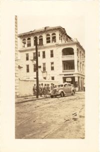
Photograph of the Timrod Hotel [ca. 101 Meeting Street], after the tornadoes of September 29, 1938, showing the damage done to the building. View of the hotel looking north on Meeting Street (southeast elevation). Infantry patrolmen stand on sidewalk by a car. Signage for Byars Drug Store is on the south elevation. [Note: The hotel was later demolished in the 1960s.]
Photograph of Broad Street, looking east at the 60 block, showing the scene on the street after the tornadoes of September 29, 1938. The Daniel Ravenel House (68 Broad Street), the Confederate Home, and the People's Building can be seen at the right; the Old Exchange Building is visible in the background. Onlookers, cars, and a person riding a bicycle are on the street.
Photograph of the Timrod Hotel [ca. 101 Meeting Street], after the tornadoes of September 29, 1938, showing the damage done to the building. East elevation. Men are sitting on the second story piazza ledge. Men stand on the sidewalk by a truck that is carrying debris. [Note: The hotel was later demolished in the 1960s.]
Looking northwest on Market Street from the U.S. Custom House on East Bay Street, after the tornadoes of September 29, 1938, showing damaged and ruined Market Sheds. Also shows the damaged buildings on North Market Street. Onlookers and cars are in the street. Partial view of ca. 225 East Bay Street (now gone) is on the left.
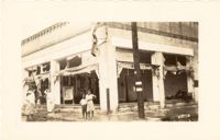
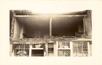
Photograph of the Sing Lee Laundry (133 King Street) after the tornadoes of September 29, 1938, showing the damage done to the building. Signs for the Robbins Bros. Circus (on Sept. 26) are posted in the windows.
Photograph of the ruins of a building, after the September 29, 1938, tornadoes. Based on newspaper accounts, it is probably the site of 45 State Street. Infantry patrolman stands in foreground.
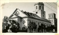
Photograph of St. Michael's Church after the first tornado of September 29, 1938, showing the damage done to the roof. Handwritten on back of photo: "Old historic St. Michael's Church, corner Broad Street and Meeting Street. Done by first tornado, Sept. 29, '38."
Photograph of the destruction of a house done by the tornadoes of September, 29, 1938. Based on newspaper accounts, the home was probably located in the Fiddlers' Green neighborhood near the Ashley River. Two men lean against the ruins while another man climbs a nearby telephone pole.
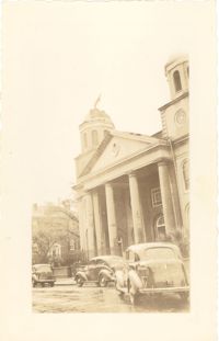
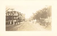
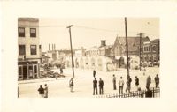
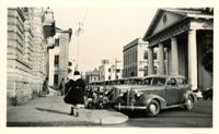
Scene on Meeting Street just south of the "Four Corners of Law" on Broad Street. Features the Federal Courthouse and Post Office and St. Michael's Church in foreground, and the County Courthouse and City Hall in background. Numerous cars are parked in front of the Federal Courthouse, with pedestrians on the sidewalk.
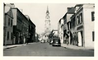
Looking north on Church Street from the northeast corner of Chalmers Street. Features buildings on the west side of the street: 129 Church, 131 Church, and the Dock Street Theater). Also in view are buildings on the east side of the street: 18 Chalmers Street, 132 Church Street, and St. Philip's Church). Cars are parked on the street.
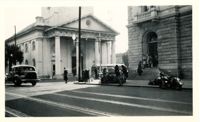
View of the intersection of Broad and Meeting Streets, featuring the Federal Courthouse and Post Office and St. Michael's Church. A car, motorcycle, and bus are on the street the street. Also shows pedestrian activity.
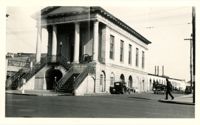
View of Market Hall, southwest elevation, including market sheds, and the corner of Market and Meeting Streets. Cars on street and pedestrian crossing the street. Cravens Delco Radio [store] on North Market Street at left.
Looking north on Legare Street at 22 Legare Street (Charles Elliott House), a portion of which can be seen in the foreground (right). Man gathering leaves on the sidewalk. Car parked in background.
Looking west on Tradd Street at the outbuildings of 32 Legare Street (Sword Gate House). West End Dairy truck parked on street. Pedestrian on sidewalk and person riding a bike on street.
Looking north on East Battery Street from near the bend at White Point Gardens. Pedestrian is walking by White Point Gardens. Louis Desaussure House (1 East Battery) at center; Missroon House (40 East Bay Street) in the distance.
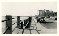
Looking west on Murray Boulevard from the bend at East Battery. Edge of White Point Gardens in view at right; Fort Sumter Hotel (now known as the Fort Sumter House at 1 King Street) in background. Cars on the road.
Looking west on Broad Street at 110 Broad Street (Bishop Northrop residence a/k/a William Harvey House a/k/a Ralph Izard House) and 114 Broad Street (Col. Thomas Pinckney House). Cars parked along the street.
Looking north on Church Street from Chalmers Street. Features buildings on the west side of the street: 127 Church, 129 Church, 131 Church, and the Dock Street Theater). Also in view are buildings on the east side of the street: 18 Chalmers Street, 132 Church Street, and St. Philip's Church). Cars are parked on the street.