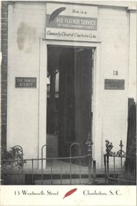
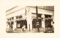
A photograph of the doorway leading into 13 Wentworth Street printed on a publication for the Red Feather Service of the Community Chest of Charleston Co. Inc.
A four-page typed document chronicling the history of the Ansonborough property from 1696 with Isaac Mazyck's Propietary Grant through the segmentation of the property beginning in 1759 through a purchase in 1904. The development of the various streets in the Ansonborough area and the building of houses is also discussed.
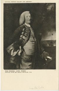
A post card printed for the National Portrait Gallery in London. On the front is a portrait of George, First Lord Anson (1697-1762); on the back is a brief biography of Anson by Philip Gosse.
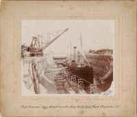
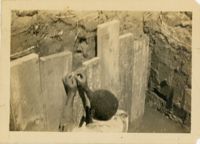
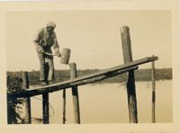
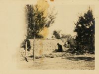
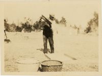
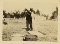
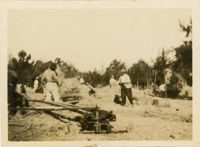
Still images found among the belongings of Henry T. Zacharias, a Charleston builder and contractor in the late 19th- and early-20th century. Zacharias built and/or repaired many notable buildings in Charleston. Includes photographs and one engraving of buildings on which he worked (or likely worked); photographs of battleships in dry dock at the Charleston Navy Yard; and a photograph of his gravesite at Magnolia Cemetery. (Note: Two of Mr. Zacharias's ledger books are in Special Collections at College of Charleston, 'Henry T. Zacharias Ledgers, 1905-1910.')
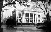
Photographs of Charleston buildings, streets, and other sites. Includes brief history of Charleston. Presumably published by A. Wittemann (New York); printed by The Albertype Co. (New York). [2] p., [48] leaves of plates. Measures 13 x 19 cm.
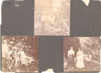
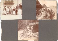
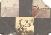
Three photographs on page. Top: Man and woman in a horse and buggy. Bottom left: Two men and two women riding on a horse and buggy; woman in the backseat is likely Sabina Elliott Wells (artist, designer, Newcomb potter). Bottom right: Two women standing on a lawn with children and a mule-drawn cart in background; woman on left is likely Sabina Elliott Wells.
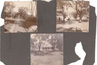
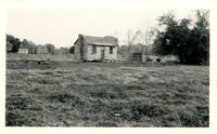
Three photographs on page. Top left: Allee on the grounds of plantation likely in Georgetown. Top right: Barn, carriages, and a mule on a Georgetown plantation. Bottom: Woman holding an infant in front of a dwelling on a Georgetown Plantation.
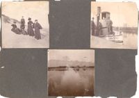
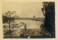
Three photographs on page. Top left: Four women and a man on a sand dune at an unidentified beach. Top right: Three men stand on the steamboat Emma A. Twiggs on the Pee Dee River. Bottom: View across the Pee Dee River.
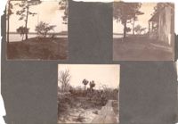
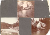
Three photographs on page. Top left: View of bluff on a river, likely the Pee Dee River. Top right: Bluff and dwelling on Pee Dee River. Bottom: Boardwalk on unidentified beach.
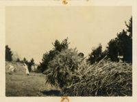
Three photographs on page. Top left: Five African-American hucksters with baskets of goods balanced on their heads standing under a balcony; the dresses of the three women standing above them on the balcony are also in view. Top right: Men in a mule-drawn cart riding by farm buildings on a Georgetown plantation. Bottom: Group of people and a dog picnicking on the rocks by a river, possibly at Flat Rock, N.C.
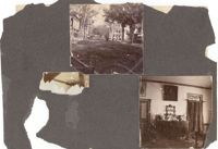
Two photographs on page. Top: View of Screven Street in Georgetown, South Carolina. The Georgetown County Courthouse is at left. Bottom: Interior room of unidentified house, featuring china hutch and other furnishings.
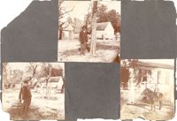
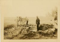
Three photographs on page. Top: Man stands by tree on the grounds of a plantation, likely in Georgetown; plantation structures or dwellings in background. Bottom left: Boy after hunting, holding his rifle in one hand and a dead bird in the other; plantation structures or dwellings in background. Bottom right: Boy seated on a mule in front a plantation dwelling.
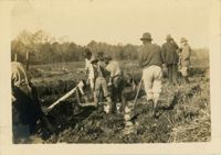
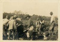
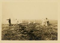
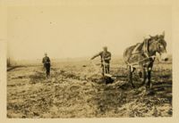
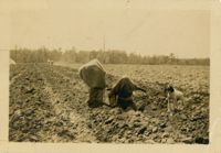
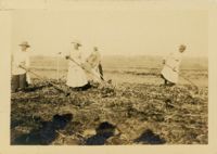
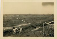
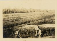
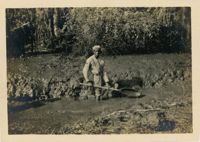
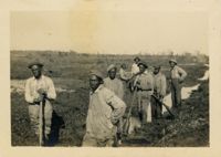
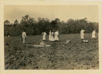
Three photographs on page. Top left and top right: Rice cultivation scenes, likely at a Georgetown plantation. White man looks on at African-American field workers threshing rice. Winnowing house at right in both photos; mill building at left in the top right photo. Bottom: Three men relaxing under a tent.
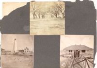
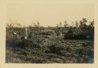
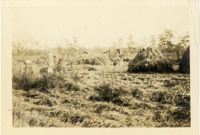
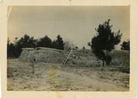
Three photographs on page. Top: Slave cabins along an allée on the grounds of a plantation likely in Georgetown. Bottom left: View of the Georgetown Lighthouse and dwelling. Bottom right: Woman and two men standing on the boardwalk in front of the dwelling adjacent to the Georgetown Lighthouse.
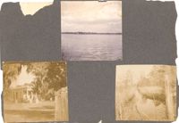
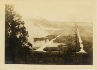
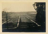
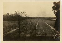
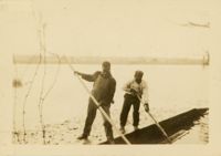
Three photographs on page. Top: View across a river. Bottom left: View of All Saints Episcopal Church; gravestone in foreground. Bottom right: View of a rice canal; portion of a rice trunk in foreground.
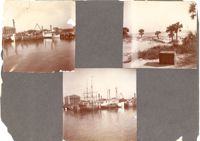
Three photographs on page. Top left and bottom: View from the Cooper River of the piers and boats on the Charleston waterfront behind the U.S. Customhouse. The Customhouse can be seen in the background as well as Market Street buildings. Top right: Unidentified beach scene, possibly Isle of Palms.
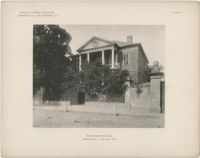
The folio, Examples of Colonial Architecture in Charleston, S.C. and Savannah, Ga., features photographic plates of some of the most important houses and buildings in Charleston and Savannah. Photographs include exterior views of the buildings, gates, and entrances, as well as interior views of fireplaces, mantels, doors, rooms, and ceilings. Compiled and photographed by Edward A. Crane and E.E. Soderholtz. Published in 1895 by the Boston Architectural Club (Boston, Mass.).
Photographs taken by Sabina Elliott Wells in 1898-1899. Wells was a Charleston artist and designer; she was also a Newcomb potter. Photographs include scenes in Charleston and the Lowcountry, in northwest South Carolina (Table Rock and vicinity), and in western North Carolina (Flat Rock and vicinity). Scans were derived from negatives donated to Historic Charleston Foundation. (Note: Wells's diaries from 1898-1899 that document some of her travels, including sites represented in these photographs, are at the South Carolina Historical Society, "Sabina E. Wells papers, 1886-1942.")
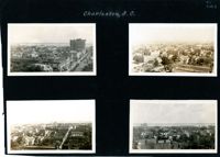
Four aerial views of Charleston looking across the peninsula. Top left: Looking northeast, possibly from St. Michael’s Church, showing Broad Street and the area to its north bounded by East Bay Street, and possibly Queen Street. Cars are parked along the street. Landmarks include the Confederate Home and its rear dormitory apartments, People's Building, Old Exchange Building, and the corner of Broad and Church Streets showing the Bank of South Carolina Building (50 Broad Street) before it was restored. A faint view of the U.S. Customhouse is at the far left. Top right: Looking southeast, possibly from the Francis Marion Hotel, with Meeting Street bisecting the view at a diagonal. Landmarks include the U.S. Customhouse, Charleston Hotel, People’s Building, and St. Philip’s Church. Bottom left: Looking south on King Street, possibly from the Francis Marion Hotel, showing King Street from approximately 360 King down to the bend near Market Street, and the view east of King Street. Vehicles can be seen on King Street. Landmarks include the Masonic Temple Building (270 King Street), the tower of the Peoples First National Bank Building (also known as the Hirsh Israel Building, 275 King Street), and the Hotel Calhoun (238-242 King Street). Bottom right: Looking southwest, possibly from St. Michael’s Church, toward James Island. Landmarks include the Fort Sumter House (1 King Street), Col. John Ashe House (32 South Battery), rear of First Scots Presbyterian Church (57 Meeting Street), Miles Brewton House (27 King Street), and the north elevation of the John E. Poyas House (69 Meeting Street).
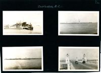
Four photographs on the page. Top left: Tugboat and other ships in a floating dry dock in the Charleston Harbor (possibly Charleston Shipbuilding). Top right: View of the Charleston waterfront from the Ashley River. Some of the landmark buildings visible in the background include St. Matthew's Church, Francis Marion Hotel, St. John's Lutheran Church, Unitarian Church, St. Philip's Church, People's Building, St. Michael's Church, and West Point Rice Mill. Bottom left: View of the Charleston waterfront from the Cooper River. Some of the landmark buildings visible in the background include Fort Sumter Hotel, St. Michael's Church, St. Philip's Church, U.S. Customhouse, and several wharves. Bottom right: Two cars on the Ashley River Bridge, one heading east and one heading west. View of the Charleston waterfront in the background.
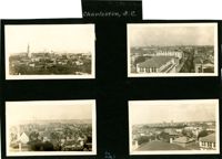
Four aerial views of Charleston looking across the peninsula. Top left: Looking northeast, possibly from City Hall. Landmarks include the rear dormitory apartments of the Confederate Home, St. Philip's Church, and the U.S. Customhouse. Top right: Looking north on Meeting Street, possibly from St. Michael’s Church, and showing the view west of Meeting Street. Vehicles, including a trolley car, can be seen on the street. Landmarks include the Timrod Hotel, Mills House Hotel, Fireproof Building, Circular Church, and Francis Marion Hotel (in the distance). Bottom left: Looking east on Calhoun Street, possibly from the Francis Marion Hotel, and showing the view east and west of Calhoun Street. Vehicles can be seen on the street. Landmarks include the Calhoun Monument in Marion Square, Citadel Square Baptist Church, and Emanuel A.M.E. Church. Bottom right: Looking north possibly from St. Michael’s Church. Landmarks include St. John's Lutheran Church, Unitarian Church, Grace Episcopal Church, and the Charleston Orphan House (in the distance at right).
Photograph of Church Street, looking south from the corner of Broad Street at 49 Broad (right foreground), showing the scene on the street after the tornadoes of September 29, 1938. Fallen tree lies across the street; debris and water cover the street. Onlookers are on the street. 105 Church and 107 Church can also be seen.
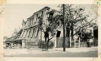
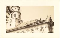
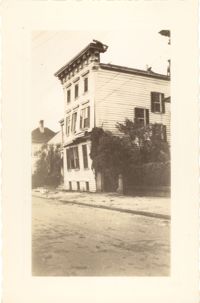
Photograph of Lamboll Street elevation of 19 King Street [Thomas Lamboll House] after the tornadoes of September 29, 1938, showing the damage done to the piazzas and roof. Men are standing on the roof.
Photograph of City Hall after the tornadoes of September 29, 1938, showing the damage done to the building. Men stand on the landing at the entry to the building.
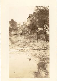
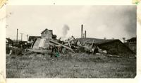
Photograph showing several dwellings in Fiddlers Green damaged or destroyed by the tornado of 1938. Handwritten on back of photo: "1st tornado hit Fiddlers Green, Negro section by Ashley Bridge, Hilly Street [should be Lilly Street], Sept. 29, '38."
Photograph of a house on Fishburne Street demolished by the tornado of 1938. Neighboring house in view at left. (Both houses would have been on the north side of the 200 block of Fishburne Street.) Handwritten on back of photo: "2nd tornado on Fishburne Street near President Street. Demolished about 60 houses here. This 2nd tornado damage about $6,000,000. 300 houses condemned. Sept. 29, '38."
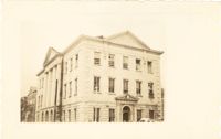
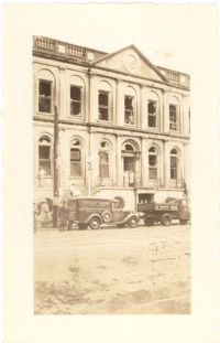
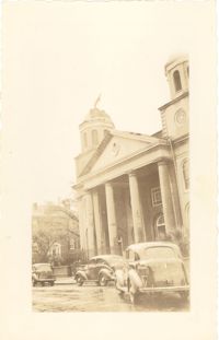
Photograph of the Charleston County Courthouse after the tornadoes of September 29, 1938, showing the damage done to the building. View of the corner elevation (Meeting Street and Broad Street). People who are standing inside the building at the second and third story windows can be seen. To the left of the Courthouse, the Hebrew Orphanage (88 Broad Street) is also in view.
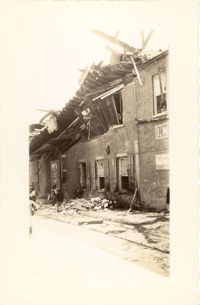
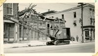
Photograph of a commercial building on a Church Street corner after the tornadoes of September 29, 1938, showing the damage done to the building. Probably located at the corner of Church and North Market Street or South Market Street. Onlookers stand on sidewalk.
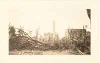
Photograph of Washington Square Park after the tornadoes of September 29, 1938, showing debris and fallen trees in the foreground; Washington Light Infantry monument in the middle; and the Meeting Street fire tower and Chalmers Street buildings in the background.
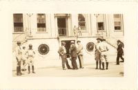
Photograph of City Hall after the tornadoes of September 29, 1938, showing the damage done to the building. Infantry patrolmen and other men stand in front of building.
Photograph of City Hall after the tornadoes of September 29, 1938, showing the damage done to the building. Two trucks, including an Automatic Grocery truck, are parked in front of building. Onlookers are on the sidewalk in front of building; men stand at doorways and windows.
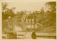
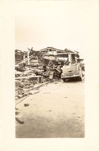
Photograph of the United Fruit Company dock after the September 29, 1938, tornadoes. (Based on Sanborn Maps, the dock was located at the foot of Laurens Street, Southern Railway Pier 2.)
Photograph of the Timrod Hotel [ca. 101 Meeting Street], after the tornadoes of September 29, 1938, showing the damage done to the building. East elevation. Men are sitting on the second story piazza ledge. Men stand on the sidewalk by a truck that is carrying debris. [Note: The hotel was later demolished in the 1960s.]
Looking northwest on Market Street from the U.S. Custom House on East Bay Street, after the tornadoes of September 29, 1938, showing damaged and ruined Market Sheds. Also shows the damaged buildings on North Market Street. Onlookers and cars are in the street. Partial view of ca. 225 East Bay Street (now gone) is on the left.
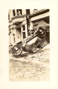
Photograph of wooden building demolished by the first tornado of September 29, 1938. The photograph is marked with a small green X to show the location of the body of a man killed by the tornado. Handwritten on back of photo: "1st tornado came in by Battery near Miller's junk yard - Laurence [Laurens?] Street. This shed is on top of small Negro house. The Negro was dead when found. Sept. 29, '38."
Photograph of the Viohl Hay & Grain warehouse demolished by the tornado of September 29, 1938. Located at the northwest corner of Vendue Range and Concord Street (address 14 Vendue Range). Portion of the building across the street can be seen at left. Steeple of St. Michael's Church in the distance at right. Handwritten on back of photo: "Taken in front of the Clyde Line Steam Ship Co. on Concord Street. Vohls Grain Place. Tornado - Sept. 29, 1938. In distance is St. Michael's Church steeple."
Photograph of the I.M. Pearlstine Building on Cumberland Street, located between East Bay and State Street, after the tornadoes of September 29, 1938, showing the damage done to the building. Portion of signage is visible at the right of the photograph, "I.M." and "Budwe[iser]"; signage for "Rex" is also on building (at left). Onlookers stand among the debris on the street.
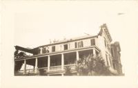
Photograph of First Scots Presbyterian Church [57 Meeting Street] after the tornadoes of September 29, 1938, showing the damage done to the building. The Nathaniel Russell House can be seen in the background. Cars are parked on the street in front of the church.
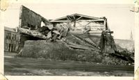
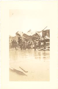
Photograph of the ruins of a building on King Street after the tornadoes of September 29, 1938. Shows the debris of a completely demolished structure and the damaged roof of the neighboring building. Based on newspaper accounts, this is probably the site of the Rectory of the Church of the Sacred Heart at King and Huger Streets. Three men stand on the sidewalk facing the debris; other men are standing on a pile of debris.
Looking east on Market Street after the tornadoes of September 29, 1938, showing the Market Sheds in ruins. A damaged car is parked along side of the debris. The Old Church of the Redeemer can be seen in the background.
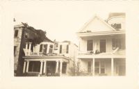
Photograph of 38 South Battery and 40 South Battery [Frederick Heinz Houses] and a portion of 42 South Battery, after the tornadoes of September 29, 1938, showing the damage done to the houses.
Photograph 19 King Street [Thomas Lamboll House] after the tornadoes of September 29, 1938, showing the damage done to the house. King Street elevation.
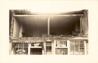
Photograph of the Sing Lee Laundry (133 King Street) after the tornadoes of September 29, 1938, showing the damage done to the building. Signs for the Robbins Bros. Circus (on Sept. 26) are posted in the windows.
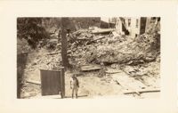
Photograph of the ruins of a building, after the September 29, 1938, tornadoes. Based on newspaper accounts, it is probably the site of 45 State Street. Infantry patrolman stands in foreground.
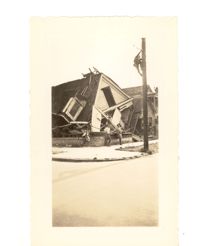
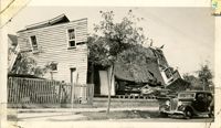
Photograph of the destruction of a house done by the tornadoes of September, 29, 1938. Based on newspaper accounts, the home was probably located in the Fiddlers' Green neighborhood near the Ashley River. Two men lean against the ruins while another man climbs a nearby telephone pole.
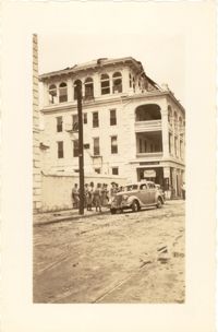
Photograph of the I.M. Pearlstine Building (203 East Bay Street), located on the southwest corner of East Bay Street and Street, after the tornado of September 29, 1938, showing the damage done to the building. Also shows 205 East Bay Street, located on the northwest corner of East Bay and Cumberland. "Bay City" heavy equipment vehicle (excavator?) parked in front of building. Pedestrian and a street worker walking on the sidewalk; repairman on the utility pole on the street corner.
Photograph of the Timrod Hotel [ca. 101 Meeting Street], after the tornadoes of September 29, 1938, showing the damage done to the building. View of the hotel looking north on Meeting Street (southeast elevation). Infantry patrolmen stand on sidewalk by a car. Signage for Byars Drug Store is on the south elevation. [Note: The hotel was later demolished in the 1960s.]
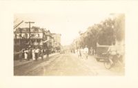
Photograph of Broad Street, looking east at the 60 block, showing the scene on the street after the tornadoes of September 29, 1938. The Daniel Ravenel House (68 Broad Street), the Confederate Home, and the People's Building can be seen at the right; the Old Exchange Building is visible in the background. Onlookers, cars, and a person riding a bicycle are on the street.
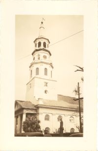
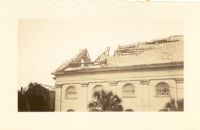
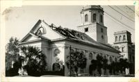
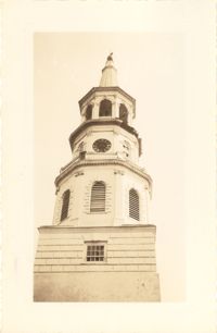
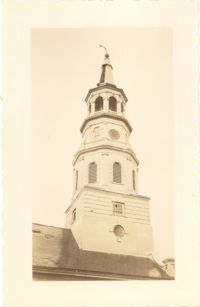
Photograph of St. Michael's Church after the first tornado of September 29, 1938, showing the damage done to the roof. Handwritten on back of photo: "Old historic St. Michael's Church, corner Broad Street and Meeting Street. Done by first tornado, Sept. 29, '38."
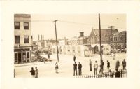
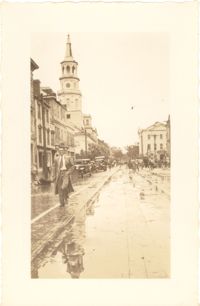
Photograph of Broad Street, looking west, showing the scene on the street after the tornadoes of September 29, 1938. South side of the 60 block of Broad Street in foreground; St. Michael's Church and the Charleston County Courthouse in the background. Onlookers and vehicles are on the street.
Photograph of the wreckage of the Calvary Baptist Church, an African-American church demolished by the tornado of September 29, 1938. Located at the corner of Sumter Street and Ashley Avenue; address may have been 387 Sumter Street. Handwritten on back of photo: "Old Negro church on Sumter Street, corner of Ashley Avenue. This was done by second tornado that hit 2 miles from the other one. Sept. 29, 1938."
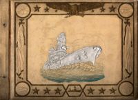
A photograph album created by William Muckenfuss for Mrs. Frances A. Robb, in the 1940s. Album contains photographs of various Charleston buildings, houses, landmarks, sites, events, battleships, and people as well as other Lowcountry places. Mrs. Robb lived on Wentworth Street and several photographs are of her home and neighborhood.