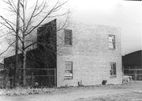
Side view of commercial building with 6 bays (garage?) on site affected by the construction of Interstate 26 (I-26). Address: 739 Meeting Street. Surveyor notations on back of photo: "Dkt.: 10.503. Property owner: Alton M. Silver. Tract: 58. Station: 5908+15 Lt. Date: Feb. 20, 1963. In R/W - Bought." [See collection description for explanation of surveyor notations.]
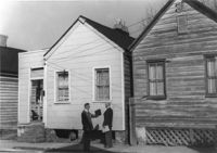
House-like structure on site affected by the construction of Interstate 26 (I-26). Address: 739 Meeting Street. Surveyor notations on back of photo: "Dkt.: 10.503. Property owner: George E. Williams. Tract: 60. Station: 5909+30 Rt. Date: Feb. 20, 1963. In R/W - Bought." [See collection description for explanation of surveyor notations.]
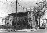
Street corner and houses on site affected by the construction of the Crosstown. Address: 100 Sheppard Street. Surveyor notations on back of photo: "Dkt.: 10.518. Property owner: M.J. Christine Butt, Est. Tract: 19. Station: 29+40 Lt. Sheppard Street. Date: Mar. 6, 1963. In R/W - Bought. [See collection description for explanation of surveyor notations.]
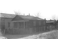
House-like structure (rear view) and neighboring structures on site affected by the construction of Interstate 26 (I-26). Address: 739 Meeting Street. Surveyor notations on back of photo: "Dkt.: 10.503. Property owner: George E. Williams. Tract: 60. Station: 5909+30 Rt. Date: Feb. 20, 1963. In R/W - Bought." [See collection description for explanation of surveyor notations.]
House-like structure in dilapidated condition (side view) on site affected by the construction of Interstate 26 (I-26). Dirt lot in foreground. Address: 739 Meeting Street. Surveyor notations on back of photo: "Dkt.: 10.503. Property owner: Eula Chitwood. Tract: 61. Station: 5909+30 Rt. Date: Feb. 20, 1963. In R/W - Bought." [See collection description for explanation of surveyor notations.]
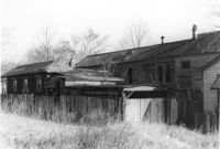
Houses (freedman's cottages) on site affected by the construction of Interstate 26 (I-26). Address: 12-14 Riker Street. Surveyor notations on back of photo: "Dkt.: 10.503. Property owner: Jesse Williams. Tract: 62. Station: 5910+40 Lt. Date: Feb. 20, 1963. In R/W - Bought." [See collection description for explanation of surveyor notations.]
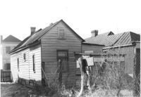
Houses (freedman's cottages) (rear view) on site affected by the construction of Interstate 26 (I-26). Address: 12-14 Riker Street. Surveyor notations on back of photo: "Dkt.: 10.503. Property owner: Jesse Williams. Tract: 62. Station: 5910+40 Lt. Date: Feb. 20, 1963. In R/W - Bought." [See collection description for explanation of surveyor notations.]
House (freedman's cottage) (rear view) on site affected by the construction of Interstate 26 (I-26). Address: 16 Riker Street. Surveyor notations on back of photo: "Dkt.: 10.503. Property owner: Mary M. Polite, Est. Tract: 63. Station: 5910+50 Lt. Date: Feb. 20, 1963. In R/W - Bought." [See collection description for explanation of surveyor notations.]
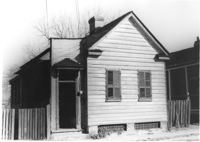
House (freedman's cottage) on site affected by the construction of Interstate 26 (I-26). Address: 16 Riker Street. Surveyor notations on back of photo: "Dkt.: 10.503. Property owner: Mary M. Polite, Est. Tract: 63. Station: 5910+50 Lt. Date: Feb. 20, 1963. In R/W - Bought." [See collection description for explanation of surveyor notations.]
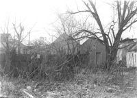
Lot on site affected by the construction of Interstate 26 (I-26). Address: behind 12-14 Riker Street, which can be seen in the background. Surveyor notations on back of photo: "Dkt.: 10.503. Property owner: Katie C. Solomons. Tract: 62-A. Station: 5910+40 Lt. Date: Feb. 20, 1963. Buy fence & slat shed." [See collection description for explanation of surveyor notations.]