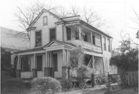
House on site affected by the construction of the Crosstown. Address: 117 Sheppard Street. Surveyor notations on back of photo: "Dkt.: 10.524. Property owner: Julia Sharpe, et al., Est. Tract: 140. Station: 17+85 Rt. N.B. lane. Date: Dec. 2, 1964. Condemned." [See collection description for explanation of surveyor notations.]
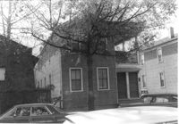
House on Sheppard Street on site affected by the widening of U.S. Route 17. Address 131 Sheppard Street. Surveyor notations on back of photo: "Dkt.: 10.524. Property owner: William Delestine, et al. Tract: 127. Station: 90+20 CL. Date: Dec. 2, 1964. In R/W - Bought." [See collection description for explanation of surveyor notations.]
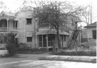
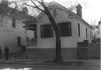
House on site affected by the construction of the Crosstown. Address: 127 Sheppard Street. Surveyor notations on back of photo: "Dkt.: 10.524. Property owner: Essie W. Jenkins. Tract: 129. Station: 91+50 Rt. Date: Dec. 2, 1964. In R/W - Bought." [See collection description for explanation of surveyor notations.]
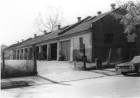
City Garage, on site affected by the construction of the Crosstown. Address: 134 Line Street. Surveyor notations on back of photo: "Dkt.: 10.524. Property owner: City of Charleston. Tract: 128. Station: 90+50 CL Rt. Date: Dec. 2, 1964. Partially in R/W." [See collection description for explanation of surveyor notations.]
City Garage, on site affected by the construction of the Crosstown. Address: 134 Line Street. Surveyor notations on back of photo: "Dkt.: 10.524. Property owner: City of Charleston. Tract: 128. Station: 90+50 CL Rt. Date: Dec. 2, 1964. Partially in R/W." [See collection description for explanation of surveyor notations.]
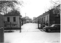
Looking down driveway between City Garage and building with gas pump, on site affected by the construction of the Crosstown. Address: 134 Line Street. Surveyor notations on back of photo: "Dkt.: 10.524. Property owner: City of Charleston. Tract: 128. Station: 91+00 CL Rt. Date: Dec. 2, 1964. Panoramic view." [See collection description for explanation of surveyor notations.]
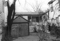
Storage shed or garage and backyard in rear of house on site affected by the construction of the Crosstown. Address: 160½ Line Street [160 Line Street]. Surveyor notations on back of photo: "Dkt.: 10.524. Property owner: John Meyer, Est. Tract: 101. Station: 83+65 Lt. Date: Dec. 1, 1964. In R/W - Bought." [See collection description for explanation of surveyor notations.]
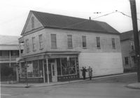
House (corner view) on site affected by the construction of the Crosstown. Address: 205 Spring Street. First story was a store front; has signage indicating its move to 216 Spring Street. View of street corner (corner of Spring Street and Courtenay Street). Surveyor notations on back of photo: "Dkt.: 10.524. Property owner: Katie Anna Meier, Est. Tract: 168. Station: 21+20 Rt. Spring Street. Date: Dec. 2, 1964." [See collection description for explanation of surveyor notations.]
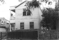
House on site affected by the construction of the Crosstown. Address: 71 Kracke Street. Surveyor notations on back of photo: "Dkt.: 10.524. Property owner: William Henry Godfrey. Tract: 66. Station: 76+10 Lt. Date: Oct. 14, 1964. Portion in R/W to be removed." [See collection description for explanation of surveyor notations.]
House on site affected by the construction of the Crosstown. Address: 287 Coming Street. Surveyor notations on back of photo: "Dkt.: 10.524. Property owner: John T. Bowden. Tract: 152. Station: 21+50 Lt. S.B. lane. Date: Dec. 2, 1964. In R/W - Bought." [See collection description for explanation of surveyor notations.]