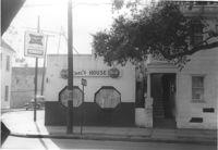
Carl's House on site affected by the construction of the Crosstown. Address: 493 Rutledge Avenue. View of street corner. Neighboring house in photo. Surveyor notations on back of photo: "Dkt.: 10.524. Property owner: Elise C. Goldberg, et al. Tract: 105. Station: 84+40 Rt. Date: Dec. 1, 1964. In R/W - Bought." [See collection description for explanation of surveyor notations.]
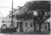
House and neighboring houses on site affected by the construction of the Crosstown. Address: 495 Rutledge Avenue and 497 Rutledge Avenue. Surveyor notations on back of photo: "Dkt.: 10.524. Property owner: Elise C. Goldberg, et al. Tract: 105. Station: 84+15 Rt. Date: Dec. 1, 1964. In R/W - Bought." [See collection description for explanation of surveyor notations.]
Dwellings--South Carolina--Charleston, Right of way--South Carolina--Charleston County, Highway planning--South Carolina--Charleston County, Commercial buildings--South Carolina--Charleston County, Vernacular architecture--South Carolina--Charleston County, Lost architecture--South Carolina--Charleston County, Bars (Drinking establishments)--South Carolina--Charleston County✖[remove]2