Plat of 19 acres in St. Andrew’s Parish. A corn field is noted as is a public road along with the neighboring property owners. Little other detail. Names associated with this plat are James C. Perry, Cook, Sault, Benjamin, F.R.N. [?] Smith, Dinzhals [?], S. Charles, and Cattell.
Plat of 288 acres of land situated on Wadmalaw Island. Names associated with this plat are William Weston, Jonathan Runnel, James Clarks, Benjamin Allston [?], and Henry Treads. Notable geographic locations include Wadmalaw River, Wadmalaw Island, Bain Bluff, and Charleston District.
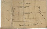
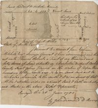
Plat of 640 acres of land belonging to Thomas Roberts situated in Berkeley County on the Cooper River bounding to the North and NE on land lad out to Nicholas Aremile to the south and SW on lands of Robert Miles and all other sides on vacant land. Names associated with this plat are John Berry, Ephraim Mitchell, Thomas Roberts, Nicholas Roberts, Nicholas Aremile, Robert Miles, William Gilbert, Barfield Homan and John Diamond. Notable geographic locations include the St. John's Parish, Cooper River, Berkeley County and Charleston District.
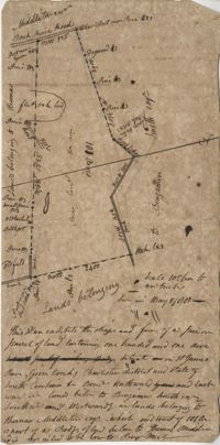
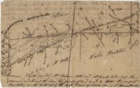
Plan of 101 acres in St. James Parish, Goose Creek belonging to Abram Jones. Details include roads, ports, banks, trees and a field. Names associated with this plat are Abram Jones, Thomas Middleton, and Major Benjamin Smith. Notable geographic locations include Goose Creek, Charleston District, and Black River Road.
Two parcels of land (A & B) on the south side of the south branch of the Santee River in St. James Parish, Charleston District. Names associated with this plat include Rebecca Motte and Jonah Collin. Notable geographic locations include Washo Plantation, St. James Parish, Santee and Charleston District.