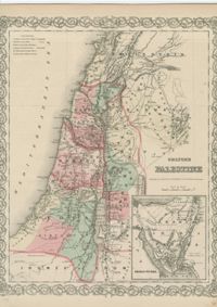
Hand-colored engraved map of Palestine. From Colton’s General atlas : containing one hundred and eighty steel plate maps and plans, on one hundred and nineteen imperial folio sheets / drawn by G. Woolworth Colton ; letter-press descriptions, geographical, statistical, and historical, by Richard Swainson Fisher, published New York: G.W. & C.B. Colton.
Limit your search
William A. Rosenthall Judaica Collection - Prints and Photographs✖[remove]1