Lot on site affected by the construction of the Crosstown. Address: 1 Lee Street. Surveyor notations on back of photo: "Dkt.: 10.518. Property owner: Ada Hamilton. Tract: 67. Station: 52+05 Lt. N.B. lane Route 17. Date: Mar. 7, 1963." [See collection description for explanation of surveyor notations.]
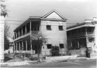
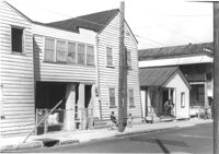
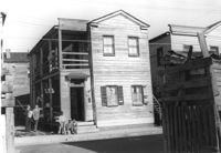
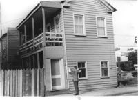
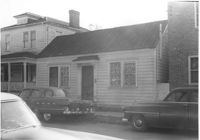
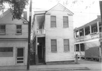
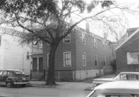
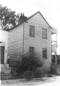
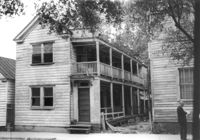
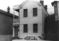
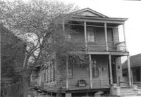
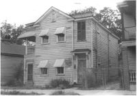
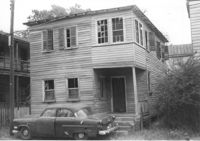
Structure on site affected by the construction of the Crosstown. Address: 122 Sheppard Street. Surveyor notations on back of photo: "Dkt.: 10.524. Property owner: Archie B. Hollins. Tract: 136. Station: 17+40 Lt. S.B. lane. Date: Dec. 2, 1964. Outside R/W." [See collection description for explanation of surveyor notations.]
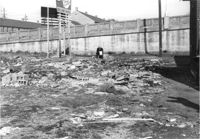
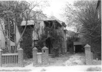
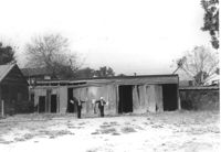
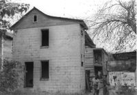
Lot with collapsed building, on site affected by the construction of the Crosstown. Address: 3 Rosemont Street. Surveyor notations on back of photo: "Dkt.: 10.524. Property owner: Christopher Ward. Tract: 54. Station: 71+70 Rt. Date: Oct. 14, 1964." [See collection description for explanation of surveyor notations.]
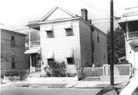
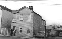
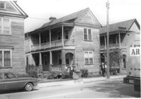
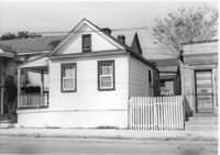
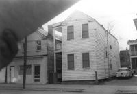
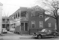
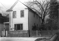
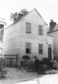
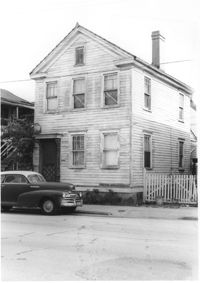
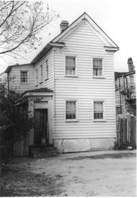
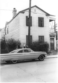
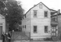
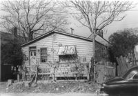
House on site affected by the construction of the Crosstown. Address: 94 Sheppard Street. Surveyor notations on back of photo: "Dkt.: 10.518. Property owner: Alice Davis. Tract: 17. Station: 30+55 Lt. Sheppard Street. Date: Mar. 6, 1963. Proximity. [See collection description for explanation of surveyor notations.]
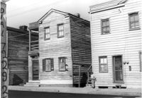
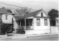
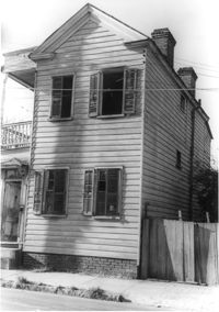
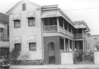
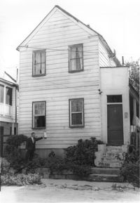
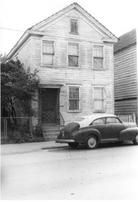
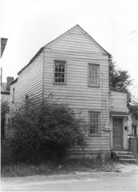
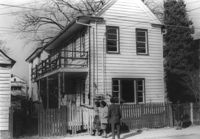
House on site affected by the construction of the Crosstown. Address: 96 Sheppard Street. Surveyor notations on back of photo: "Dkt.: 10.518. Property owner: Celia McFadden. Tract: 18. Station: 30+10 Lt. Sheppard Street. Date: Mar. 6, 1963. In R/W - Bought. [See collection description for explanation of surveyor notations.]
House on site affected by the construction of the Crosstown. Address: 96 Sheppard Street. Surveyor notations on back of photo: "Dkt.: 10.518. Property owner: Celia McFadden. Tract: 18. Station: 30+10 Lt. Sheppard Street. Date: Mar. 6, 1963. In R/W - Bought. [See collection description for explanation of surveyor notations.]
House on site affected by the construction of the Crosstown. Address: 96 Sheppard Street. Surveyor notations on back of photo: "Dkt.: 10.518. Property owner: Celia McFadden. Tract: 18. Station: 30+10 Lt. Sheppard Street. Date: Mar. 6, 1963. In R/W - Bought. [See collection description for explanation of surveyor notations.]
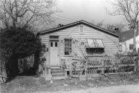
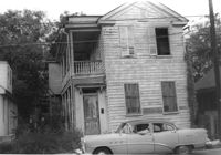
House on site affected by the construction of the Crosstown. 74 Cooper Street. Surveyor notations on back of photo: "Dkt.: 10.518. Property owner: Victoria Jenkins, Est. Tract: 21. Station: 40+30 Rt. N.B. lane Route 17. Date: Mar. 6, 1963." [See collection description for explanation of surveyor notations.]
House on site affected by the construction of the Crosstown. Address: 74 Cooper Street. Surveyor notations on back of photo: "Dkt.: 10.518. Property owner: Victoria Jenkins, Est. Tract: 21. Station: 40+30 Rt. N.B. lane Route 17. Date: Mar. 6, 1963." [See collection description for explanation of surveyor notations.]
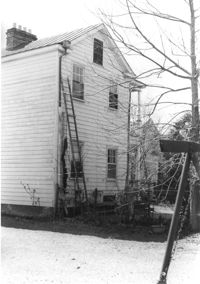
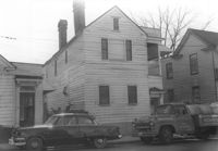
House (rear view) on site affected by the construction of the Crosstown. Address: 74 Cooper Street. Surveyor notations on back of photo: "Dkt.: 10.518. Property owner: Victoria Jenkins, Est. Tract: 21. Station: 40+30 Rt. N.B. lane Route 17. Date: Mar. 6, 1963." [See collection description for explanation of surveyor notations.]
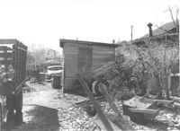
"Junk lot" behind houses on site affected by the construction of the Crosstown. Address: 171 Nassau Street. Surveyor notations on back of photo: "Dkt.: 10.518. Property owner: Samuel J. Lloyd. Tract: 24. Station: 40+70 CL N.B. lane Route 17. Date: Mar. 6, 1963. In R/W - Bought. [See collection description for explanation of surveyor notations.]
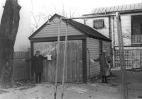
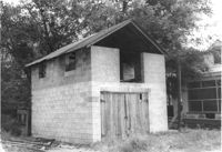
Storage shed on site affected by the construction of the Crosstown. Address182 Nassau Street. Surveyor notations on back of photo: "Dkt.: 10.518. Property owner: Euphrasia E. Lewis. Tract: 35. Station: 42+40 CL S.B. lane Route 17. Date: Mar. 6, 1963. In R/W - Bought. [See collection description for explanation of surveyor notations.]
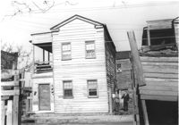
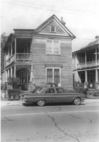
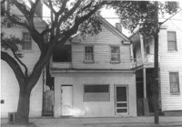
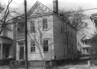
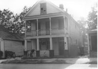
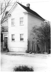
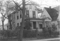
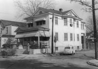
House on site affected by the construction of the Crosstown. Address: 88 Hanover Street. Surveyor notations on back of photo: "Dkt.: 10.518. Property owner: Jerusalem Baptist Church. Tract: 43. Station: 43+90 CL line 9 north of Cooper Street. Date: Mar. 6, 1963." [See collection description for explanation of surveyor notations.]
House on site affected by the construction of the Crosstown. Address: 88 Hanover Street. Surveyor notations on back of photo: "Dkt.: 10.518. Property owner: Jerusalem Baptist Church. Tract: 43. Station: 43+90 CL line 9 north of Cooper Street. Date: Mar. 6, 1963." [See collection description for explanation of surveyor notations.]
House on site affected by the construction of the Crosstown. Address: 90 Hanover Street. Surveyor notations on back of photo: "Dkt.: 10.518. Property owner: Jerusalem Baptist Church. Tract: 44. Station: 44+20 CL line 9 north of Cooper Street. Date: Mar. 6, 1963." [See collection description for explanation of surveyor notations.]
House on site affected by the construction of the Crosstown. Address: 90 Hanover Street. Surveyor notations on back of photo: "Dkt.: 10.518. Property owner: Jerusalem Baptist Church. Tract: 44. Station: 44+20 CL line 9 north of Cooper Street. Date: Mar. 6, 1963." [See collection description for explanation of surveyor notations.]
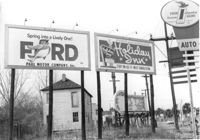
Lot with billboards on site affected by the construction of the Crosstown. Address: 53 Lee Street. Surveyor notations on back of photo: "Dkt.: 10.518. Property owner: Turner Advertising Co. Tract: 50. Station: 46+00 Rt. N.B. lane Route 17. Date: Mar. 6, 1963. In R/W." [See collection description for explanation of surveyor notations.]
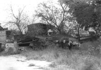
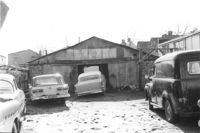
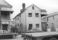
Structure (garage?) and cars in lot on site affected by the construction of the Crosstown. Address: 51 Aiken Street. Surveyor notations on back of photo: "Dkt.: 10.518. Property owner: Julia M. Pritchard. Tract: 52. Station: 46+50 Rt. N.B. lane Route 17. Date: Mar. 6, 1963. In R/W - Bought." [See collection description for explanation of surveyor notations.]
Lot on site affected by the construction of the Crosstown. Address: 51 Aiken Street. Surveyor notations on back of photo: "Dkt.: 10.518. Property owner: Julia M. Pritchard. Tract: 52. Station: 46+50 Rt. N.B. lane Route 17. Date: Mar. 7, 1963. In R/W - Bought." [See collection description for explanation of surveyor notations.]
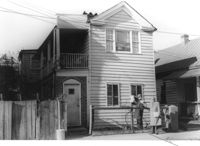
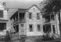
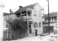
House on site affected by the construction of the Crosstown. Address: 55 Aiken Street. Surveyor notations on back of photo: "Dkt.: 10.518. Property owner: Julius Mitchell. Tract: 53. Station: 47+20 Rt. N.B. lane Route 17. Date: Mar. 7, 1963." [See collection description for explanation of surveyor notations.]
House on site affected by the construction of the Crosstown. Address: 55 Aiken Street. Surveyor notations on back of photo: "Dkt.: 10.518. Property owner: Julius Mitchell. Tract: 53. Station: 47+20 Rt. N.B. lane Route 17. Date: Mar. 7, 1963." [See collection description for explanation of surveyor notations.]
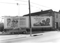
Billboards on lot, on site affected by the construction of the Crosstown. Address: 34-36 Lee Street. Surveyor notations on back of photo: "Dkt.: 10.518. Property owner: Turner Advertising. Tract: 65. Station: 51±45 Rt. & Lt. N.B. lane Route 17. Date: Mar. 7, 1963. Signs. [See collection description for explanation of surveyor notations.]
House on site affected by the construction of the Crosstown. Address: 166 Cannon Street. Surveyor notations on back of photo: "Dkt.: 10.524. Property owner: Andrew J. McGuinness, Est. Tract: 1. Station: 59+60 Lt. Date: Oct. 13, 1964. Proximity." [See collection description for explanation of surveyor notations.]
House on site affected by the construction of the Crosstown. Address: 164 Cannon Street. Surveyor notations on back of photo: "Dkt.: 10.524. Property owner: Leola G. McKelvin. Tract: 2. Station: 60+00 Lt. Date: Oct. 13, 1964. Proximity." [See collection description for explanation of surveyor notations.]
House on site affected by the construction of the Crosstown. Address: 139 Sheppard Street. Surveyor notations on back of photo: "Dkt.: 10.524. Property owner: Wilmot J. Frasier. Tract: 125. Station: 89+15 Lt. Date: Dec. 2, 1964. In R/W - Bought." [See collection description for explanation of surveyor notations.]
House on site affected by the construction of the Crosstown. Address: 139 Sheppard Street. Surveyor notations on back of photo: "Dkt.: 10.524. Property owner: Wilmot J. Frasier. Tract: 125. Station: 89+15 Lt. Date: Dec. 2, 1964. In R/W - Bought." [See collection description for explanation of surveyor notations.]
House on Sheppard Street on site affected by the construction of the Crosstown. Address: 137 Sheppard Street. Surveyor notations on back of photo: "Dkt.: 10.524. Property owner: Frank Williams. Tract: 126. Station: 89+40 Lt. Date: Dec. 2, 1964. In R/W - Bought." [See collection description for explanation of surveyor notations.]
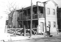
House (rear view) on site affected by the construction of the Crosstown. Address: 152-150 Line Street. Surveyor notations on back of photo: "Dkt.: 10.524. Property owner: John N. Peeksen. Tract: 117. Station: 86+70 Rt. Date: Dec. 1, 1964. In R/W." [See collection description for explanation of surveyor notations.]
House (rear view) on site affected by the construction of the Crosstown. Address: 11 Presidents Place. Surveyor notations on back of photo: "Dkt.: 10.524. Property owner: Lucille Smalls. Tract: 9. Station: 63+10 Rt. Date: Oct. 13, 1964. In R/W - Bought." [See collection description for explanation of surveyor notations.]
House on site affected by the construction of the Crosstown. Address: 162 Cannon Street. Surveyor notations on back of photo: "Dkt.: 10.524. Property owner: Willie Williams. Tract: 4. Station: 61+15 Rt. Date: Oct. 13, 1964. In R/W - Bought." [See collection description for explanation of surveyor notations.]
House on site affected by the construction of the Crosstown. Address: 162 Cannon Street. Surveyor notations on back of photo: "Dkt.: 10.524. Property owner: Willie Williams. Tract: 4. Station: 61+15 Rt. Date: Oct. 13, 1964. In R/W - Bought." [See collection description for explanation of surveyor notations.]
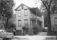
House and driveway on site affected by the construction of the Crosstown. Address: 6 Norman Street. Surveyor notations on back of photo: "Dkt.: 10.524. Property owner: Julia Williams Glover. Tract: 22. Station: 67+00 Lt. Date: Oct. 13, 1964. In R/W - Bought." [See collection description for explanation of surveyor notations.]
House on site affected by the construction of the Crosstown. Address: 10 Kennedy Street. Surveyor notations on back of photo: "Dkt.: 10.524. Property owner: Lucille Beall. Tract: 93. Station: 81+50 CL. Date: Dec. 1, 1964. In R/W - Bought." [See collection description for explanation of surveyor notations.]
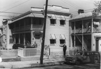
House on site affected by the construction of the Crosstown. Address: 499 Rutledge Avenue. Surveyor notations on back of photo: "Dkt.: 10.524. Property owner: Clinton I. Young. Tract: 107. Station: 84+60 Rt. Date: Dec. 1, 1964. In R/W - Bought." [See collection description for explanation of surveyor notations.]
House on site affected by the construction of the Crosstown. Address: 499 Rutledge Avenue. Surveyor notations on back of photo: "Dkt.: 10.524. Property owner: Clinton I. Young. Tract: 107. Station: 84+60 Rt. Date: Dec. 1, 1964. In R/W - Bought." [See collection description for explanation of surveyor notations.]
House on site affected by the construction of the Crosstown. Address: 497 Rutledge Avenue. Surveyor notations on back of photo: "Dkt.: 10.524. Property owner: Rebecca S. Brown. Tract: 106. Station: 84+50 Rt. Date: Dec. 1, 1964. In R/W - Bought." [See collection description for explanation of surveyor notations.]
House on site affected by the construction of the Crosstown. Address: 497 Rutledge Avenue. Surveyor notations on back of photo: "Dkt.: 10.524. Property owner: Rebecca S. Brown. Tract: 106. Station: 84+50 Rt. Date: Dec. 1, 1964. In R/W - Bought." [See collection description for explanation of surveyor notations.]
House on site affected by the construction of the Crosstown. Address: 9 Todd Street. Surveyor notations on back of photo: "Dkt.: 10.524. Property owner: Daniel Frasier. Tract: 121. Station: 87+90 Lt. Date: Dec. 2, 1964. Partially in R/W." [See collection description for explanation of surveyor notations.]
House on site affected by the construction of the Crosstown. Address: 7 Todd Street. Surveyor notations on back of photo: "Dkt.: 10.524. Property owner: Daniel Frasier. Tract: 120. Station: 87+90 Lt. Date: Dec. 2, 1964. In R/W - Bought." [See collection description for explanation of surveyor notations.]
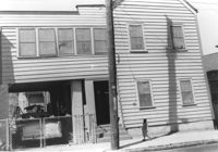
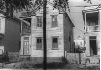
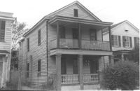
House on site affected by the construction of the Crosstown. Address: 108 Sheppard Street. Surveyor notations on back of photo: "Dkt.: 10.524. Property owner: Abe Kirshtein. Tract: 148. Station: 20+20 Rt. S.B. lane. Date: Dec. 2, 1964. In R/W - Bought." [See collection description for explanation of surveyor notations.]
House on site affected by the construction of the Crosstown. Address: 268 Ashley Avenue. Surveyor notations on back of photo: "Dkt.: 10.524. Property owner: J. Arthur Brown. Tract: 78. Station: 79+60 Rt. Date: Oct. 14, 1964. Proximity." [See collection description for explanation of surveyor notations.]
House on site affected by the construction of the Crosstown. Address: 6 Norman Street. Surveyor notations on back of photo: "Dkt.: 10.524. Property owner: Julia Williams Glover. Tract: 22. Station: 67+00 Lt. Date: Oct. 13, 1964. In R/W - Bought." [See collection description for explanation of surveyor notations.]
House on site affected by the construction of the Crosstown. Address: 213 Spring Street. Surveyor notations on back of photo: "Dkt.: 10.524. Property owner: Loretta Jackson. Tract: 164. Station: 19+30 Rt. Spring Street. Date: Dec. 2, 1964. Condemned." [See collection description for explanation of surveyor notations.]
House on site affected by the construction of the Crosstown. Address: 213 Spring Street. Surveyor notations on back of photo: "Dkt.: 10.524. Property owner: Loretta Jackson. Tract: 164. Station: 19+30 Rt. Spring Street. Date: Dec. 2, 1964. Condemned." [See collection description for explanation of surveyor notations.]
Lot with billboards for 1965 Corvair (Fort Sumter Chevrolet Co.) and Falstaff (beer), on site affected by the construction of the Crosstown. Address: 223 Spring Street. Surveyor notations on back of photo: "Dkt.: 10.524. Property owner: Turner Advertising Co. Tract: 159. Station: 16±80 Rt. Date: Dec. 2, 1964." [See collection description for explanation of surveyor notations.]
House on site affected by the construction of the Crosstown. Address: 116 Sheppard Street. Surveyor notations on back of photo: "Dkt.: 10.524. Property owner: Margaret Oree. Tract: 144. Station: 18+90 CL S.B. lane. Date: Dec. 2, 1964. Condemned." [See collection description for explanation of surveyor notations.]
House on site affected by the construction of the Crosstown. Address: 116 Sheppard Street. Surveyor notations on back of photo: "Dkt.: 10.524. Property owner: Margaret Oree. Tract: 144. Station: 18+90 CL S.B. lane. Date: Dec. 2, 1964. Condemned." [See collection description for explanation of surveyor notations.]
House on site affected by the construction of the Crosstown. Address: 501 Rutledge Avenue. Surveyor notations on back of photo: "Dkt.: 10.524. Property owner: William DeLesline, et al. Tract: 108. Station: 84+85 Lt. Date: Dec. 1, 1964. In R/W - Bought." [See collection description for explanation of surveyor notations.]
House on site affected by the construction of the Crosstown. Address: 501 Rutledge Avenue. Surveyor notations on back of photo: "Dkt.: 10.524. Property owner: William DeLesline, et al. Tract: 108. Station: 84+85 Lt. Date: Dec. 1, 1964. In R/W - Bought." [See collection description for explanation of surveyor notations.]
House on site affected by the construction of the Crosstown. Address: 160 Line Street. Surveyor notations on back of photo: "Dkt.: 10.524. Property owner: John Meyer, Est. Tract: 101. Station: 83+30 CL. Date: Dec. 1, 1964. In R/W - Bought." [See collection description for explanation of surveyor notations.]
House on site affected by the construction of the Crosstown. Address: 160 Line Street. Surveyor notations on back of photo: "Dkt.: 10.524. Property owner: John Meyer, Est. Tract: 101. Station: 83+30 CL. Date: Dec. 1, 1964. In R/W - Bought." [See collection description for explanation of surveyor notations.]
House on site affected by the construction of the Crosstown. Address: 162 Line Street. Surveyor notations on back of photo: "Dkt.: 10.524. Property owner: James Washington. Tract: 100. Station: 82+85 Lt. Date: Dec. 1, 1964. In R/W - Bought." [See collection description for explanation of surveyor notations.]
Storage shed or garage on site affected by the construction of the Crosstown. Address: 160 Line Street. Surveyor notations on back of photo: "Dkt.: 10.524. Property owner: John Meyer, Est. Tract: 101. Station: 83+25 Lt. Date: Dec. 1, 1964. In R/W - Bought." [See collection description for explanation of surveyor notations.]
House on site affected by the construction of the Crosstown. Address: 147 President Street. Surveyor notations on back of photo: "Dkt.: 10.524. Property owner: Frank Chinners. Tract: 31. Station: 67+60 Rt. Date: Oct. 13, 1964. Partially In R/W - Bought." [See collection description for explanation of surveyor notations.]
House on site affected by the construction of the Crosstown. Address: 9 Presidents Place. Surveyor notations on back of photo: "Dkt.: 10.524. Property owner: Mary Robinson, Est. Tract: 8. Station: 63+40 Rt. Date: Oct. 13, 1964. In R/W - Bought." [See collection description for explanation of surveyor notations.]
House on site affected by the construction of the Crosstown. Address: 9 Presidents Place. Surveyor notations on back of photo: "Dkt.: 10.524. Property owner: Mary Robinson, Est. Tract: 8. Station: 63+40 Rt. Date: Oct. 13, 1964. In R/W - Bought." [See collection description for explanation of surveyor notations.]
House on site affected by the construction of the Crosstown. Address: 11 Presidents Place. Surveyor notations on back of photo: "Dkt.: 10.524. Property owner: Lucille Smalls. Tract: 9. Station: 63+10 Rt. Date: Oct. 13, 1964. In R/W - Bought." [See collection description for explanation of surveyor notations.]
Structure and lot on site affected by the construction of the Crosstown. Address: 160 Cannon Street. Surveyor notations on back of photo: "Dkt.: 10.524. Property owner: Mabel M. Cecil McIherney. Tract: 7. Station: 62+75 CL Lt. Date: Oct. 13, 1964. Portion In R/W - Bought." [See collection description for explanation of surveyor notations.]
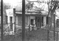
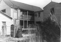
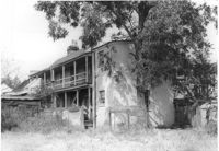
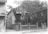
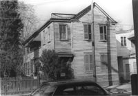
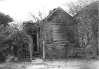
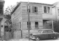
House (freedman's cottage) on site affected by the construction of the Crosstown. Address: 3 Rosemont Street. Surveyor notations on back of photo: "Dkt.: 10.524. Property owner: Christopher Ward. Tract: 54. Station: 71+70 Rt. Date: Oct. 14, 1964." [See collection description for explanation of surveyor notations.]
House on site affected by the construction of the Crosstown. Address: 159 President Street. Surveyor notations on back of photo: "Dkt.: 10.524. Property owner: James E. Campbell. Tract: 37. Station: 69+30 Lt. Date: Oct. 14, 1964. Partially in R/W." [See collection description for explanation of surveyor notations.]
House on site affected by the construction of the Crosstown. Address: 159 President Street. Surveyor notations on back of photo: "Dkt.: 10.524. Property owner: James E. Campbell. Tract: 37. Station: 69+30 Lt. Date: Oct. 14, 1964. Partially in R/W." [See collection description for explanation of surveyor notations.]
House on site affected by the construction of the Crosstown. Address: 155 President Street. Surveyor notations on back of photo: "Dkt.: 10.524. Property owner: Walter C. Middleton, Est. Tract: 35. Station: 68+90 CL Lt. Date: Oct. 13, 1964. In R/W - Bought." [See collection description for explanation of surveyor notations.]
House on site affected by the construction of the Crosstown. Address: 155 President Street. Surveyor notations on back of photo: "Dkt.: 10.524. Property owner: Walter C. Middleton, Est. Tract: 35. Station: 68+90 CL Lt. Date: Oct. 13, 1964. In R/W - Bought." [See collection description for explanation of surveyor notations.]
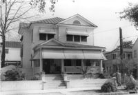
House on site affected by the construction of the Crosstown. Address: 263 Ashley Avenue. Surveyor notations on back of photo: "Dkt.: 10.524. Property owner: Zion Presbyterian Church. Tract: 79. Station: 78+50 CL Rt. Date: Oct. 14, 1964. In R/W - Bought." [See collection description for explanation of surveyor notations.]
House on site affected by the construction of the Crosstown. Address: 183 Spring Street. Surveyor notations on back of photo: "Dkt.: 10.524. Property owner: Minnie Waites, et al. Tract: 16-A. Station: 64+50 CL. Date: Oct. 13, 1964. In R/W - Bought." [See collection description for explanation of surveyor notations.]
House on site affected by the construction of the Crosstown. Address: 183 Spring Street. Surveyor notations on back of photo: "Dkt.: 10.524. Property owner: Minnie Waites, et al. Tract: 16-A. Station: 64+50 CL. Date: Oct. 13, 1964. In R/W - Bought." [See collection description for explanation of surveyor notations.]
House on site affected by the construction of the Crosstown. Address: 12 Presidents Place. Surveyor notations on back of photo: "Dkt.: 10.524. Property owner: Dewitt W. King. Tract: 16. Station: 64+00 Rt. Date: Oct. 13, 1964. In R/W - Bought." [See collection description for explanation of surveyor notations.]
House on site affected by the construction of the Crosstown. Address: 12 Presidents Place. Surveyor notations on back of photo: "Dkt.: 10.524. Property owner: Dewitt W. King. Tract: 16. Station: 64+00 Rt. Date: Oct. 13, 1964. In R/W - Bought." [See collection description for explanation of surveyor notations.]
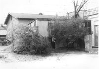
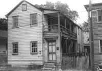
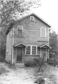
Structure (rear view) on site affected by the construction of the Crosstown. Address: 185 Spring Street. Surveyor notations on back of photo: "Dkt.: 10.524. Property owner: Star Gospel Mission. Tract: 15. Station: 24+50 Rt. (Spring Street). Date: Oct. 13, 1964. Portion in R/W to be removed." [See collection description for explanation of surveyor notations.]
House on site affected by the construction of the Crosstown. Address: 10 Presidents Place. Surveyor notations on back of photo: "Dkt.: 10.524. Property owner: Cecelia Elizabeth Cook, Est. Tract: 17. Station: 64+50 Rt. Date: Oct. 13, 1964. Partially In R/W - Bought." [See collection description for explanation of surveyor notations.]
House on site affected by the construction of the Crosstown. Address: 10 Presidents Place. Surveyor notations on back of photo: "Dkt.: 10.524. Property owner: Cecelia Elizabeth Cook, Est. Tract: 17. Station: 64+50 Rt. Date: Oct. 13, 1964. Partially In R/W - Bought." [See collection description for explanation of surveyor notations.]
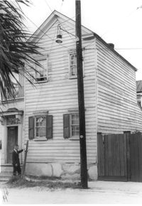
House on site affected by the construction of the Crosstown. Address: 181 Spring Street. Surveyor notations on back of photo: "Dkt.: 10.524. Property owner: Cecelia Elizabeth Cook, Est. Tract: 17. Station: 64+10 Rt. Date: Oct. 13, 1964. Partially In R/W - Bought." [See collection description for explanation of surveyor notations.]
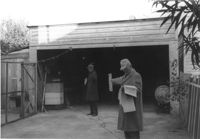
Garage on site affected by the construction of the Crosstown. Address: 508 Rutledge Avenue. Surveyor notations on back of photo: "Dkt.: 10.524. Property owner: W.C. Hayes, Est. Tract: 112. Station: 87±00. Date: Dec. 1, 1964. In R/W - Bought." [See collection description for explanation of surveyor notations.]
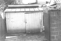
Garage on site affected by the construction of the Crosstown. Address: 510 Rutledge Avenue. Surveyor notations on back of photo: "Dkt.: 10.524. Property owner: George J. Carabates. Tract: 111. Station: 87±05 Lt. Date: Dec. 1, 1964." [See collection description for explanation of surveyor notations.]
House on site affected by the construction of the Crosstown. Address: 15 Kennedy Street. Surveyor notations on back of photo: "Dkt.: 10.524. Property owner: J. Arthur Brown. Tract: 84. Station: 80+15 CL Rt. Date: Oct. 14, 1964. In R/W - Bought." [See collection description for explanation of surveyor notations.]
House on site affected by the construction of the Crosstown. Address: 11 Kennedy Street. Surveyor notations on back of photo: "Dkt.: 10.524. Property owner: J. Arthur Brown. Tract: 87. Station: 80+65 Rt. Date: Oct. 14, 1964. In R/W - Bought." [See collection description for explanation of surveyor notations.]
House on site affected by the construction of the Crosstown. Address: 11 Kennedy Street. Surveyor notations on back of photo: "Dkt.: 10.524. Property owner: J. Arthur Brown. Tract: 87. Station: 80+65 Rt. Date: Oct. 14, 1964. In R/W - Bought." [See collection description for explanation of surveyor notations.]
House (rear view) on site affected by the construction of the Crosstown. Address: 6 Kennedy Street. Surveyor notations on back of photo: "Dkt.: 10.524. Property owner: Eugene Whitney. Tract: 89. Station: 81+80 Rt. Date: Oct. 14, 1964." [See collection description for explanation of surveyor notations.]
House on site affected by the construction of the Crosstown. Address: 162 Line Street. Surveyor notations on back of photo: "Dkt.: 10.524. Property owner: James Washington. Tract: 100. Station: 82+85 Lt. Date: Dec. 1, 1964. In R/W - Bought." [See collection description for explanation of surveyor notations.]
Rear portion of house and backyard, on site affected by the construction of the Crosstown. Address: 257 Ashley Avenue. Surveyor notations on back of photo: "Dkt.: 10.524. Property owner: Daisey DeCosta Caffry. Tract: 75. Station: 77+95 Rt. Date: Oct. 14, 1964. Proximity." [See collection description for explanation of surveyor notations.]
House on site affected by the construction of the Crosstown. Address: 114 Bogard Street. Surveyor notations on back of photo: "Dkt.: 10.524. Property owner: Francis Jenkins, et al. Tract: 64. Station: 75+70 CL Rt. Date: Oct. 14, 1964. In R/W - Bought." [See collection description for explanation of surveyor notations.]
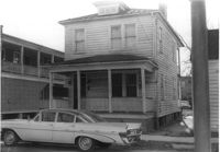
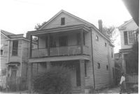
House on site affected by the construction of the Crosstown. Address: 117 Sheppard Street. Surveyor notations on back of photo: "Dkt.: 10.524. Property owner: Julia Sharpe, et al., Est. Tract: 140. Station: 17+85 Rt. N.B. lane. Date: Dec. 2, 1964. Condemned." [See collection description for explanation of surveyor notations.]
House on site affected by the construction of the Crosstown. Address: 5 Rosemont Street (rear). Surveyor notations on back of photo: "Dkt.: 10.524. Property owner: Harold I. Sherman. Tract: 53. Station: 71+70 Rt. Date: Oct. 14, 1964. In R/W - Bought." [See collection description for explanation of surveyor notations.]
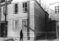
House on site affected by the construction of the Crosstown. Address: 7½ Rosemont Street [7 Rosemont Street]. Surveyor notations on back of photo: "Dkt.: 10.524. Property owner: Lauretta Izzard. Tract: 52. Station: 72+00 Rt. Date: Oct. 14, 1964. In R/W - Bought." [See collection description for explanation of surveyor notations.]
House on site affected by the construction of the Crosstown. Address: 5 Rosemont Street. Surveyor notations on back of photo: "Dkt.: 10.524. Property owner: Harold I. Sherman. Tract: 53. Station: 72+20 Rt. Date: Oct. 14, 1964." [See collection description for explanation of surveyor notations.]
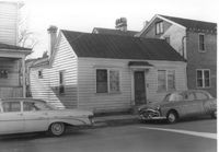
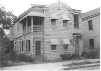
House on site affected by the construction of the Crosstown. Address: 126 Sheppard Street. Surveyor notations on back of photo: "Dkt.: 10.524. Property owner: Nathaniel M. Johnson. Tract: 134. Station: 16+70 Lt. S.B. lane. Date: Dec. 2, 1964. In R/W - Bought." [See collection description for explanation of surveyor notations.]
House on site affected by the construction of the Crosstown. Address: 122 Sheppard Street. Surveyor notations on back of photo: "Dkt.: 10.524. Property owner: Archie B. Hollins. Tract: 136. Station: 17+40 Lt. S.B. lane. Date: Dec. 2, 1964. In R/W - Bought." [See collection description for explanation of surveyor notations.]
House on site affected by the construction of the Crosstown. Address: 117 Bogard Street. Surveyor notations on back of photo: "Dkt.: 10.524. Property owner: Paul Mack. Tract: 56. Station: 74+25 Rt. Date: Oct. 14, 1964." [See collection description for explanation of surveyor notations.]
House on site affected by the construction of the Crosstown. Address: 151 President Street. Surveyor notations on back of photo: "Dkt.: 10.524. Property owner: Norman Bonneau. Tract: 33. Station: 68+35 Rt. Date: Oct. 13, 1964. In R/W - Bought." [See collection description for explanation of surveyor notations.]
House on site affected by the construction of the Crosstown. Address: 151 President Street. Surveyor notations on back of photo: "Dkt.: 10.524. Property owner: Norman Bonneau. Tract: 33. Station: 68+35 Rt. Date: Oct. 13, 1964. In R/W - Bought." [See collection description for explanation of surveyor notations.]
House on site affected by the construction of the Crosstown. Address: 153 President Street. Surveyor notations on back of photo: "Dkt.: 10.524. Property owner: Joe Aue. Tract: 34. Station: 68+60 CL. Date: Oct. 13, 1964. In R/W - Bought." [See collection description for explanation of surveyor notations.]
House on site affected by the construction of the Crosstown. Address: 153 President Street. Surveyor notations on back of photo: "Dkt.: 10.524. Property owner: Joe Aue. Tract: 34. Station: 68+60 CL. Date: Oct. 13, 1964. In R/W - Bought." [See collection description for explanation of surveyor notations.]
House on site affected by the construction of the Crosstown. Address: 10 Kennedy Street. Surveyor notations on back of photo: "Dkt.: 10.524. Property owner: Lucille Beall. Tract: 93. Station: 81+50 CL. Date: Dec. 1, 1964. In R/W - Bought." [See collection description for explanation of surveyor notations.]
House on site affected by the construction of the Crosstown. Address: 167 Line Street. Surveyor notations on back of photo: "Dkt.: 10.524. Property owner: C.F. Pequette, Est. Tract: 91. Station: 81+15 Lt. Date: Dec. 1, 1964." [See collection description for explanation of surveyor notations.]
House on site affected by the construction of the Crosstown. Address: 270 Ashley Avenue. Surveyor notations on back of photo: "Dkt.: 10.524. Property owner: J. Arthur Brown. Tract: 90. Station: 80+50 Lt. Date: Dec. 1, 1964." [See collection description for explanation of surveyor notations.]
House on site affected by the construction of the Crosstown. Address: 13 Kennedy Street. Surveyor notations on back of photo: "Dkt.: 10.524. Property owner: Frances B. Beaton, Est. Tract: 86. Station: 80+35 Rt. Date: Oct. 14, 1964. In R/W - Bought." [See collection description for explanation of surveyor notations.]
House on site affected by the construction of the Crosstown. Address: 13 Kennedy Street. Surveyor notations on back of photo: "Dkt.: 10.524. Property owner: Frances B. Beaton, Est. Tract: 86. Station: 80+35 Rt. Date: Oct. 14, 1964. In R/W - Bought." [See collection description for explanation of surveyor notations.]
House on site affected by the construction of the Crosstown. Address: 270 Ashley Avenue. View of street corner. Surveyor notations on back of photo: "Dkt.: 10.524. Property owner: J. Arthur Brown. Tract: 90. Station: 80+50 Lt. Date: Dec. 1, 1964." [See collection description for explanation of surveyor notations.]
House on site affected by the construction of the Crosstown. Address: 106 Bogard Street. Surveyor notations on back of photo: "Dkt.: 10.524. Property owner: Charity Freeman. Tract: 73. Station: 76+90 Rt. Date: Oct. 14, 1964. Proximity." [See collection description for explanation of surveyor notations.]
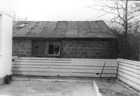
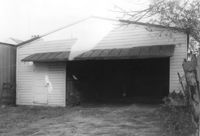
Cinder block structure (garage?) on site affected by the construction of the Crosstown. Address: 110 Bogard Street. Surveyor notations on back of photo: "Dkt.: 10.524. Property owner: Thomassina Elizabeth McCray. Tract: 72. Station: 76+60 Rt. Date: Oct. 14, 1964. In R/W - Bought." [See collection description for explanation of surveyor notations.]
Limit your search
SCDOT Photographs: Properties in the Right-of-Way✖[remove]542