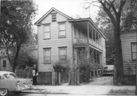
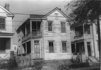
House on site affected by the construction of the Crosstown. Address: 268 Ashley Avenue. Surveyor notations on back of photo: "Dkt.: 10.524. Property owner: J. Arthur Brown. Tract: 78. Station: 79+60 Rt. Date: Oct. 14, 1964. Proximity." [See collection description for explanation of surveyor notations.]
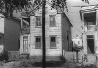
House on site affected by the construction of the Crosstown. Address: 6 Norman Street. Surveyor notations on back of photo: "Dkt.: 10.524. Property owner: Julia Williams Glover. Tract: 22. Station: 67+00 Lt. Date: Oct. 13, 1964. In R/W - Bought." [See collection description for explanation of surveyor notations.]
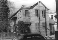
House on site affected by the construction of the Crosstown. Address: 213 Spring Street. Surveyor notations on back of photo: "Dkt.: 10.524. Property owner: Loretta Jackson. Tract: 164. Station: 19+30 Rt. Spring Street. Date: Dec. 2, 1964. Condemned." [See collection description for explanation of surveyor notations.]
House on site affected by the construction of the Crosstown. Address: 213 Spring Street. Surveyor notations on back of photo: "Dkt.: 10.524. Property owner: Loretta Jackson. Tract: 164. Station: 19+30 Rt. Spring Street. Date: Dec. 2, 1964. Condemned." [See collection description for explanation of surveyor notations.]
Lot with billboards for 1965 Corvair (Fort Sumter Chevrolet Co.) and Falstaff (beer), on site affected by the construction of the Crosstown. Address: 223 Spring Street. Surveyor notations on back of photo: "Dkt.: 10.524. Property owner: Turner Advertising Co. Tract: 159. Station: 16±80 Rt. Date: Dec. 2, 1964." [See collection description for explanation of surveyor notations.]
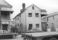
House on site affected by the construction of the Crosstown. Address: 116 Sheppard Street. Surveyor notations on back of photo: "Dkt.: 10.524. Property owner: Margaret Oree. Tract: 144. Station: 18+90 CL S.B. lane. Date: Dec. 2, 1964. Condemned." [See collection description for explanation of surveyor notations.]
House on site affected by the construction of the Crosstown. Address: 116 Sheppard Street. Surveyor notations on back of photo: "Dkt.: 10.524. Property owner: Margaret Oree. Tract: 144. Station: 18+90 CL S.B. lane. Date: Dec. 2, 1964. Condemned." [See collection description for explanation of surveyor notations.]
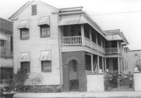
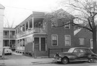
House on site affected by the construction of the Crosstown. Address: 501 Rutledge Avenue. Surveyor notations on back of photo: "Dkt.: 10.524. Property owner: William DeLesline, et al. Tract: 108. Station: 84+85 Lt. Date: Dec. 1, 1964. In R/W - Bought." [See collection description for explanation of surveyor notations.]
House on site affected by the construction of the Crosstown. Address: 501 Rutledge Avenue. Surveyor notations on back of photo: "Dkt.: 10.524. Property owner: William DeLesline, et al. Tract: 108. Station: 84+85 Lt. Date: Dec. 1, 1964. In R/W - Bought." [See collection description for explanation of surveyor notations.]
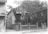
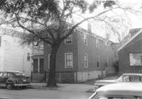
House on site affected by the construction of the Crosstown. Address: 160 Line Street. Surveyor notations on back of photo: "Dkt.: 10.524. Property owner: John Meyer, Est. Tract: 101. Station: 83+30 CL. Date: Dec. 1, 1964. In R/W - Bought." [See collection description for explanation of surveyor notations.]
Limit your search
SCDOT Photographs: Properties in the Right-of-Way✖[remove]542