Hardee's, on site affected by the construction of the Crosstown. Address: 223 Spring Street. Surveyor notations on back of photo: "Dkt.: 10.524. Property owner: Sarah Chinnis Sanders. Tract: 157. Station: 14+60 Rt. Spring Street. Date: Dec. 2, 1964." [See collection description for explanation of surveyor notations.]
Buildings and lot on site affected by the construction of the Crosstown. Address: 620 King Street. Surveyor notations on back of photo: "Dkt.: 10.518. Property owner: News & Courier. Tract: 15. Station: 8+00 Lt. Line Street (Line #2) to 9+00 Lt. Date: Mar. 6, 1963. [Zero] Fence. [See collection description for explanation of surveyor notations.]
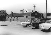
Buildings and parking lot on site affected by the construction of the Crosstown. Address: 626 King Street. Surveyor notations on back of photo: "Dkt.: 10.518. Property owner: Sands & Co. Tract: 16. Station: 9+50 Lt. Line Street (Line #2). Date: Mar. 6, 1963." [See collection description for explanation of surveyor notations.]
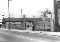
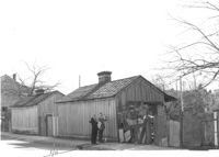
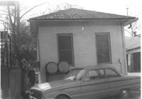
Sheds or garages on site affected by the construction of the Crosstown. Address: corner of Lanier Court and Hanover Street. Surveyor notations on back of photo: "Dkt.: 10.518. Property owner: Bessie Rosen. Tract: 41. Station: 44+40 Rt. N.B. lane Route 17. Date: Mar. 6, 1963." [See collection description for explanation of surveyor notations.]
Side view of corner grocery store on site affected by the construction of the Crosstown. Address: 121 America Street. Surveyor notations on back of photo: "Dkt.: 10.518. Property owner: Vallie Talbert. Tract: 58. Station: 49+50 Lt. N.B. lane Route 17. Date: Mar. 7, 1963." [See collection description for explanation of surveyor notations.]
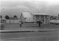
Kentucky Fried Chicken, on site affected by the construction of the Crosstown. Address: 223 Spring Street. Surveyor notations on back of photo: "Dkt.: 10.524. Property owner: Arco Investment Co. Tract: 160 and 161. Station: 17±50 Rt. Spring Street. Date: Dec. 2, 1964." [See collection description for explanation of surveyor notations.]
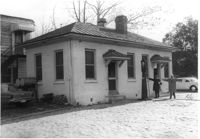
Building with gas pump (side view) on site affected by the construction of the Crosstown. Address: 134 Line Street. Surveyor notations on back of photo: "Dkt.: 10.524. Property owner: City of Charleston. Tract: 128. Station: 91+15 Rt. Date: Dec. 2, 1964. Partially in R/W." [See collection description for explanation of surveyor notations.]
Building with gas pump on site affected by the construction of the Crosstown. Address: 134 Line Street. Surveyor notations on back of photo: "Dkt.: 10.524. Property owner: City of Charleston. Tract: 128. Station: 91+15 Rt. Date: Dec. 2, 1964. Partially in R/W." [See collection description for explanation of surveyor notations.]
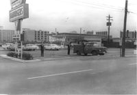
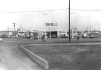
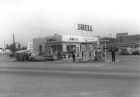
Shell gas station, on site affected by the construction of the Crosstown. Address: 233 Spring Street. View of street corner. Surveyor notations on back of photo: "Dkt.: 10.524. Property owner: Shell Oil Co. Tract: 155. Station: 9+00 Rt. Spring Street. Date: Dec. 2, 1965. Panoramic view." [See collection description for explanation of surveyor notations.]
Shell gas station, on site affected by the construction of the Crosstown. Address: 233 Spring Street. Surveyor notations on back of photo: "Dkt.: 10.524. Property owner: Shell Oil Co. Tract: 155. Station: 9+20 Rt. Spring Street. Date: Dec. 2, 1965." [See collection description for explanation of surveyor notations.]
Limit your search
SCDOT Photographs: Properties in the Right-of-Way✖[remove]43