House (freedman's cottage) on site affected by the construction of the Crosstown. Address: 3 Rosemont Street. Surveyor notations on back of photo: "Dkt.: 10.524. Property owner: Christopher Ward. Tract: 54. Station: 71+70 Rt. Date: Oct. 14, 1964." [See collection description for explanation of surveyor notations.]
House (freedman's cottage) on site affected by the construction of the Crosstown. Address: 9 Kennedy Street. Surveyor notations on back of photo: "Dkt.: 10.524. Property owner: Emmaline L. Purvis, Est. Tract: 88. Station: 80+92 Rt. Date: Oct. 14, 1964. Proximity." [See collection description for explanation of surveyor notations.]
House (freedman's cottage) on site affected by the construction of the Crosstown. Address: 26 Kracke Street. Surveyor notations on back of photo: "Dkt.: 10.524. Property owner: Julia Brown. Tract: 68. Station: 77+55 Lt. Date: Oct. 14, 1964. Proximity." [See collection description for explanation of surveyor notations.]
House (freedman's cottage) on site affected by the construction of the Crosstown. Address: 115 America Street. Surveyor notations on back of photo: "Dkt.: 10.518. Property owner: Jerusalem Baptist Church. Tract: 60. Station: 49+60 Rt. N.B. lane Route 17. Date: Mar. 7, 1963." [See collection description for explanation of surveyor notations.]
House (freedman's cottage) on site affected by the construction of the Crosstown. Address: 115 America Street. Surveyor notations on back of photo: "Dkt.: 10.518. Property owner: Jerusalem Baptist Church. Tract: 60. Station: 49+60 Rt. N.B. lane Route 17. Date: Mar. 7, 1963." [See collection description for explanation of surveyor notations.]
House (freedman's cottage) (rear view) on site affected by the construction of the Crosstown. Address: 115 America Street. Surveyor notations on back of photo: "Dkt.: 10.518. Property owner: Jerusalem Baptist Church. Tract: 60. Station: 49+10 Rt. N.B. lane Route 17. Date: Mar. 7, 1963." [See collection description for explanation of surveyor notations.]
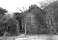
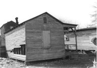
House (freedman's cottage) (rear view) on site affected by the construction of the Crosstown. Address: 2 Lee Street. Surveyor notations on back of photo: "Dkt.: 10.518. Property owner: Kate R. Rosen. Tract: 70. Station: 53+00 Rt. N.B. lane Route 17. Date: Mar. 7, 1963. In R/W - Bought." [See collection description for explanation of surveyor notations.]
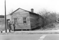
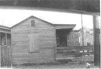
House (freedman's cottage) on site affected by the construction of the Crosstown. Address: 2 Lee Street. Surveyor notations on back of photo: "Dkt.: 10.518. Property owner: Kate R. Rosen. Tract: 71. Station: 30+00 Rt. Lee St. survey. Date: Mar. 7, 1963. In R/W - Bought." [See collection description for explanation of surveyor notations.]
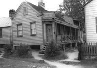
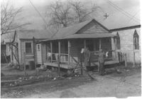
House (freedman's cottage) on site affected by the construction of the Crosstown. Address: 117 Drake Street. Surveyor notations on back of photo: "Dkt.: 10.518. Property owner: Ida Green Jenkins. Tract: 77. Station: 54+80 Rt. Date: Mar. 7, 1963. In R/W - Bought." [See collection description for explanation of surveyor notations.]
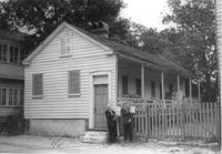
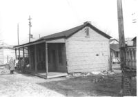
House (freedman's cottage) on site affected by the construction of the Crosstown. Address: 30 Cooper Street (30 1/3 Cooper Street). Surveyor notations on back of photo: "Dkt.: 10.518. Property owner: Edna C. Parham. Tract: 82. Station: 52+70 Rt. N.B. lane Route 17. Date: Mar. 7, 1963." [See collection description for explanation of surveyor notations.]
Limit your search
SCDOT Photographs: Properties in the Right-of-Way✖[remove]38