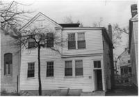
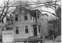
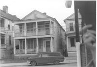
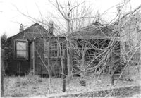
House on site affected by the construction of Interstate 26 (I-26). Address: 270 St. Philip Street. Surveyor notations on back of photo: "Dkt.: 10.517. Property owner: William H. Steedley. Tract: 114. Station: 25+40 Rt. Southbound Lane Route 17. Date: March 5, 1963. In R/W - Bought." [See collection description for explanation of surveyor notations.]
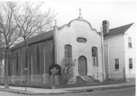
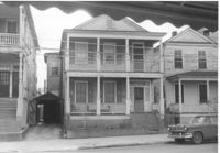
Advent Church of Charleston, on site affected by the construction of Interstate 26 (I-26). Address: 272 St. Philip Street. View of street corner. Surveyor notations on back of photo: "Dkt.: 10.517. Property owner: Advent Church of Charleston. Tract: 115. Station: 25+60 Lt. Southbound Lane Route 17. Date: March 5, 1963. In R/W - Bought." [See collection description for explanation of surveyor notations.]
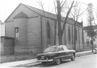
Advent Church of Charleston (corner view, rear), on site affected by the construction of Interstate 26 (I-26). Address: 272 St. Philip Street. Surveyor notations on back of photo: "Dkt.: 10.517. Property owner: Advent Church of Charleston. Tract: 115. Station: 25+60 Lt. Southbound Lane Route 17. Date: March 5, 1963. In R/W - Bought." [See collection description for explanation of surveyor notations.]
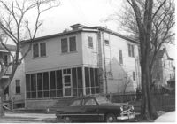
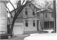
House on site affected by the construction of Interstate 26 (I-26). Address: 69 Fishburne Street. Surveyor notations on back of photo: "Dkt.: 10.517. Property owner: Ben F. Yancy, et al. Tract: 116. Station: 26+30 CL Southbound Lane Route 17. Date: March 5, 1963. In R/W - Bought." [See collection description for explanation of surveyor notations.]
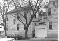
House (corner view, rear) on site affected by the construction of Interstate 26 (I-26). Address: 69 Fishburne Street. Surveyor notations on back of photo: "Dkt.: 10.517. Property owner: Ben F. Yancy, et al. Tract: 116. Station: 26+30 CL Southbound Lane Route 17. Date: March 5, 1963. In R/W - Bought." [See collection description for explanation of surveyor notations.]
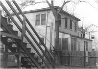
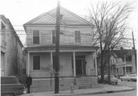
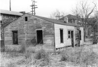
House on site affected by the construction of Interstate 26 (I-26). Address: 68 Fishburne Street. Surveyor notations on back of photo: "Dkt.: 10.517. Property owner: Annie F. Moessner. Tract: 117. Station: 26+55 Lt. Southbound Lane Route 17. Date: March 5, 1963. Proximity." [See collection description for explanation of surveyor notations.]
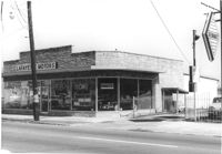
Lafayette Motors (Used Cars), on site affected by the construction of Interstate 26 (I-26). Address: 683 King Street. View of street corner (King Street and Fishburne Street. Surveyor notations on back of photo: "Dkt.: 10.517. Property owner: Hewitt Oil Co. Tract: 118. Station: 27+09 Lt. Southbound Lane Route 17. Date: March 5, 1963. Proximity." [See collection description for explanation of surveyor notations.]
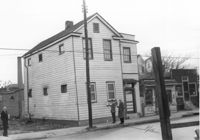
House on site affected by the construction of the Crosstown. Address: 55 Lee Street. Surveyor notations on back of photo: "Dkt.: 10.518. Property owner: Augustus G. Purvis. Tract: 49. Station: 45+55 Lt. N.B. lane Route 17. Date: Mar. 6, 1963. In R/W - Bought." [See collection description for explanation of surveyor notations.]
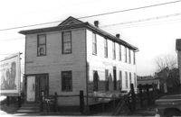
House on site affected by the construction of Interstate 26 (I-26). Address: 67 Fishburne Street. Surveyor notations on back of photo: "Dkt.: 10.517. Property owner: H.H. Rabens. Tract: 119 & 120. Station: 26+60 CL Southbound Lane Route 17. Date: March 5, 1963. In R/W - Bought." [See collection description for explanation of surveyor notations.]
House on site affected by the construction of Interstate 26 (I-26). Address: 67 Fishburne Street. Surveyor notations on back of photo: "Dkt.: 10.517. Property owner: H.H. Rabens. Tract: 119 & 120. Station: 26+60 CL Southbound Lane Route 17. Date: March 5, 1963. In R/W - Bought." [See collection description for explanation of surveyor notations.]
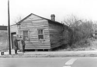
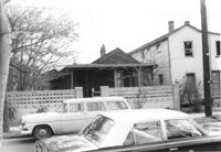
House (corner view, rear) on street corner, on site affected by the construction of Interstate 26 (I-26). Address: 681 King Street. Surveyor notations on back of photo: "Dkt.: 10.517. Property owner: H.H. Rabens. Tract: 119 & 120. Station: 27+00 Rt. Southbound Lane Route 17. Date: March 5, 1963. In R/W - Bought." [See collection description for explanation of surveyor notations.]
House on street corner, on site affected by the construction of Interstate 26 (I-26). Address: 681 King Street. View of street corner. Surveyor notations on back of photo: "Dkt.: 10.517. Property owner: H.H. Rabens. Tract: 119 & 120. Station: 27+00 Rt. Southbound Lane Route 17. Date: March 5, 1963. In R/W - Bought." [See collection description for explanation of surveyor notations.]
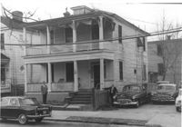
House on site affected by the construction of Interstate 26 (I-26). Address: 679 King Street. Surveyor notations on back of photo: "Dkt.: 10.517. Property owner: Meta B. Williamson. Tract: 121. Station: 27+00 Rt. Southbound Lane Route 17. Date: March 5, 1963. In R/W - Bought." [See collection description for explanation of surveyor notations.]
House on site affected by the construction of Interstate 26 (I-26). Address: 679 King Street. Surveyor notations on back of photo: "Dkt.: 10.517. Property owner: Meta B. Williamson. Tract: 121. Station: 27+00 Rt. Southbound Lane Route 17. Date: March 5, 1963. In R/W - Bought." [See collection description for explanation of surveyor notations.]
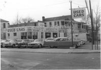
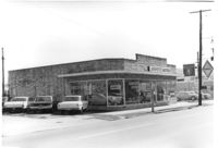
Lafayette Motors, on site affected by the construction of Interstate 26 (I-26). Address: 680 King Street. Surveyor notations on back of photo: "Dkt.: 10.517. Property owner: Raymond A. Wittschen. Tract: 122. Station: 28+35 Lt. Southbound Lane Route 17. Date: March 5, 1963. Proximity." [See collection description for explanation of surveyor notations.]
Lafayette Motors, on site affected by the construction of Interstate 26 (I-26). Address: 680 King Street. Surveyor notations on back of photo: "Dkt.: 10.517. Property owner: Raymond A. Wittschen. Tract: 122. Station: 28+35 Lt. Southbound Lane Route 17. Date: March 5, 1963. Proximity." [See collection description for explanation of surveyor notations.]
Lafayette Motors (rear view), on site affected by the construction of Interstate 26 (I-26). Address: 680 King Street. Surveyor notations on back of photo: "Dkt.: 10.517. Property owner: Raymond A. Wittschen. Tract: 122. Station: 28+35 Lt. Southbound Lane Route 17. Date: March 5, 1963. Proximity." [See collection description for explanation of surveyor notations.]
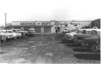
Lafayette Motors Service Dept., on site affected by the construction of Interstate 26 (I-26). Address: 680 King Street. Surveyor notations on back of photo: "Dkt.: 10.517. Property owner: Raymond A. Wittschen. Tract: 122. Station: 29±00 Lt. Southbound Lane Route 17. Date: March 5, 1963. Proximity." [See collection description for explanation of surveyor notations.]
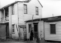
House (side view) on site affected by the construction of the Crosstown. Address: 55 Lee Street. Surveyor notations on back of photo: "Dkt.: 10.518. Property owner: Augustus G. Purvis. Tract: 49. Station: 45+55 Lt. N.B. lane Route 17. Date: Mar. 6, 1963. In R/W - Bought." [See collection description for explanation of surveyor notations.]
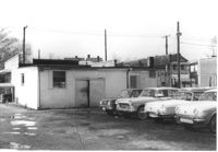
Lot with railroad tracks in foreground, behind Lafayette Motors, on site affected by the construction of Interstate 26 (I-26). Address: 680 King Street. Surveyor notations on back of photo: "Dkt.: 10.517. Property owner: Raymond A. Wittschen. Tract: 122. Station: 31± to 32± Rt. & Lt. Southbound Lane Route 17. Date: March 5, 1963." [See collection description for explanation of surveyor notations.]
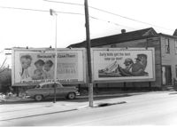
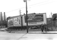
Lot with billboards on site affected by the construction of the Crosstown. Address: 53 Lee Street. Surveyor notations on back of photo: "Dkt.: 10.518. Property owner: Turner Advertising Co. Tract: 50. Station: 46+00 Rt. N.B. lane Route 17. Date: Mar. 6, 1963. In R/W." [See collection description for explanation of surveyor notations.]
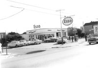
Esso (Humble) gas station on site affected by the construction of the Crosstown. Address: 53 Lee Street (corner of Lee Street and Aiken Street). Surveyor notations on back of photo: "Dkt.: 10.518. Property owner: Humble Oil Refining Co. Tract: 51. Station: 46+65 Lt. N.B. lane Route 17. Date: Mar. 6, 1963. In R/W - Bought." [See collection description for explanation of surveyor notations.]
Esso (Humble) gas station (corner view) on site affected by the construction of the Crosstown. Address: 53 Lee Street (corner of Lee Street and Aiken Street). Surveyor notations on back of photo: "Dkt.: 10.518. Property owner: Humble Oil Refining Co. Tract: 51. Station: 46+65 Lt. N.B. lane Route 17. Date: Mar. 6, 1963. In R/W - Bought." [See collection description for explanation of surveyor notations.]
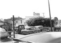
Cars in lot behind Esso (Humble) gas station on site affected by the construction of the Crosstown. Address: 53 Lee Street (corner of Lee Street and Aiken Street). Surveyor notations on back of photo: "Dkt.: 10.518. Property owner: Humble Oil Refining Co. Tract: 51. Station: 46+65 Lt. N.B. lane Route 17. Date: Mar. 6, 1963. In R/W - Bought." [See collection description for explanation of surveyor notations.]
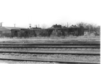
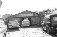
Structure (garage?) and cars in lot on site affected by the construction of the Crosstown. Address: 51 Aiken Street. Surveyor notations on back of photo: "Dkt.: 10.518. Property owner: Julia M. Pritchard. Tract: 52. Station: 46+50 Rt. N.B. lane Route 17. Date: Mar. 6, 1963. In R/W - Bought." [See collection description for explanation of surveyor notations.]
Lot on site affected by the construction of the Crosstown. Address: 51 Aiken Street. Surveyor notations on back of photo: "Dkt.: 10.518. Property owner: Julia M. Pritchard. Tract: 52. Station: 46+50 Rt. N.B. lane Route 17. Date: Mar. 7, 1963. In R/W - Bought." [See collection description for explanation of surveyor notations.]
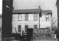
House on site affected by the construction of the Crosstown. Address: 55 Aiken Street. Surveyor notations on back of photo: "Dkt.: 10.518. Property owner: Julius Mitchell. Tract: 53. Station: 47+20 Rt. N.B. lane Route 17. Date: Mar. 7, 1963." [See collection description for explanation of surveyor notations.]
House on site affected by the construction of the Crosstown. Address: 55 Aiken Street. Surveyor notations on back of photo: "Dkt.: 10.518. Property owner: Julius Mitchell. Tract: 53. Station: 47+20 Rt. N.B. lane Route 17. Date: Mar. 7, 1963." [See collection description for explanation of surveyor notations.]
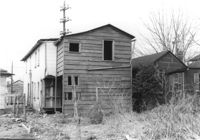
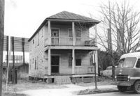
House (and neighboring buildings) on site affected by the construction of the Crosstown. Address: 60-58 Aiken Street. Public Telephone sign in foreground. Surveyor notations on back of photo: "Dkt.: 10.518. Property owner: Congaree Jenkins, Est. Tract: 54. Station: 48+00 Rt. N.B. lane Route 17. Date: Mar. 7, 1963." [See collection description for explanation of surveyor notations.]
House (rear view) and outbuilding on site affected by the construction of the Crosstown. Address: 60-58 Aiken Street. Surveyor notations on back of photo: "Dkt.: 10.518. Property owner: Congaree Jenkins, Est. Tract: 54. Station: 48+00 Rt. N.B. lane Route 17. Date: Mar. 7, 1963." [See collection description for explanation of surveyor notations.]
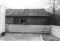
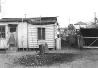
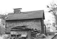
Outbuilding and lot on site affected by the construction of the Crosstown. Address: 60-58 Aiken Street. Surveyor notations on back of photo: "Dkt.: 10.518. Property owner: Congaree Jenkins, Est. Tract: 54. Station: 48+35 Rt. N.B. lane Route 17. Date: Mar. 7, 1963." [See collection description for explanation of surveyor notations.]
Sewer pump house on corner lot, on site affected by the construction of the Crosstown. Address: corner of Aiken Street and Lee Street (SE corner). View of street corner. Surveyor notations on back of photo: "Dkt.: 10.518. Property owner: City of Charleston. Tract: 56. Station: 48+00 Lt. N.B. lane Route 17. Date: Mar. 7, 1963. Sewage pumping station." [See collection description for explanation of surveyor notations.]
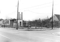
Billboards on lot, on site affected by the construction of the Crosstown. Address: corner of Lee Street and America Street (SW corner). Surveyor notations on back of photo: "Dkt.: 10.518. Property owner: Turner Advertising Co. Tract: 57. Station: 49+30 Rt. S.B. lane Route 17. Date: Mar. 7, 1963. Signs." [See collection description for explanation of surveyor notations.]
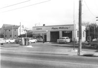
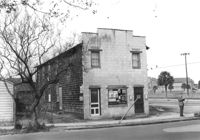
Corner grocery store on site affected by the construction of the Crosstown. Address: 121 America Street. View of street corner (America Street and Lee Street). Surveyor notations on back of photo: "Dkt.: 10.518. Property owner: Vallie Talbert. Tract: 58. Station: 49+50 Lt. N.B. lane Route 17. Date: Mar. 7, 1963." [See collection description for explanation of surveyor notations.]
Side view of corner grocery store on site affected by the construction of the Crosstown. Address: 121 America Street. Surveyor notations on back of photo: "Dkt.: 10.518. Property owner: Vallie Talbert. Tract: 58. Station: 49+50 Lt. N.B. lane Route 17. Date: Mar. 7, 1963." [See collection description for explanation of surveyor notations.]
Shed/outbuilding on site affected by the construction of the Crosstown. Address: 121 America Street. Surveyor notations on back of photo: "Dkt.: 10.518. Property owner: Vallie Talbert. Tract: 58. Station: 48+87 Lt. N.B. lane Route 17. Date: Mar. 7, 1963. All in R/W." [See collection description for explanation of surveyor notations.]
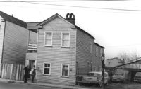
House on site affected by the construction of the Crosstown. Address: 119 America Street. Surveyor notations on back of photo: "Dkt.: 10.518. Property owner: J.A. Barrineau. Tract; 59. Station: 49+55 Rt. N.B. lane Route 17. Date: Mar. 7, 1963. In R/W - Bought." [See collection description for explanation of surveyor notations.]
House (rear view) on site affected by the construction of the Crosstown. Address: 119 America Street. Surveyor notations on back of photo: "Dkt.: 10.518. Property owner: J.A. Barrineau. Tract; 59. Station: 49+55 Rt. N.B. lane Route 17. Date: Mar. 7, 1963. In R/W - Bought." [See collection description for explanation of surveyor notations.]
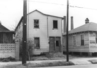
House (freedman's cottage) on site affected by the construction of the Crosstown. Address: 115 America Street. Surveyor notations on back of photo: "Dkt.: 10.518. Property owner: Jerusalem Baptist Church. Tract: 60. Station: 49+60 Rt. N.B. lane Route 17. Date: Mar. 7, 1963." [See collection description for explanation of surveyor notations.]
House (freedman's cottage) on site affected by the construction of the Crosstown. Address: 115 America Street. Surveyor notations on back of photo: "Dkt.: 10.518. Property owner: Jerusalem Baptist Church. Tract: 60. Station: 49+60 Rt. N.B. lane Route 17. Date: Mar. 7, 1963." [See collection description for explanation of surveyor notations.]
House (freedman's cottage) (rear view) on site affected by the construction of the Crosstown. Address: 115 America Street. Surveyor notations on back of photo: "Dkt.: 10.518. Property owner: Jerusalem Baptist Church. Tract: 60. Station: 49+10 Rt. N.B. lane Route 17. Date: Mar. 7, 1963." [See collection description for explanation of surveyor notations.]
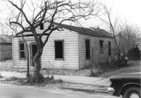
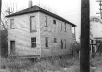
House on site affected by the construction of the Crosstown. Address: 118 America Street. Surveyor notations on back of photo: "Dkt.: 10.518. Property owner: Thelma Brown. Tract: 61. Station: 50+75 Rt. N.B. lane Route 17. Date: Mar. 7, 1963. In R/W - Bought." [See collection description for explanation of surveyor notations.]
House (rear view) on site affected by the construction of the Crosstown. Address: 118 America Street. Surveyor notations on back of photo: "Dkt.: 10.518. Property owner: Thelma Brown. Tract: 61. Station: 50+75 Rt. N.B. lane Route 17. Date: Mar. 7, 1963. In R/W - Bought." [See collection description for explanation of surveyor notations.]
House (rear view) on site affected by the construction of the Crosstown. Address: 120 America Street. Surveyor notations on back of photo: "Dkt.: 10.518. Property owner: Geraldine M. Henry. Tract: 62. Station: 50+70 Rt. N.B. lane Route 17. Date: Mar. 7, 1963. In R/W - Bought." [See collection description for explanation of surveyor notations.]
House on site affected by the construction of the Crosstown. Address: 120 America Street. Surveyor notations on back of photo: "Dkt.: 10.518. Property owner: Geraldine M. Henry. Tract: 62. Station: 50+70 Rt. N.B. lane Route 17. Date: Mar. 7, 1963. In R/W - Bought." [See collection description for explanation of surveyor notations.]
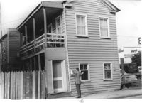
House on site affected by the construction of the Crosstown. Address: 122 America Street. Surveyor notations on back of photo: "Dkt.: 10.518. Property owner: H.B. Lasaine, et al. Tract: 63. Station: 50+70 Lt. N.B. lane Route 17. Date: Mar. 7, 1963. In R/W - Bought." [See collection description for explanation of surveyor notations.]
House (rear view) on site affected by the construction of the Crosstown. Address: 122 America Street. Surveyor notations on back of photo: "Dkt.: 10.518. Property owner: H.B. Lasaine, et al. Tract: 63. Station: 50+70 Lt. N.B. lane Route 17. Date: Mar. 7, 1963. In R/W - Bought." [See collection description for explanation of surveyor notations.]
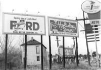
Billboards on lot, on site affected by the construction of the Crosstown. Address: 34-36 Lee Street. Surveyor notations on back of photo: "Dkt.: 10.518. Property owner: Turner Advertising. Tract: 65. Station: 51±45 Rt. & Lt. N.B. lane Route 17. Date: Mar. 7, 1963. Signs. [See collection description for explanation of surveyor notations.]
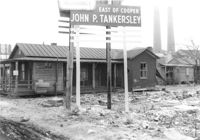
Lot on site affected by the construction of the Crosstown. Address: 32 Lee Street (south side of street). Sign for John P. Tankersley Insurance, East of Cooper. House/structure abuts lot; posted sign indicates it is closed by the Board of Health. Industrial smokestacks in background (Cigar Factory?). Surveyor notations on back of photo: "Dkt.: 10.518. Property owner: Clifton Iron. Tract: 68. Station: 52+35 Lt. N.B. lane Route 17. Date: Mar. 7, 1963. In R/W - Bought." [See collection description for explanation of surveyor notations.]
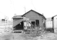
Rear of structure (see previous photo) on site affected by the construction of the Crosstown. Address: 32 Lee Street (south side of the street). Surveyor notations on back of photo: "Dkt.: 10.518. Property owner: Clifton Iron. Tract: 68. Station: 52+35 Lt. N.B. lane Route 17. Date: Mar. 7, 1963. In R/W - Bought." [See collection description for explanation of surveyor notations.]
Limit your search
SCDOT Photographs: Properties in the Right-of-Way✖[remove]678