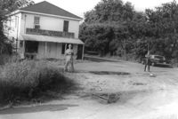
10-Mile News, on site affected by the widening of State Road 13 (Remount Road). Trailer park in background. Surveyor notations on back of photo: "Dkt.: 10.562. Property owner: Edna M. Tant. Tract: 5. Date: Jul. 12, 1967." [See collection description for explanation of surveyor notations.]
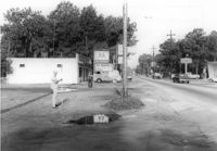
Lot next to McBride TV and Roy's Barber Shop, on site affected by the widening of State Road 13 (Remount Road). Atlantic gas Station: across the street. Surveyor notations on back of photo: "Dkt.: 10.562. Property owner: Pearl T. Leiderman. Tract: 40. Date: Jul. 19, 1967." [See collection description for explanation of surveyor notations.]
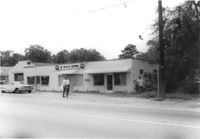
U-Nita-Do-It Yourself Store, on site affected by the widening of State Road 13 (Remount Road). Surveyor notations on back of photo: "Dkt.: 10.562. Property owner: John D. Stratos. Tract: 90. Date: Jul. 19, 1967." [See collection description for explanation of surveyor notations.]
Limit your search
SCDOT Photographs: Properties in the Right-of-Way✖[remove]3
Right of way--South Carolina--Charleston County, Highway planning--South Carolina--Charleston County, Commercial buildings--South Carolina--Charleston County, Vernacular architecture--South Carolina--Charleston County, Lost architecture--South Carolina--Charleston County✖[remove]3