Lot on site affected by the construction of the Crosstown. Address: 1 Lee Street. Surveyor notations on back of photo: "Dkt.: 10.518. Property owner: Ada Hamilton. Tract: 67. Station: 52+05 Lt. N.B. lane Route 17. Date: Mar. 7, 1963." [See collection description for explanation of surveyor notations.]
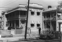
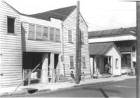
House on site affected by the construction of the Crosstown. Address: 94 Sheppard Street. Surveyor notations on back of photo: "Dkt.: 10.518. Property owner: Alice Davis. Tract: 17. Station: 30+55 Lt. Sheppard Street. Date: Mar. 6, 1963. Proximity. [See collection description for explanation of surveyor notations.]
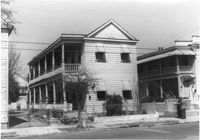
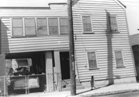
House on site affected by the construction of the Crosstown. Address: 96 Sheppard Street. Surveyor notations on back of photo: "Dkt.: 10.518. Property owner: Celia McFadden. Tract: 18. Station: 30+10 Lt. Sheppard Street. Date: Mar. 6, 1963. In R/W - Bought. [See collection description for explanation of surveyor notations.]
House on site affected by the construction of the Crosstown. Address: 96 Sheppard Street. Surveyor notations on back of photo: "Dkt.: 10.518. Property owner: Celia McFadden. Tract: 18. Station: 30+10 Lt. Sheppard Street. Date: Mar. 6, 1963. In R/W - Bought. [See collection description for explanation of surveyor notations.]
House on site affected by the construction of the Crosstown. Address: 96 Sheppard Street. Surveyor notations on back of photo: "Dkt.: 10.518. Property owner: Celia McFadden. Tract: 18. Station: 30+10 Lt. Sheppard Street. Date: Mar. 6, 1963. In R/W - Bought. [See collection description for explanation of surveyor notations.]
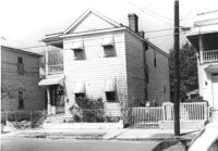
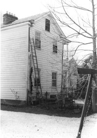
House on site affected by the construction of the Crosstown. 74 Cooper Street. Surveyor notations on back of photo: "Dkt.: 10.518. Property owner: Victoria Jenkins, Est. Tract: 21. Station: 40+30 Rt. N.B. lane Route 17. Date: Mar. 6, 1963." [See collection description for explanation of surveyor notations.]
House on site affected by the construction of the Crosstown. Address: 74 Cooper Street. Surveyor notations on back of photo: "Dkt.: 10.518. Property owner: Victoria Jenkins, Est. Tract: 21. Station: 40+30 Rt. N.B. lane Route 17. Date: Mar. 6, 1963." [See collection description for explanation of surveyor notations.]
House (rear view) on site affected by the construction of the Crosstown. Address: 74 Cooper Street. Surveyor notations on back of photo: "Dkt.: 10.518. Property owner: Victoria Jenkins, Est. Tract: 21. Station: 40+30 Rt. N.B. lane Route 17. Date: Mar. 6, 1963." [See collection description for explanation of surveyor notations.]
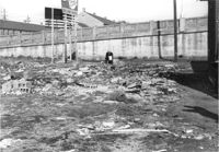
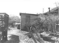
"Junk lot" behind houses on site affected by the construction of the Crosstown. Address: 171 Nassau Street. Surveyor notations on back of photo: "Dkt.: 10.518. Property owner: Samuel J. Lloyd. Tract: 24. Station: 40+70 CL N.B. lane Route 17. Date: Mar. 6, 1963. In R/W - Bought. [See collection description for explanation of surveyor notations.]
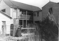
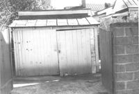
Storage shed on site affected by the construction of the Crosstown. Address182 Nassau Street. Surveyor notations on back of photo: "Dkt.: 10.518. Property owner: Euphrasia E. Lewis. Tract: 35. Station: 42+40 CL S.B. lane Route 17. Date: Mar. 6, 1963. In R/W - Bought. [See collection description for explanation of surveyor notations.]
Limit your search
SCDOT Photographs: Properties in the Right-of-Way✖[remove]157