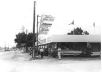
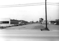
Marine Center (boat sales) on site affected by the construction of Interstate 26 (I-26). Address 4752 Rivers Avenue. View of street corner. C & R Motors in background. Possibly on Rivers Avenue. Surveyor notations on back of photo: "Dkt.: 10.486. Property owner: C.W. Keller. Tract: 33. Station: 2+75 Lt. (Line E). Date: May 30, 1961. Sign to be moved." [See collection description for explanation of surveyor notations.]
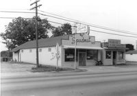
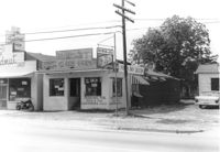
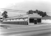
The Spudnut Shop [3646 Dorchester Road], on site affected by the construction of Interstate 26 (I-26). Front facade has stepped parapet. Neighboring building, Pick & Pay Grocery, also in photo. Surveyor notations on back of photo: "Dkt.: 10.480. Property owner: John C. Gelegotes, et al. Tract: 164. Station: 5681+50 on CL. Date: May 30, 1961. In R/W - Bought." [See collection description for explanation of surveyor notations.]
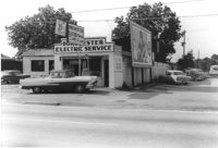
Dorchester Electric Service (side view) on site affected by the construction of Interstate 26 (I-26). Building address number 3640 [possibly Dorchester Road]. Billboard for Swift's Premium Meats for Babies on side of building. Surveyor notations on back of photo: "Dkt.: 10.480. Property owner: Laura B. Beaufort. Tract: 167. Station: 5681+40 Lt. Date: May 30, 1961. In R/W - Bought." [See collection description for explanation of surveyor notations.]
Terrace Market on site affected by the construction of Interstate 26 (I-26). Building is closed. Sunbeam Bread sign on side of building. Front facade has stepped parapet. Surveyor notations on back of photo: "Dkt.: 10.480. Property owner: John C. Gelegotes, et al. Tract: 163. Station: 5681+00 Rt. Date: May 30, 1961. In R/W - Bought." [See collection description for explanation of surveyor notations.]
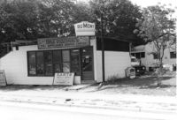
DuMont Television / Patterson's TV & Appliance Service Center / Karts Sales & Service on Dorchester Road, on site affected by the construction of Interstate 26 (I-26). Surveyor notations on back of photo: "Dkt.: 10.480. Property owner: Mrs. Margaret H. Patterson. Tract: 181. Station: 134+15 (Rt. (Route 642) [Dorchester Road]. Date: May 31, 1961. In R/W - Bought." [See collection description for explanation of surveyor notations.]
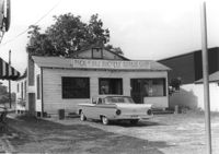
Pick & Pay Bicycle Repair Shop on site affected by the construction of Interstate 26 (I-26). Surveyor notations on back of photo: "Dkt.: 10.480. Property owner: G.S. Carter, Sr. Tract: 166. Station: 5681+50 Lt. Date: May 30, 1961. In R/W - Bought." [See collection description for explanation of surveyor notations.]
Health Club building and lot, on site affected by the construction of Interstate 26 (I-26). Nilson Storage Warehouse in background. Surveyor notations on back of photo: "Dkt.: 10.480. Property owner: G.S. Carter, Sr. Tract: 162. Station: 5677+60 Rt. Date: May 30, 1961. Damaged." [See collection description for explanation of surveyor notations.]
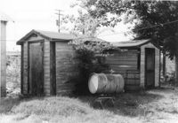
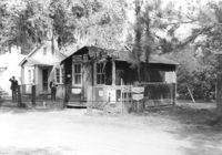
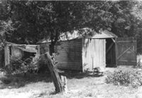
Sheds on site affected by the construction of Interstate 26 (I-26). Surveyor notations on back of photo: "Dkt.: 10.480. Property owner: Arlene Phillips, Est. Tract: 165. Station: 5681+10 Lt. Date: May 30, 1961. In R/W - Bought." [See collection description for explanation of surveyor notations.]
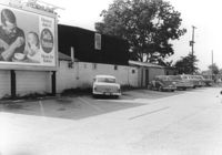
View of buildings in previous photos (Health Club, pizza restaurant, Nilson Storage Warehouse), on site affected by the construction of Interstate 26 (I-26). Surveyor notations on back of photo: "Dkt.: 10.480. Property owner: G.S. Carter, Sr. Tract: 162. Station: 5675+00 - 5679+75 Rt. & Lt. Date: May 30, 1961. View from across Route 642 [Dorchester Road]." [See collection description for explanation of surveyor notations.]
Grocery with signage for Dr. Pepper, Coca-Cola, Royal Crown Cola, Tru-Ade, Pepsi, on site affected by the construction of Interstate 26 (I-26). Neighboring house in background. Surveyor notations on back of photo: "Dkt.: 10.480. Property owner: John Chaplin. Tract: 18. Station: 5503+90 Rt. Date: May 2, 1961. In R/W - Bought." [See collection description for explanation of surveyor notations.]
Building on site affected by the construction of Interstate 26 (I-26). May have been a barber shop (striped pole posted by door). Building address number 1818. Langston Motors in background. Possibly on Rivers Avenue. Surveyor notations on back of photo: "Dkt.: 10.486. Property owner: Dora Peagler. Tract: 20. Station: 13+50 Rt. Date: May 30, 1961. In R/W - Bought." [See collection description for explanation of surveyor notations.]
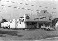
Red & White Super Market (rear view) on site affected by the construction of Interstate 26 (I-26). Surveyor notations on back of photo: "Dkt.: 10.480. Property owner: Mrs. Gladys F. Blewer. Tract: 168. Station: 136+10 Lt. (Route 642) [Dorchester Road]. Date: May 30, 1961. In R/W - Bought." [See collection description for explanation of surveyor notations.]
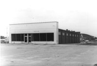
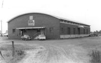
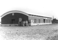
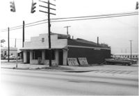
Nilson Storage Warehouse (corner view, front), a building with curved roofline, on site affected by the construction of Interstate 26 (I-26). Surveyor notations on back of photo: "Dkt.: 10.480. Property owner: G.S. Carter, Sr. Tract: 162. Station: 5674+50 on CL. Date: May 30, 1961. In R/W - Bought." [See collection description for explanation of surveyor notations.]
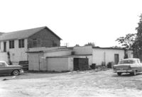
Nilson Storage Warehouse (corner view, rear), a building with curved roofline, on site affected by the construction of Interstate 26 (I-26). Surveyor notations on back of photo: "Dkt.: 10.480. Property owner: G.S. Carter, Sr. Tract: 162. Station: 5674+50 on CL. Date: May 30, 1961. In R/W - Bought." [See collection description for explanation of surveyor notations.]
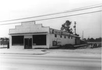
Sheds in dilapidated condition on site affected by the construction of Interstate 26 (I-26). Surveyor notations on back of photo: "Dkt.: 10.480. Property owner: C.G. Hudson. Tract: 250. Station: 5706+30 Lt. Date: May 31, 1961. In R/W - Bought." [See collection description for explanation of surveyor notations.]
Pick & Pay Grocery, on site affected by the construction of Interstate 26 (I-26). Front facade has stepped parapet. Partial view of neighboring building, The Spudnut Shop, also in photo. Surveyor notations on back of photo: "Dkt.: 10.480. Property owner: Arlene Phillips, Est. Tract: 165. Station: 5681+60 Lt. Date: May 30, 1961. In R/W - Bought." [See collection description for explanation of surveyor notations.]
Terrace Market on site affected by the construction of Interstate 26 (I-26). Building is closed. Sunbeam Bread sign on side of building. Front facade has stepped parapet. Surveyor notations on back of photo: "Dkt.: 10.480. Property owner: John C. Gelegotes, et al. Tract: 163. Station: 5681+00 Rt. Date: May 30, 1961. In R/W - Bought." [See collection description for explanation of surveyor notations.]
Dorchester Electric Service on site affected by the construction of Interstate 26 (I-26). Building address number 3640 [possibly Dorchester Road]. Front facade has stepped parapet. Partial view of Pick & Pay Bicycle Repair Shop next door. Surveyor notations on back of photo: "Dkt.: 10.480. Property owner: Laura B. Beaufort. Tract: 167. Station: 5681+40 Lt. Date: May 30, 1961. In R/W - Bought." [See collection description for explanation of surveyor notations.]
Red & White Super Market on site affected by the construction of Interstate 26 (I-26). Front facade has stepped parapet. Surveyor notations on back of photo: "Dkt.: 10.480. Property owner: Mrs. Gladys F. Blewer. Tract: 168. Station: 136+10 Lt. (Route 642) [Dorchester Road]. Date: May 30, 1961. In R/W - Bought." [See collection description for explanation of surveyor notations.]
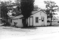
Rowell ______ Laundry Center, on site affected by the construction of Interstate 26 (I-26). Partial view of street corner. Surveyor notations on back of photo: "Dkt.: 10.480. Property owner: G.S. Carter. Tract: 162. Station: 130_00 Lt. (Route 642) [Dorchester Road]. Date: May 30, 1961. Damaged." [See collection description for explanation of surveyor notations.]
Limit your search
SCDOT Photographs: Properties in the Right-of-Way✖[remove]22