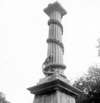
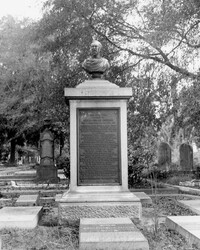
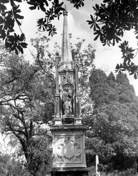
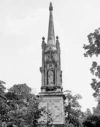
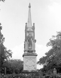
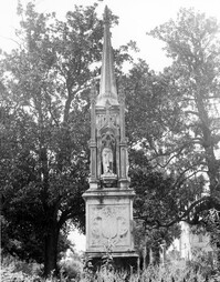
Magnolia Cemetery, Huguenin Avenue and Algonquin Road. Monument of Colonel William Washington. Detail View of column. South elevation. Charleston, S.C.;8" x 8" B/W photo. Box 5, Folder 2-1-3. Three copies.
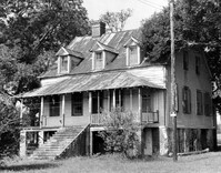
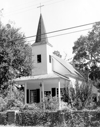
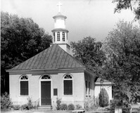
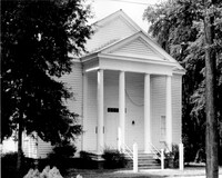
St. Andrews Episcopal Church (Mount Pleasant), 440 Whilden Street. View of SE (Front and Side) elevation. Mount Pleasant, S.C.;6.5" x 10" B/W photo. Box 13, Folder 2-8-18. One copy.
St. Andrews Episcopal Church (Mount Pleasant), 440 Whilden Street. View of East (Side) elevation. Mount Pleasant, S.C.;6.5" x 10" B/W photo. Box 13, Folder 2-8-18. Three copies.
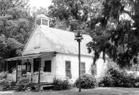
Boone Hall Plantation, Oak Avenue. Old Commissary - View of SW (Front and Side) elevation. Mount Pleasant, S.C.;6.5" x 10" B/W photo. Box 10, Folder 2-2-5. One copy.
Magnolia Cemetery, Huguenin Avenue and Algonquin Road. Monument of William Ashmead Courtenay. View of Front elevation. Charleston, S.C.;10" x 8" B/W photo. Box 5, Folder 2-1-3. One copy.
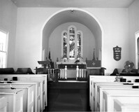
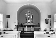
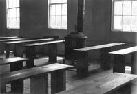
Christ Church Episcopal - Adams Run, State Highway 174. View of Interior. West (Front) elevation. Hollywood, S.C.;8" x 10" B/W photo. Box 16, Folder 2-11-12. One copy.
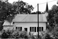
Christ Church Episcopal - Adams Run, State Highway 174. View of East (Rear) elevation. Hollywood, S.C.;8" x 10" B/W photo. Box 16, Folder 2-11-12. One copy.
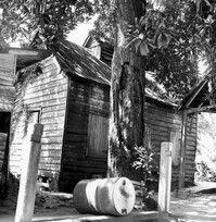
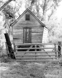
Boone Hall Plantation, Oak Avenue. Slave Cabin - View of SW (Side and Rear) elevation. Mount Pleasant, S.C.;8" x 10" B/W photo. Box 10, Folder 2-2-5. One copy.
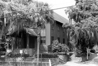
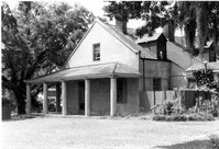
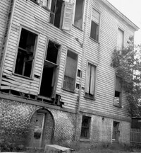
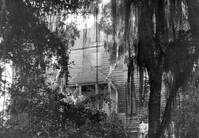
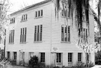
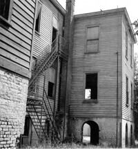
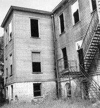
Shaw Community Center, 22 Mary Street. Main Building - View of South (Rear) elevation. Charleston, S.C. (NOTE: Structure demolished in 1974);8.25" x 7.5" B/W photo. Box 6, Folder 2-1-13. One copy.
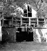
Shaw Community Center, 22 Mary Street. Coach House - View of NW elevation. Charleston, S.C. (NOTE: Structure demolished in 1974);8.25" x 7.5" B/W photo. Box 6, Folder 2-1-13. One copy.
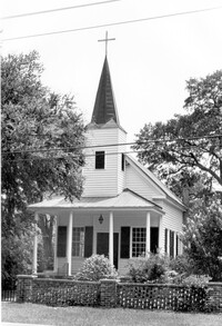
Christ Church Episcopal - Adams Run, State Highway 174. View of West (Front) elevation. Hollywood, S.C.;10" x 8" B/W photo. Box 16, Folder 2-11-12. One copy.
Magnolia Cemetery, Huguenin Avenue and Algonquin Road. Monument of Emma Heyward Haskell. Charleston, S.C.;8" x 8" B/W photo. Box 5, Folder 2-1-3. One copy.
Christ Church (Christ Episcopal Church), 2304 U.S. Highway 17. View of North (Front) elevation. Mount Pleasant, S.C.;8" x 10" B/W photo. Box 10, Folder 2-2-6. One copy.
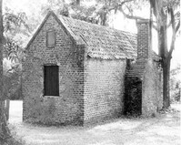
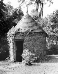
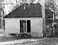
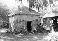
Bleak Hall Plantation, S.C. Hwy. 174. Smoke House - View of SW (Front) elevation. Edisto Island, S.C.;10" x 8" B/W photo. Box 10, Folder 2-3-2. One copy.
Boone Hall Plantation, Oak Avenue. Gin House - View of NE (Front) elevation, looking East. Mount Pleasant, S.C.;6.5" x 10" B/W photo. Box 10, Folder 2-2-5. One copy.
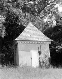
Boone Hall Plantation, Oak Avenue. Smoke House - View of NW (Front and Side) elevation. Mount Pleasant, S.C.;10" x 8" B/W photo. Box 10, Folder 2-2-5. One copy.
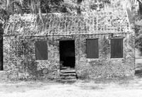
Boone Hall Plantation, Oak Avenue. Slave Cabin - View of North (Front) elevation. Mount Pleasant, S.C.;6.5" x 10" B/W photo. Box 10, Folder 2-2-5. One copy.
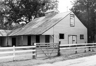
Boone Hall Plantation, Oak Avenue. Rat Proof Barn - View of South (Front) elevation. Mount Pleasant, S.C.;10" x 8" B/W photo. Box 10, Folder 2-2-5. One copy.
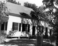
White Church (St. Thomas Church, The Brick Church), Off of Cainhoy Road. Vestry - View of Side elevation. Cainhoy, S.C.;8" x 10" B/W photo. Box 4, Folder 1-12-2. One copy.
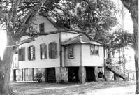
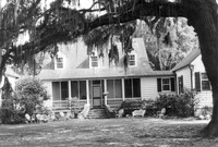
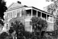
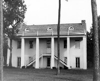
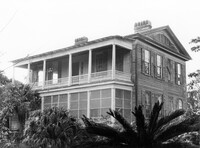
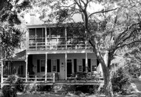
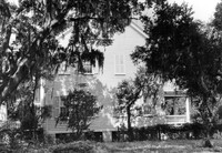
Oakland Plantation (Youghall Plantation), 1164 Porcher Bluff Road. Main House - View of SW (Side and Rear) elevation. Mount Pleasant, S.C.;10" x 8" B/W photo. Box 10, Folder 2-2-10. One copy.
Oakland Plantation (Youghall Plantation), 1164 Porcher Bluff Road. Kitchen House - View of NE (Front) elevation. Mount Pleasant, S.C.;6.5" x 10" B/W photo. Box 10, Folder 2-2-10. One copy.
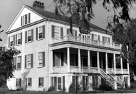
Oakland Plantation (Youghall Plantation), 1164 Porcher Bluff Road. Main House - View of North (Front) elevation. Mount Pleasant, S.C.;6.5" x 10" B/W photo. Box 10, Folder 2-2-10. One copy.
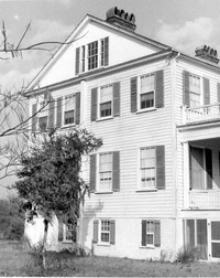
Oakland Plantation (Youghall Plantation), 1164 Porcher Bluff Road. Main House - View of South (Rear) elevation. Mount Pleasant, S.C.;6.5" x 10" B/W photo. Box 10, Folder 2-2-10. One copy.
Magnolia Cemetery, Huguenin Avenue and Algonquin Road. Monument of Sarah F., Charles F., and Elbert P. Jones. View of North elevation. Charleston, S.C.;10" x 8" B/W photo. Box 5, Folder 2-1-3. One copy.
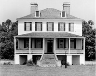
Peter's Point Plantation, off S.C. Hwy 174 on County Road 764 (Peters Point Road). View of North (Side and Front) elevation. Edisto Island, S.C.;6.5" x 10" B/W photo. Box 11, Folder 2-3-17. Two copies.
Peter's Point Plantation, off S.C. Hwy 174 on County Road 764 (Peters Point Road). View of West (Side and Rear) elevation. Edisto Island, S.C.;10" x 6.5" B/W photo. Box 11, Folder 2-3-17. One copy.
Windsor Plantation (Little Edisto Plantation, Ashwood Plantation), S.C. Hwy. 174. View of NE (Front and Side) elevation. Edisto Island, S.C.;6.5" x 10" B/W photo. Box 11, Folder 2-3-18. One copy.
Windsor Plantation (Little Edisto Plantation, Ashwood Plantation), S.C. Hwy. 174. View of NE (Side and Front) elevation. Edisto Island, S.C.;10" x 8" B/W photo. Box 11, Folder 2-3-18. One copy.
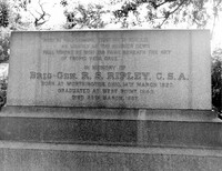
Magnolia Cemetery, Huguenin Avenue and Algonquin Road. Tombstone of R.S. Ripley. View of South elevation. Charleston, S.C.;8" x 10" B/W photo. Box 5, Folder 2-1-3. One copy.
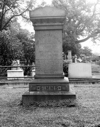
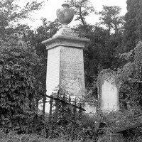
Magnolia Cemetery, Huguenin Avenue and Algonquin Road. Tombstone of William Gilmore Simms. Charleston, S.C.;10" x 8" B/W photo. Box 5, Folder 2-1-3. One copy.
Christ Church Episcopal - Adams Run, State Highway 174. View of Interior. West (Front) elevation. Hollywood, S.C.;6.5" x 10" B/W photo. Box 16, Folder 2-11-12. Three copies.
Christ Church Episcopal - Adams Run, State Highway 174. View of North (Side) elevation. Hollywood, S.C.;6.5" x 10" B/W photo. Box 16, Folder 2-11-12. Three copies.
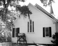
Christ Church Episcopal - Adams Run, State Highway 174. View of West (Front) elevation. Hollywood, S.C.;10" x 6.5" B/W photo. Box 16, Folder 2-11-12. Three copies.
Christ Church Episcopal - Adams Run, State Highway 174. View of South (Side) elevation. Hollywood, S.C.;8" x 10" B/W photo. Box 16, Folder 2-11-12. One copy.
Rockville Historic District - Cornelia J. Whaley House, Grace Chapel Road. View of South (Front) elevation. Wadmalaw Island, S.C.;8" x 6.5" (and 6.5" x 10") B/W photo. Box 17, Folder 2-14-19. Three copies.
Magnolia Cemetery, Huguenin Avenue and Algonquin Road. Monument of Sarah F., Charles F., and Elbert P. Jones. View of East elevation. Charleston, S.C.;10" x 8" B/W photo. Box 5, Folder 2-1-3. One copy.
Magnolia Cemetery, Huguenin Avenue and Algonquin Road. Monument of Sarah F., Charles F., and Elbert P. Jones. View of West elevation. Charleston, S.C.;10" x 8" B/W photo. Box 5, Folder 2-1-3. One copy.
Magnolia Cemetery, Huguenin Avenue and Algonquin Road. Tombstone of Thomas Bennett. View of Front and Side elevation. Charleston, S.C.;8" x 8" B/W photo. Box 5, Folder 2-1-3. One copy.
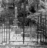
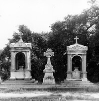
Magnolia Cemetery, Huguenin Avenue and Algonquin Road. Trapier-Jervey Gate. View of Front elevation. Charleston, S.C.;8" x 8" B/W photo. Box 5, Folder 2-1-3. One copy.
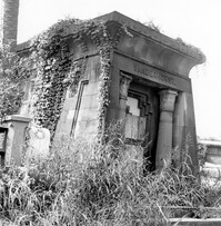
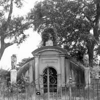
Magnolia Cemetery, Huguenin Avenue and Algonquin Road. Vanderhorst Mausoleum. View of Front and Side elevation. Charleston, S.C.;8" x 8" B/W photo. Box 5, Folder 2-1-3. One copy.
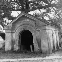
Magnolia Cemetery, Huguenin Avenue and Algonquin Road. Gibbes Mausoleum. View of Front elevation. Charleston, S.C.;8" x 8" B/W photo. Box 5, Folder 2-1-3. One copy.
Boone Hall Plantation, Oak Avenue. Stable - View of SW (Front and Side) elevation. Mount Pleasant, S.C.;6.5" x 10" B/W photo. Box 10, Folder 2-2-5. One copy.
Mount Pleasant Presbyterian Church, 302 Hibben Street (NE corner of Hibben and Church Street). View of SE (Front) elevation. Mount Pleasant, S.C.;6.5" x 10" (and 8" x 10") B/W photo. Box 13, Folder 2-8-6. Two copies.
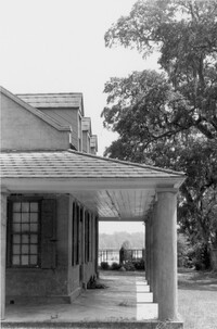
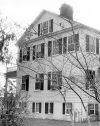
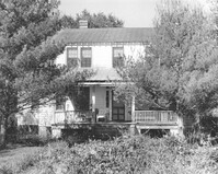
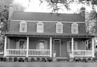
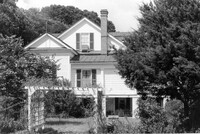
Captain Peter Lewis House, 206 Live Oak Drive. View of South (Front) elevation. Mount Pleasant, S.C.;6.5" x 10" B/W photo. Box 13, Folder 2-8-12. One copy.
Captain Peter Lewis House, 206 Live Oak Drive. View of South (Front) elevation. Mount Pleasant, S.C.;8" x 10" B/W photo. Box 13, Folder 2-8-12. Three copies.
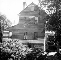
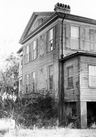
Dean Hall Plantation - Overseers House. View of East (Front) elevation. Oakley, SC. NOTE: Property relocated to Moncks Corner, S.C.;8" x 10" B/W photo. Box 2, Folder 1-8-9. One copy.
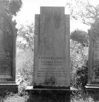
Magnolia Cemetery, Huguenin Avenue and Algonquin Road. Tombstone of R. Barnwell Rhett. View of ESE elevation. Charleston, S.C.;8" x 8" B/W photo. Box 5, Folder 2-1-3. One copy.
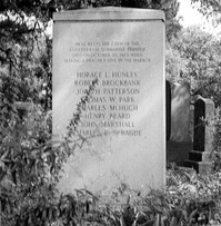
Magnolia Cemetery, Huguenin Avenue and Algonquin Road. Hunley Monument. View of North elevation. Charleston, S.C.;8" x 8" B/W photo. Box 5, Folder 2-1-3. One copy.
Peter's Point Plantation, off S.C. Hwy 174 on County Road 764 (Peters Point Road). View of NW (Front) elevation. Edisto Island, S.C.;6.5" x 10" B/W photo. Box 11, Folder 2-3-17. One copy.
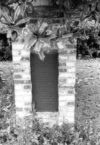
Quarter House Fort & Tavern Site, Success Street (between Meeting Street Road and Rivers Avenue). Detail View of Tavern Entrance Post and Historical Marker. Front and Side elevation. North Charleston, S.C.;10" x 6.5" B/W photo. Box 5, Folder 2-1-10. One copy.
Arnoldus Vander Horst House (Kiawah House), Mansion Court. Detail View of Entrance. South (Front) elevation. Kiawah Island, S.C.;10" x 8" B/W photo. Box 12, Folder 2-6-1. One copy.
Arnoldus Vander Horst House (Kiawah House), Mansion Court. View of North (Rear) elevation. Kiawah Island, S.C.;8" x 10" B/W photo. Box 12, Folder 2-6-1. One copy.
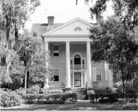
Arnoldus Vander Horst House (Kiawah House), Mansion Court. View of South (Front) elevation. Kiawah Island, S.C.;6.5" x 10" B/W photo. Box 12, Folder 2-6-1. One copy.
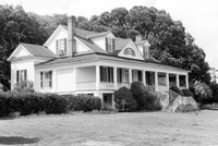
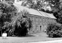
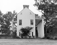
Halidon Hill Plantation (Quinby Plantation), Approximately 0.5 mile SE from Halidon Hill Lane and Cainhoy Road (S.C. Hwy 98). Main House - View of SW (Side and Front) elevation. Huger, S.C.;8" x 10" B/W photo. Box 4, Folder 1-12-6. One copy.
Magnolia Cemetery, Huguenin Avenue and Algonquin Road. Monument of Sarah F., Charles F., and Elbert P. Jones. View of South elevation. Charleston, S.C.;10" x 8" B/W photo. Box 5, Folder 2-1-3. One copy.
Rockville Historic District - Rockville Presbyterian Church, 2479 Sea Island Yacht Club Road. View of NW (Rear and Side) elevation. Wadmalaw Island, S.C.;6.5" x 10" B/W photo. Box 17, Folder 2-14-10. Two copies.
Rockville Historic District - Rockville Presbyterian Church, 2479 Sea Island Yacht Club Road. View of South (Front) elevation. Wadmalaw Island, S.C.;10" x 6.5" B/W photo. Box 17, Folder 2-14-10. One copy.
Rockville Historic District - Rockville Presbyterian Church, 2479 Sea Island Yacht Club Road. View of South (Front) elevation. Wadmalaw Island, S.C.;8" x 10" B/W photo. Box 17, Folder 2-14-10. One copy.
Captain Peter Lewis House, 206 Live Oak Drive. View of West (Side) elevation. Mount Pleasant, S.C.;6.5" x 10" B/W photo. Box 13, Folder 2-8-12. Two copies.
Secessionville Manor (Secessionville Plantation), Battallion Drive. View of NE (Side and Waterfront) elevation. Charleston, S.C.;6.5" x 10" B/W photo. Box 12, Folder 2-4-6. One copy.
North Chachan Plantation, Chachan Drive. Pavilion - View of Side and Front elevation. Moncks Corner, SC.;8" x 10" B/W photo. Box 2, Folder 1-3-2. One copy.
Stiles Point Plantation (Stiles-Hinson-Thompson House), 940 Paul Revere Drive. View of East (Side) elevation - Rear addition only. Charleston S.C.;6.5" x 10" B/W photo. Box 12, Folder 2-4-7. One copy.
Stiles Point Plantation (Stiles-Hinson-Thompson House), 940 Paul Revere Drive. View of NE (Front and Side) elevation. Charleston S.C.;6.5" x 10" B/W photo. Box 12, Folder 2-4-7. One copy.
Stiles Point Plantation (Stiles-Hinson-Thompson House), 940 Paul Revere Drive. View of North (Front) elevation. Charleston S.C.;6.5" x 10" B/W photo. Box 12, Folder 2-4-7. One copy.
McLeod Plantation, 325 Country Club Drive. Main House - View of South (Front) elevation. Charleston, S.C.;6.5" x 10" B/W photo. Box 12, Folder 2-4-5. One copy.
McLeod Plantation, 325 Country Club Drive. Main House - View of East (Side) elevation. Charleston, S.C.;8" x 10" B/W photo. Box 12, Folder 2-4-5. One copy.
Quarter House Fort & Tavern Site, Success Street (between Meeting Street Road and Rivers Avenue). Detail View of Tavern Entrance Post and Historical Marker. Front elevation. North Charleston, S.C.;10" x 6.5" B/W photo. Box 5, Folder 2-1-10. One copy.
Quarter House Fort & Tavern Site, Success Street (between Meeting Street Road and Rivers Avenue). View of SE elevation. North Charleston, S.C.;6.5" x 10" B/W photo. Box 5, Folder 2-1-10. One copy.
Quarter House Fort & Tavern Site, Success Street (between Meeting Street Road and Rivers Avenue). View of SE elevation. North Charleston, S.C.;6.5" x 10" B/W photo. Box 5, Folder 2-1-10. One copy.
Oakland Plantation (Youghall Plantation), 1164 Porcher Bluff Road. Smoke House - View of NE (Front and Side) elevation. Mount Pleasant, S.C.;6.5" x 10" B/W photo. Box 10, Folder 2-2-10. One copy.
Dean Hall Plantation - Overseers House. View of North (Side) elevation. Oakley, SC. NOTE: Property relocated to Moncks Corner, S.C.;8" x 10" B/W photo. Box 2, Folder 1-8-9. One copy.
Shaw Community Center, 22 Mary Street. Main Building - View of SE (Side and Rear) elevation. Charleston, S.C. (NOTE: Structure demolished in 1974);8.25" x 7.5" B/W photo. Box 6, Folder 2-1-13. One copy.
Shaw Community Center, 22 Mary Street. Main Building - View of SW (Rear and Side) elevation. Charleston, S.C. (NOTE: Structure demolished in 1974);8.25" x 7.5" B/W photo. Box 6, Folder 2-1-13. One copy.
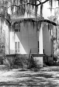
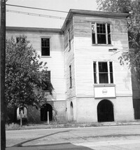
Shaw Community Center, 22 Mary Street. Main Building - View of North (Front) elevation. Charleston, S.C. (NOTE: Structure demolished in 1974);8.25" x 7.5" B/W photo. Box 6, Folder 2-1-13. One copy.
Limit your search
Photos from the Records of The Historic Preservation Planner, BCD-COG✖[remove]197