Rockville Historic District - Joseph LaRoche House, Sea Island Yacht Club Road. View of North (Front) elevation. Wadmalaw Island, S.C.;8" x 10" B/W photo. Box 17, Folder 2-14-6. One copy.
Rockville Historic District - Joseph LaRoche House, Sea Island Yacht Club Road. View of West (Side) elevation. Wadmalaw Island, S.C.;8" x 10" B/W photo. Box 17, Folder 2-14-6. One copy.
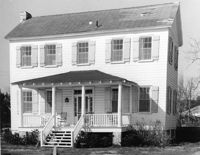
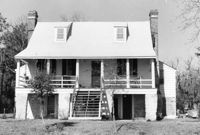
Rockville Historic District - John F. Townsend House, Sea Island Yacht Club Road. View of NE (Front and Side) elevation. Wadmalaw Island, S.C.;8" x 10" B/W photo. Box 17, Folder 2-14-7. One copy.
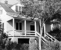
Rockville Historic District - John F. Townsend House, Sea Island Yacht Club Road. Detail View of Front Porch, NE (Front and Side) elevation.. Wadmalaw Island, S.C.;8" x 10" B/W photo. Box 17, Folder 2-14-7. One copy.
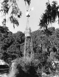
Rockville Historic District - Wilson's Windmill, Sea Island Yacht Club Road. South elevation. Wadmalaw Island, S.C.;10" x 8" B/W photo. Box 17, Folder 2-14-9. One copy.
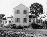
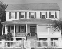
Rockville Historic District - Old Episcopal Rectory, Maybank Highway. View of South (Front) elevation. Wadmalaw Island, S.C.;6.5" x 10" (and 8" x 10") B/W photo. Box 17, Folder 2-14-13. Two copies.
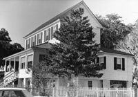
Rockville Historic District - Old Episcopal Rectory, Maybank Highway. View of SE (Side and Front) elevation. Wadmalaw Island, S.C.;6.5" x 10" B/W photo. Box 17, Folder 2-14-13. One copy.
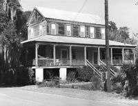
Rockville Historic District - Perry House, Maybank Highway. View of South (Front) elevation. Wadmalaw Island, S.C.;6.5" x 10" B/W photo. Box 17, Folder 2-14-14. One copy.
Rockville Historic District - W.E. Jenkins House (James LaRoche House), Maybank Highway. View of South (Front) elevation. Wadmalaw Island, S.C.;6.5" x 10" (and 8" x 10") B/W photo. Box 17, Folder 2-14-15. Two copies.
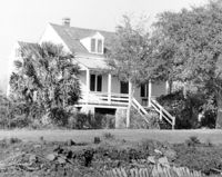
Rockville Historic District - Hagood House (Micah Jenkins House), Grace Chapel Road. View of South (Front) elevation. Wadmalaw Island, S.C.;6.5" x 10" B/W photo. Box 17, Folder 2-14-16. One copy.
Limit your search
Photos from the Records of The Historic Preservation Planner, BCD-COG✖[remove]18