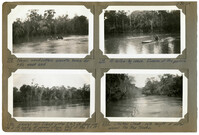
Image #222 (2.75" x 4.5"): "3-30-29. An obstruction in the Chicken Creek channel. Note the water back in the woods."; Image #223 (2.75" x 4.5"): "3-30-29. The motor boat which was used to tow small rafts to the Santee Bridge."; Image #224 (2.75" x 4.5"): "3-30-29. 7 to 8 Ft. of water over the 'mainland' where piles were being cut."; Image #225 (2.75" x 4.5"): "3-30-29. A 90 ft. cypress tree, felled from a boat. Must be cleared and floated out.";Four 4.5" x 2.75" B/W photos numbered 222, 223, 224, 225
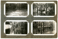
Image #218 (2.75" x 4.5"): "3-30-29. Negro wood-cutters enroute home for the week end."; Image #219 (2.75" x 4.5"): "3-30-29. A hollow-log canoe. Duncan at the paddle."; Image #220 (2.75" x 4.5"): "3-30-29. Laurel Hill Island - water 2 to 3 ft. deep over the 5 ft. banks at normal stage. Most of the 85 ft. and 90 ft. piling came from here."; Image #221 (2.75" x 4.5"): "3-30-29. Chicken Creek - note height of water around the tree trunks.";Four 4.5" x 2.75" B/W photos numbered 218, 219, 220, 221
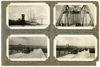
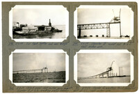
Image #561 (2.75" x 4.5"): "8-8-29. Four-masted Belgian Training ship lying at P.U.C. Dock. Masts 185 ft. high."; Image #562 (2.75" x 4.5"): "8-8-29. The opening day. First cars going east, coming from Charleston."; Image #562 (2.75" x 4.5"): "8-8-29. Free traffic till 4:00 P.M.! Cars now traveling in both directions."; Image #564 (2.75" x 4.5"): "8-9-29. Camera man ready to take movies of the floats parade - 2nd day of bridge opening.";Four 4.5" x 2.75" B/W photos numbered 561, 562, 562, 564
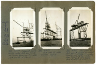
Image #422 (2.75" x 4.5"): "6-11-29. Traveler B (left) at L15 & truss to L16. Traveler A (east side) at L12 and truss to L14."; Image #423 (2.75" x 4.5"): "6-12-29. West cantilever arm complete except floor L16 to L17. Eye-bar hangers U17 L17 being erected."; Image #424 (2.75" x 4.5"): "6-12-29. Assembling eye-bars U17 L17 to joint L17 (See 420)."; Image #425 (2.75" x 4.5"): "6-12-29. Driving 10" pin at U17 with 500lb. overhauling ball - west cantilever arm.";Four 4.5" x 2.75" B/W photos numbered 422, 423, 424, 425
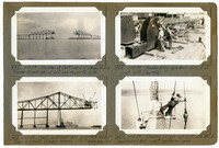
Image #14 (2.75" x 4.5"): "12-4-28. Progress. Complete to span 9W."; Image #19 (2.75" x 4.5"): "12-13-29. Complete to 5W and erecting bent 3W."; Images #17, 18 (2.75" x 4.5"): "12-8-28. Wreck on West Approach after runaway of 14 ton girder which pushed locomotive down grade ahead of it.";Four 4.5" x 2.75" B/W photos numbered 14, 17, 18, 19
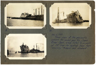
Images #8, 10, 12 (2.75" x 4.5"): Caption under all photos: Dec. 2, 1928. Three views of pneumatic caisson for anchor pier #10, Cooper River Span, which tilted to an angle 29 [degrees] from the vertical. Seven negro 'sand-hogs' trapped and drowned.";Three 4.5" x 2.75" B/W photos numbered 8, 10, 12
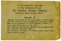
A Photographic Record of the Construction of the Cooper River Bridge; Charleston, South Carolina - 1928-29; Volume II; Showing the erection of the Cooper River Cantilever Span, 1050 feet center to center of main piers, and being at the time of its completion the fifth longest cantilever, or truss span of any kind in the world. Steel furnished by McClintic-Marshall Co. and erected by the Pottstown Erection Dep't. Small photos by E.L. Durkee. 5" x 7" Photos by James Smyth ("Irish"). Larger photos as noted.;Title Page, 6.75" x 10.125"
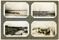
Image #298 (2.75" x 4.5"): "5-6-29. Our tank lighter and coal barge."; Image #299 (2.75" x 4.5"): "5-6-29. Traveler "B" moved out to L2. West anchor arm."; Image #300 (2.75" x 4.5"): "5-8-29. Second panel--west anchor arm complete. Traveler Bat L3, erecting portal bracing."; Image #301 (2.75" x 4.5"): "5-9-29. Traveler B erecting third falsework bent at L6, west anchor arm.";Four 4.5" x 2.75" B/W photos numbered 298, 299, 300, 301
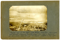
Unnumbered Image (5" x 7"): "Airplane view of the Cooper River Bridge - looking east. May 9, 1929. West approach, in foreground, completely paved. Town Creek in foreground, then Drum Island, Cooper River, and Mt. Pleasant. Charleston in lower right.";One 5" x 7" B/W photo
Limit your search
Photographic Record of the Cooper River Bridge✖[remove]202