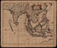
This map was engraved by Johannes L'Huilier and corrected by Frederick de Wit (1630-1706). The map encompasses the regions from India to Southern China, Taiwan, the Philippines, the East Indies and Indonesia with parts of northwest Australia identified as Hollandia Nova. Many islands with their ports are shown. The title cartouche at the top right is surrounded by turbaned warriors and native figures. 52 x 62cm.
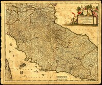
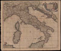
Map of central Italy by Frederick de Wit (1630-1706) showing the grand duchy of Tuscany and the papal states. Title cartouche is decorated with the ball-motif shield of the Medici family; the papal states are represented by the Keys of St. Peter on a shield. Detail on the map includes a road that extends from Rimina on the Gulf of Venetia to Piacenza in the northeast. Amsterdam. 52 x 62cm.
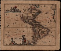
In this map by Gerrit van Schagen (1642-1690) California is a large island, there is one Great Lake (Lac contenant), a large open lake in place of the western Great Lakes, and the conjectural Northwest Passage, with the Straits of Anian. The elaborate title cartouche at the bottom left contains scenes of native Americans hunting, panning for gold and a chief standing beneath an umbrella. Also, the map shows other small illustrations: a war being waged by Indians in South America and a figure lying in a hammock. There is a large vignette at the top left of Neptune and his sons, the Tritons. 51 x 62cm.
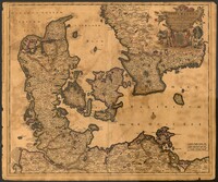
Map of Denmark with the Baltic Sea and the southern portion of Sweden by Justus Danckerts (1635-1701). Title cartouche displays the Danish coat of arms. 52 x 62cm.
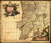
Map of Portugal and Algarve by Johannes de Ram (1648-1693). The title cartouche in the upper left depicts cherubs holding the Portuguese coat of arms; a note within the cartouche explains that the longitudinal lines on the map are based from the prime meridian that runs through Tenerife in the Canary Islands. The scale cartouche in the lower right features Neptune with a trident and two cherubs holding the coat of arms of Algarve, then a semi-autonomous region of Portugal. Amsterdam. 52 x 62cm.
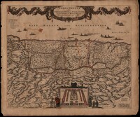
This map was engraved by Frederick de Wit (1630-1706), one of the most prominent and successful publishers in Amsterdam. The Holy Land extends from Sidon and Damascus to the Wilderness of Pharan in the Sinai. The decoration in the map relates to the Old Testament. At the bottom of the map is a depiction of an encampment of the Israelites during Exodus. The Twelve Tribes are around the perimeter and in the center the Tabernacle is illustrated with the Levites in attendance. Moses is at the left holding his staff and his brother Aaron is opposite. The caption in the sea refers to Lebanese cedars being sent by King Hiram of Tyre to King Solomon. The theme of the richness of the Promised Land is emphasized with the beautiful garland supported by the angels across the top, containing fruit, grapes and flowers. North oriented to the right. Amsterdam. 52 x 62cm.
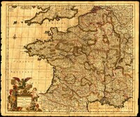
Map of France by Justus Danckerts (1635-1701) includes Belgium and Luxembourg and parts of Switzerland, the Netherlands, Germany and England. Title cartouche depicts a Roman soldier and other allegorical figures. Amsterdam. 52 x 62cm.
Map of Scandinavia by Justus Danckerts (1635-1701) includes the Baltic and part of Russia. The title cartouche with an armorer's forge and Swedish coat of arms probably alludes to Sweden's power in the late seventeenth century. 52 x 62cm
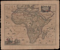
The map by Gerritt Van Schagen (1642-1690) captures the European misconceptions of Africa typical of the late seventeenth century. The Nile appears to be rising from the three lakes of Zaire, Zembre and Zafflan. The prime meridian, the zero-degree longitude line, is plotted through the Canary Islands which to the ancients was the western edge of the inhabited world. The interior is decorated with monkeys, elephants, lions, rhinoceroses, leopard and ostriches. The sea is decorated with ships, whales and flying fish. The title cartouche in the upper left right is surrounded by two Africans, one holding a scorpion and the other a cornucopia with sea sprites at their feet. The elaborate decoration at the lower left is Neptune surrounded by his wife, Amphitrite, and their sons, the Tritons, along with Nereids, the sea nymphs. 52 x 62cm.
Map of the Italian piedmont by Thomas Blaeu (1596-1673). Similar to Tabula Generalis Sabaudiae by Blaeu and slightly overlapping in coverage. First published by Blaeu's heirs after his death in his town book of Savoy and Piedmont. Map was designed by Giovanni Tommaso Borgonio (1620-1683) and engraved by Johannes de Broen (1649-1730). Amsterdam. 52 x 62cm.
Ornate map of Savoy in the French alps by Joan Blaeu (1596-1673). Map is richly detailed with pictorial relief of mountains and watersheds. Putti hold the coat of arms of the dukes of Savoy above the title cartouche in the lower left corner. Other family crests from the regional duchies and baronies ring the map. First published by Blaeu's heirs after his death in his town book of Savoy and Piedmont (Theatrum Sabaudiae). Map was designed by Giovanni Tommaso Borgonio (1620-1683) and engraved by Johannes de Broen (1649-1730). Amsterdam. 52 x 62cm.
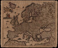
Map of Europe by Justus Danckerts (1635-1701) includes western Russia and Iceland. The title cartouche on left supported by putti. Other embellishments show the abduction of Europa by Zeus, a sea monster and ships on the oceans. Amsterdam. 52 x 62cm.
This double hemisphere map by Justus Danckerts (1635-1701) is accompanied by two small hemispheres based on the North and South Poles. The South Pole only includes the southernmost tip of South America. The North Pole shows parts of North America, Europe, and Asia. Four scenes surround the map and symbolize the four elements: fire, air, earth and water. In the upper left scene fire is symbolized with a scene of war and destruction and by Cerberus, the three-headed dog who guarded the gate to Hades. The upper right scene is of air with Olympus and the zodiac. The bottom left depicts earth with a pastoral scene symbolizing peace. Ships, a sea monster (whale), Neptune with his wife Amphitrite and their sons, the Tritons, all represent water in the lower right scene. "M King" 1811" written on upper right. Amsterdam. 52 x 62cm.
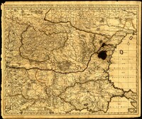
One of three maps by Nicolaes Visscher (1649-1702) collectively showing the entire length of the Danube. This map covers the middle part of the river from Linz through Vienna, Bratislava and Budapest, to just east of Belgrade. Amsterdam. 52 x 62cm.
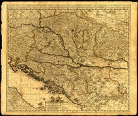
One of three maps by Nicolaes Visscher (1649-1702) collectively showing the entire length of the Danube. This map depicts the lower Danube from Belgrade to its mouth in the Black Sea. Amsterdam. 52 x 62cm.
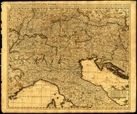
One of three maps by Nicolaes Visscher (1649-1702) collectively showing the entire length of the Danube. This map depicts the upper Danube from its start in Germany to Bratislava (Presburg on map). Amsterdam. 52 x 62cm.
Map of Belgium by Nicolaes Visscher (1649-1702) with Luxembourg and parts of France, the Netherlands and Germany. Title cartouche in upper right corner shows resting warriors and cherubs. A harvest scene surrounds the scale in the lower left corner. Amsterdam. 52 x 62cm.
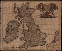
Map of the British Isles by Theodore Danckerts (1663-1727) also includes part of the European coast. The decorative title cartouche is in the upper right corner with putti supporting the shields of Scotland, Ireland and England; the mileage scale is given in the lower left corner. Amsterdam. 52 x 62cm.