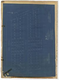
Page 202 of the City Engineer's Plat Book with one plat. The plat shows lots located between Brigade Street and Williman Street, and between Meeting Street and a strip of land labelled "Atlantic Coast Line R.R." It also shows Nassau Street and Doran Street.
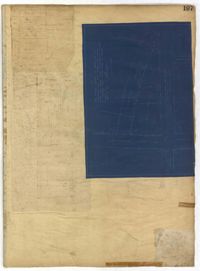
Page 197 of the City Engineer's Plat Book with three plats. Plat 1 shows lots near the intersection of Payne Street and Nunan Street. Plat 2 shows land near President Street and Congress Street. The last plat shows land located near the intersection of Lenwood Street and Gibbes Street, and also shows Lowndes Street.
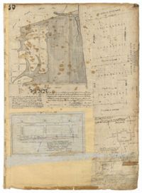
Page 35 of the City Engineer's Plat Book with five plats. Plat 1 shows land located near a creek with large portions marked with a different color. The plat shows a square labelled as "The Mall," and numerous streets, including Bay Street, Drake Street, America Street, Hanover Street, Columbus Street, Cooper Street, Blake Street, Amhurst Street, and Reid Street. There's also a stretch labelled as "Braggs Marsh." Plat 2 shows lots located between Congress Street and Mount Street, including a stretch of Hope Place. Plat 3 features a building labelled "Exchange," on East Bay Street, and near Gibbes Street and Champney Street. Plat 4 shows land with a partition wall and kitchen yards. Plat 5 shows land located near the "Citadel Athletic Field" and Grove Street.