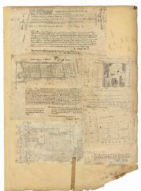
Page 11 of the City Engineer's Plat Book with five plats. Plat 1 shows a plot of land on the Charleston Harbor located near the intersection of East Bay Street and Queen Street. Plat 2 shows lots located between Conin Creek and King Street, and between Vanderhorst Street and "Manigault alias Boundary Street." Plat 3 shows plots and buildings located near the intersection of Liberty Street and St. Philip Street. Plat 4 features a plots, including one belonging to the "German Lutheran Church," located between King Street and Archdale Street.