Search
« Previous |
11 - 20 of 203
|
Next »
Search Results
Date:
1886
Description:
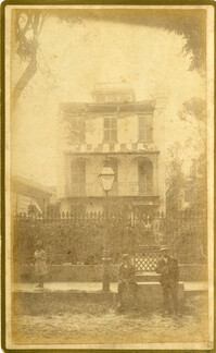
Caption: 'Cook's Earthquake Views of Charleston and Vicinity. Taken after the 31st of August, 1886. No.98, residence in Bull Street.'
Date:
1886
Description:
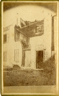
Caption: 'Cook's Earthquake Views of Charleston and Vicinity. Series No.2. No.171, a kitchen, Beaufain Street.'
Date:
1886
Description:
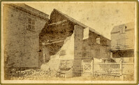
Caption: 'Cook's Earthquake Views of Charlston and Vicinity. Series No.2. No.165, ruins in Bedon's Alley.'
Date:
1886
Description:
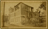
Caption: 'Cook's Earthquake Views of Charleston and Vicinity. Taken after the 31st of August, 1886. No.137, Smith Street, cor[ner] Montague [sic].'
Date:
1886
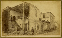
Description:
Caption: 'Cook's Earthquake Views of Charleston and Vicinity. Taken after the 31st of August, 1886. No.41, Corner of Tradd and Friend Streets.'
Date:
1886
Description:
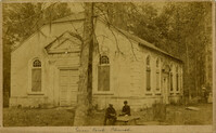
Handwritten at bottom, front: 'Goose Creek Church.'
Date:
1886
Description:
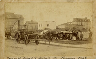
Charleston Earthquake scene. Handwritten at bottom, front: 'Corner of Broad & Friend Streets, Firemens [sic] Tent.'
Date:
1886
Description:
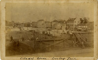
Charleston Earthquake scene. Handwritten at bottom, front: 'Citadel Green. Erecting Tents.'
Date:
1886
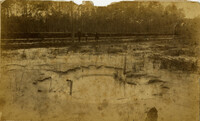
Description:
Charleston Earthquake scene. Possibly No.54 of Cook's Earthquake Views. Round geyser at Ten Mile Hill.
Date:
1886
Description:
Caption: 'Cook's Earthquake Views of Charleston and Vicinity. Taken after the 31st of August, 1886. No.125, Scene near Atlantic Wharf.' Charleston city directory for 1886 lists Atlantic Wharf at the rear of the Post Office.