Search
« Previous |
201 - 300 of 1,613
|
Next »
Search Results
Date:
1977-1983
Description:
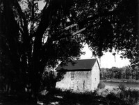
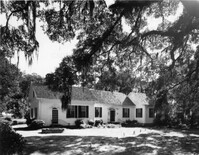
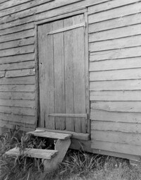
Georgetown County, Chicora Wood Plantation, ca. 1819. Laundry Building - View of SW (Side and Front) elevation. 4" x 5" B/W photo.
Date:
1977-1983
Description:
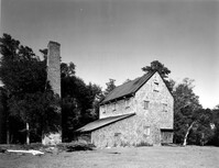
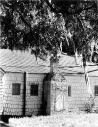
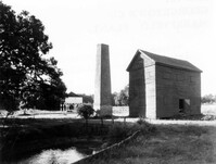
Georgetown County, Chicora Wood Plantation, ca. 1819. Rice Threshing Mill with Chimney Stack - View of SW (front and Side) elevation. 4" x 5" B/W photo.
Date:
1977-1983
Description:
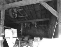
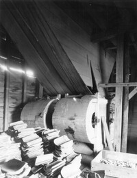
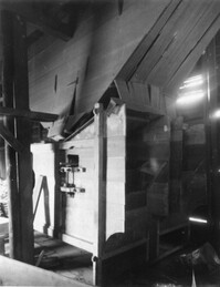
Georgetown County, Chicora Wood Plantation, ca. 1819. Rice Threshing Mill - Interior View of threshers, North elevation. 4" x 5" B/W photo.
Date:
1977-1983
Description:
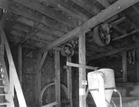
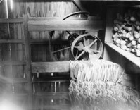
Georgetown County, Chicora Wood Plantation, ca. 1819. Rice Threshing Mill - Interior View showing pulleys for belt connections to threshers and boilers. 4" x 5" B/W photo.
Date:
1977-1983
Description:
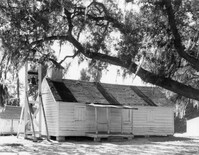
Georgetown County, Chicora Wood Plantation, ca. 1819. Rice Shipping House - View of SW (Rear and Side) elevation. 4" x 5" B/W photo.
Date:
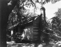
1977-1983
Description:
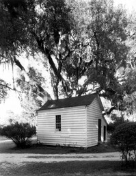
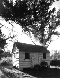
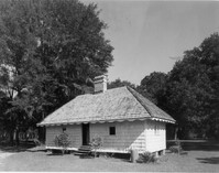
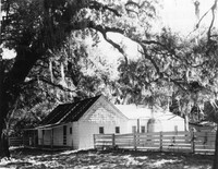
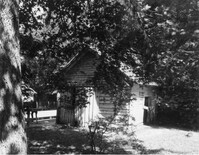
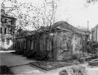
Georgetown County, Chicora Wood Plantation, ca. 1819. Cabin - View of Front elevation (possibly a slave cabin). 4" x 5" B/W photo.
Date:
1977-1983
Description:
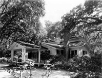
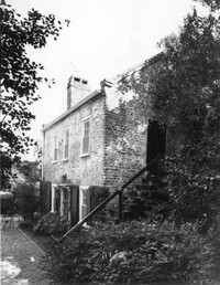
Georgetown County, Dirleton Plantation, ca. 1825. View of East (Front) elevation. 4" x 5" B/W photo.
Date:
1977-1983
Description:
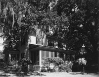
Georgetown County, Dirleton Plantation, ca. 1825. View of West (Rear and Side) elevation. 4" x 5" B/W photo.
Date:
1977-1983
Description:
Georgetown County, Hopsewee Plantation, ca. 1740. Slave Quarters, North Building. 4" x 5" B/W photo.
Date:
1977-1983
Description:
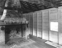
Georgetown County, Hopsewee Plantation, ca. 1740. Slave Quarters, North Building - Interior View. East Room (West elevation) showing fireplace. 4" x 5" B/W photo.
Date:
1977-1983
Description:
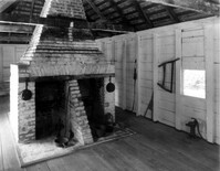
Georgetown County, Hopsewee Plantation, ca. 1740. Slave Quarters, South Building - Interior View. East Room (West elevation) showing double fireplace. 4" x 5" B/W photo.
Date:
1977-1983
Description:
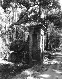
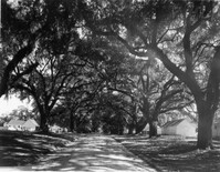
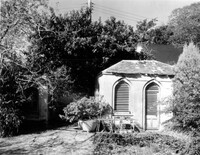
Georgetown County, Mansfield Plantation, ca. 1718. View of Brick gate post. 4" x 5" B/W photo.
Date:
1977-1983
Description:
Georgetown County, Mansfield Plantation, ca. 1718. View of Oak Allee. 4" x 5" B/W photo.
Date:
1977-1983
Description:
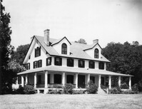
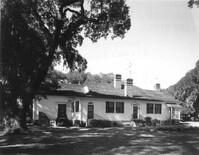
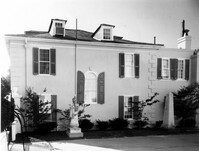
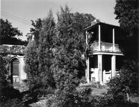
Georgetown County, Mansfield Plantation, ca. 1780. Main House - View of West (Front) elevation. 4" x 5" B/W photo.
Date:
1977-1983
Description:
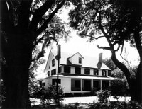
Georgetown County, Mansfield Plantation, ca. 1780. Main House - View of East (Rear) elevation. 4" x 5" B/W photo.
Date:
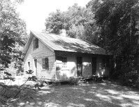
1977-1983
Description:
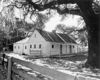
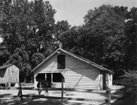
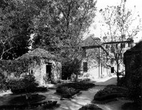
Georgetown County, Mansfield Plantation, ca. 1780. Slave Quarters - View of Side and Front elevation. 4" x 5" B/W photo.
Date:
1977-1983
Description:
Georgetown County, Mansfield Plantation, ca. 1780. Slave Quarters - View of Side and Front elevation. 4" x 5" B/W photo.
Date:
1977-1983
Description:
Georgetown County, Mansfield Plantation, ca. 1780. Slave Quarters - Detail View of chimney. 4" x 5" B/W photo.
Date:
1977-1983
Description:
Georgetown County, Mansfield Plantation, ca. 1780. Schoolhouse - View of North (Front) elevation. 4" x 5" B/W photo.
Date:
1977-1983
Description:
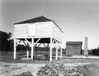
Georgetown County, Mansfield Plantation, ca. 1780. Winnowing House - View of Front elevation (Rice Threshing Mill in background). 4" x 5" B/W photo.
Date:
1977-1983
Description:
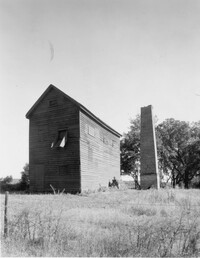
Georgetown County, Mansfield Plantation, ca. 1780. Rice Threshing Mill and Chimney Stack - View of Side and Rear elevation. 4" x 5" B/W photo.
Date:
1977-1983
Description:
Georgetown County, Mansfield Plantation, ca. 1780. Rice Threshing Mill and Chimney Stack - View of Front and Side elevation. 4" x 5" B/W photo.
Date:
1977-1983
Description:
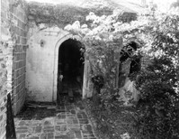
Georgetown County, Mansfield Plantation, ca. 1780. Rice Threshing Mill - Detail View of entrance. 4" x 5" B/W photo.
Date:
1977-1983
Description:
Georgetown County, Mansfield Plantation, ca. 1780. Rice Threshing Mill - Interior View. Threshers, SW elevation. 4" x 5" B/W photo.
Date:
1977-1983
Description:
Georgetown County, Mansfield Plantation, ca. 1780. Rice Threshing Mill - Interior View. Threshers, SE elevation. 4" x 5" B/W photo.
Date:
1977-1983
Description:
Georgetown County, Mansfield Plantation, ca. 1780. Rice Threshing Mill - Interior View. Pulleys for belt connection from boiler to thresher. 4" x 5" B/W photo.
Date:
1977-1983
Description:
Georgetown County, Wicklow Hall Plantation, ca. 1825. Main House - View of North (Front) elevation. 4" x 5" B/W photo.
Date:
1977-1983
Description:
Georgetown County, Wicklow Hall Plantation, ca. 1825. Main House - View of South (Rear) elevation. 4" x 5" B/W photo.
Date:
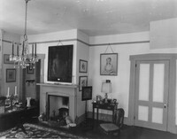
1977-1983
Description:
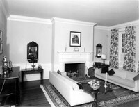
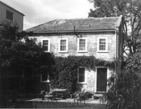
Georgetown County, Wicklow Hall Plantation, ca. 1825. Main House - Interior View. 1st Floor - SW Room, North elevation. 4" x 5" B/W photo.
Date:
1977-1983
Description:
Georgetown County, Wicklow Hall Plantation, ca. 1825. Kitchen Building - View of Side and Front elevation. 4" x 5" B/W photo.
Date:
1977-1983
Description:
Georgetown County, Wicklow Hall Plantation, ca. 1825. Slave Quarters - View of Side and Front elevation. 4" x 5" B/W photo.
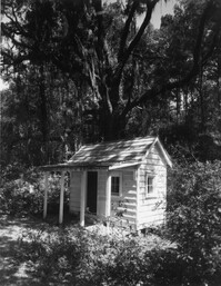
Date:
1977-1983
Description:
Georgetown County, Wicklow Hall Plantation, ca. 1825. Playhouse - View of Front and Side elevation. 4" x 5" B/W photo.
Date:
1977-1983
Description:
Georgetown County, Wicklow Hall Plantation, ca. 1825. Carriage House - View of Front and Side elevation. 4" x 5" B/W photo.
Date:
1977-1983
Description:
Georgetown County, Wicklow Hall Plantation, ca. 1825. Barn - View of Front and Side elevation. 4" x 5" B/W photo.
Date:
1977-1983
Description:
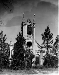
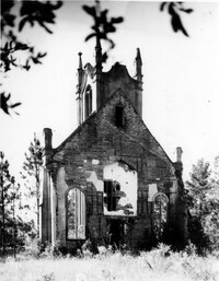
Georgetown County, Prince Frederick's Episcopal Church (Ruins), ca. 1859. View of West (Front) elevation. 4" x 5" B/W photo.
Date:
1977-1983
Description:
Georgetown County, Prince Frederick's Episcopal Church (Ruins), ca. 1859. View of South (Side) elevation. 4" x 5" B/W photo.
Date:
1977-1983
Description:
Georgetown County, Prince Frederick's Episcopal Church (Ruins), ca. 1859. View of East (Rear) elevation. 4" x 5" B/W photo.
Date:
1977-1983
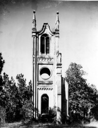
Description:
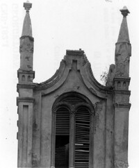
Georgetown County, Prince Frederick's Episcopal Church (Ruins), ca. 1859. Detail View of Bell Tower, South (Side) elevation. 4" x 5" B/W photo.
Date:
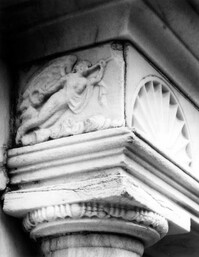
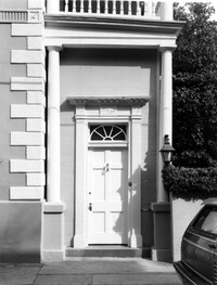
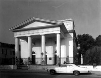
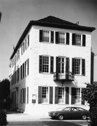
1977-1983
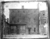
Description:
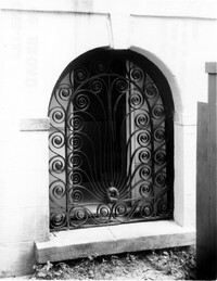
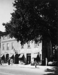
80 Broad Street, Charleston City Hall, ca. 1800. Detail View of Ground Floor arched window grille, North (Rear) elevation. 4" x 5" B/W photo.
Date:
1977-1983
Description:
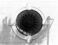
80 Broad Street, Charleston City Hall, ca. 1800. Detail view of Ground Floor circular window grille, West (Side) elevation. 4" x 5" B/W photo.
Date:
1977-1983
Description:
80 Broad Street, Charleston City Hall, ca. 1800. Detail view of Ground Floor entry cornice, South (Front) elevation. 4" x 5" B/W photo.
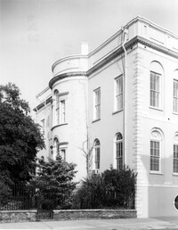
Date:
1977-1983
Description:
80 Broad Street, Charleston City Hall, ca. 1800. View of NW (Rear and Side) elevation. 4" x 5" B/W photo.
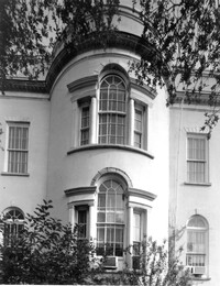
Date:
1977-1983
Description:
80 Broad Street, Charleston City Hall, ca. 1800. Detail View of bay windows, North (Rear) elevation. 4" x 5" B/W photo.
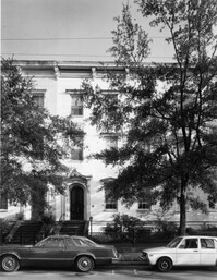
Date:
1977-1983
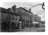
Description:
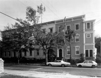
101 - 107 Bull Street, Bee's Row, ca. 1853. Detail View of 103, North (Front) elevation. 4" x 5" B/W photo.
Date:
1977-1983
Description:
101 - 107 Bull Street, Bee's Row, ca. 1853. View of North (Front) elevation. 4" x 5" B/W photo.
Date:
1977-1983
Description:
101 - 107 Bull Street, Bee's Row, ca. 1853. Detail View of entries to 101 and 103, North (Front) elevation. 4" x 5" B/W photo.
Date:
1977-1983
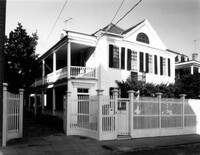
Description:
19 Church Street, George Williams Coach House, ca. 1875. View of SE (Front and Side) elevation. 4" x 5" B/W photo.
Date:
1977-1983
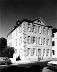
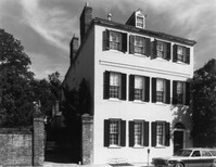
Description:
20 Church Street, William Holmes House, ca. 1809. View of SW (Front and Side) elevation. 4" x 5" B/W photo.
Date:
1977-1983
Description:
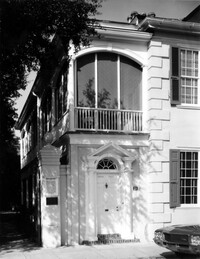
20 Church Street, William Holmes House, ca. 1809. Detail View of entry, South (Front) elevation. 4" x 5" B/W photo.
Date:
1977-1983
Description:
35 Church Street, Young-Johnson House, ca. 1770. View of SE (Front and Side) elevation. 4" x 5" B/W photo.
Date:
1977-1983
Description:
37 Church Street, George Matthews House, ca. 1743. View of SE (Front and Side) elevation. 4" x 5" B/W photo.
Date:
1977-1983
Description:
38 Church Street, Dr. Vincent Le Seigneur House, ca. 1819. View of SW (Front and Side) elevation. 4" x 5" B/W photo.
Date:
1977-1983
Description:
38 Church Street, Dr. Vincent Le Seigneur House, ca. 1819. View of North (Rear) elevation. 4" x 5" B/W photo.
Date:
1977-1983
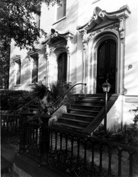
Description:
38 Church Street, Dr. Vincent Le Seigneur House, ca. 1819. Detail View of house and garden entries, South (Front) elevation. 4" x 5" B/W photo.
Date:
1977-1983
Description:
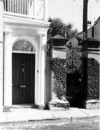
39 Church Street, George Everleigh House, ca. 1743. View of South (Front) elevation. 4" x 5" B/W photo.
Date:
1977-1983
Description:
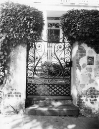
39 Church Street, George Everleigh House, ca. 1743. Detail View of wrought iron gate, South (Front) elevation. 4" x 5" B/W photo.
Date:
1977-1983
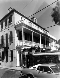
Description:
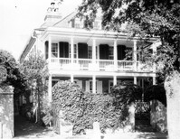
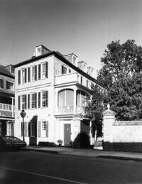
59 Church Street, Thomas Rose House, ca. 1735. View of SE (Front and Side) elevation. 4" x 5" B/W photo.
Date:
1977-1983
Description:
59 Church Street, Thomas Rose House, ca. 1735. View of North (Rear) elevation. 4" x 5" B/W photo.
Date:
1977-1983
Description:
59 Church Street, Thomas Rose House, ca. 1735. Detail View of entry, East (Front) elevation. 4" x 5" B/W photo.
Date:
1977-1983
Description:
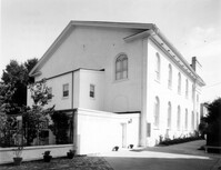
61 Church Street, First Baptist Church, ca. 1822. View of SW (Rear and Side) elevation. 4" x 5" B/W photo.
Date:
1977-1983
Description:
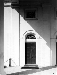
61 Church Street, First Baptist Church, ca. 1822. Detail View of south end entry, East (Front) elevation. 4" x 5" B/W photo.
Date:
1977-1983
Description:
61 Church Street, First Baptist Church, ca. 1822. View of East (Front) elevation. 4" x 5" B/W photo.
Date:
1977-1983
Description:
69 Church Street, Capers-Motte House, ca. 1745. View of SE (Front and Side) elevation. 4" x 5" B/W photo.
Date:
1977-1983
Description:
69 Church Street, Capers-Motte House, ca. 1745. View of West (Rear) elevation. 4" x 5" B/W photo.
Date:
1977-1983
Description:
69 Church Street, Capers-Motte House, ca. 1745. View of Kitchen and Slave Quarters, South (Front) elevation. 4" x 5" B/W photo.
Date:
1977-1983
Description:
69 Church Street, Capers-Motte House, ca. 1745. View of Kitchen and Slave Quarters and Laundry Building (on left), SW (Front and Side) elevation. 4" x 5" B/W photo.
Date:
1977-1983
Description:
69 Church Street, Capers-Motte House, ca. 1745. View of Laundry Building and Privy (on left), South (Front) elevation. 4" x 5" B/W photo.
Date:
1977-1983
Description:
69 Church Street, Capers-Motte House, ca. 1745. View of Stable, East (Front) elevation. 4" x 5" B/W photo.
Date:
1977-1983
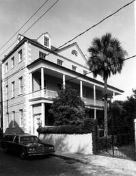
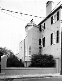
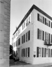
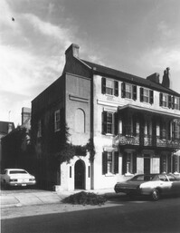
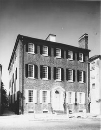
Description:
71 Church Street, Col. Robert Brewton House, ca.1732. View of SE (Side and Front) elevation. 4" x 5" B/W photo.
Date:
1977-1983
Description:
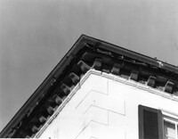
71 Church Street, Col. Robert Brewton House, ca.1732. Detail View of brick cornice. 4" x 5" B/W photo.
Date:
1977-1983
Description:
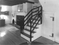
71 Church Street, Col. Robert Brewton House, ca.1732. Interior View. 2nd Floor - West Room, North elevation. 4" x 5" B/W photo.
Date:
1977-1983
Description:
71 Church Street, Col. Robert Brewton House, ca.1732. View of SE (Front and Side) elevation. 4" x 5" B/W photo.
Date:
1977-1983
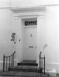
Description:
71 Church Street, Col. Robert Brewton House, ca.1732. Detail View of entry, South (Front) elevation 4" x 5" B/W photo.
Date:
1977-1983
Description:
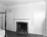
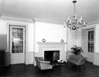
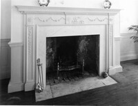
71 Church Street, Col. Robert Brewton House, ca.1732. Interior View. 1st Floor - East Room, North elevation. 4" x 5" B/W photo.
Date:
1977-1983
Description:
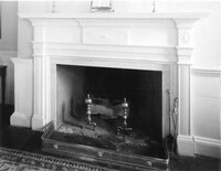
71 Church Street, Col. Robert Brewton House, ca.1732. Interior view. 1st Floor - East Room, North elevation. Detail of mantle. 4" x 5" B/W photo.
Date:
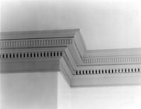
1977-1983
Description:
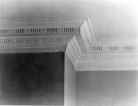
71 Church Street, Col. Robert Brewton House, ca.1732. Interior view. 1st Floor - East Room, North elevation. Detail of room cornice. 4" x 5" B/W photo.
Date:
1977-1983
Description:
71 Church Street, Col. Robert Brewton House, ca.1732. Interior View. 2nd Floor - East Room, North elevation. 4" x 5" B/W photo.
Date:
1977-1983
Description:
71 Church Street, Col. Robert Brewton House, ca.1732. Interior view. 2nd Floor - East Room, North elevation. Detail of mantle. 4" x 5" B/W photo.
Date:
1977-1983
Description:
71 Church Street, Col. Robert Brewton House, ca.1732. Interior View. 2nd Floor - East Room, North elevation. Detail of cornice. 4" x 5" B/W photo.
Date:
1977-1983
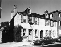
Description:
76 Church Street, Dubose Heyward House, ca.1785. View of SW (Front and Side) elevation. 4" x 5" B/W photo.
Date:
1977-1983
Description:
78 Church Street, ca. 1785. View of SE (Front and Side) elevation. 4" x 5" B/W photo.
Date:
1977-1983
Description:
83 - 85 Church Street, Cabbage Row (William Hendricks House), ca. 1749. View of SE (Front and Side) elevation. 4" x 5" B/W photo.
Date:
1977-1983
Description:
86 Church Street, Isaac Mazyck House, ca. 1783. View of NW (Front and Side) elevation. 4" x 5" B/W photo.
Date:
1977-1983
Description:
86 Church Street, Isaac Mazyck House, ca. 1783. South Dependency, View of NW (Front and Side) elevation. 4" x 5" B/W photo.
Date:
1977-1983
Description:
86 Church Street, Isaac Mazyck House, ca. 1783. North Dependency, View of South (Front) elevation. 4" x 5" B/W photo.
Date:
1977-1983
Description:
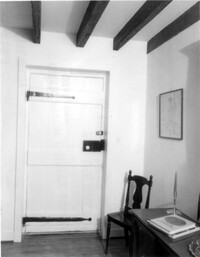
86 Church Street, Isaac Mazyck House, ca. 1783. North Dependency - Interior View. Detail of West entry on South side. 4" x 5" B/W photo.
Date:
1977-1983
Description:
86 Church Street, Isaac Mazyck House, ca. 1783. North Dependency - Interior View. Kitchen - North wall from West entry on South side. 4" x 5" B/W photo.
Date:
1977-1983
Description:
86 Church Street, Isaac Mazyck House, ca. 1783. North Dependency - Interior View. Kitchen - North wall from East entry on South side. 4" x 5" B/W photo.
Date:
1977-1983
Description:
87 Church Street, Heyward-Washington House, ca. 1770. Copy of 1833 photo. Main House - View of East (Front) elevation. 4" x 5" B/W photo.
Date:
1977-1983
Description:
87 Church Street, Heyward-Washington House, ca. 1770. Copy of 1929 photo. Main House - View of East (Front) elevation. 4" x 5" B/W photo.
Date:
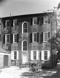
1977-1983
Description:
87 Church Street, Heyward-Washington House, ca. 1770. Main House - View of SE (Front and Side) elevation. 4" x 5" B/W photo.
Date:
1977-1983
Description:
87 Church Street, Heyward-Washington House, ca. 1770. Main House - View of West (Rear) elevation. 4" x 5" B/W photo.
Date:
1977-1983
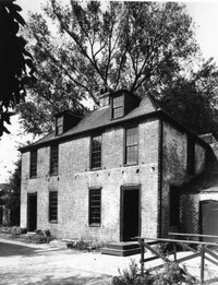
Description:
87 Church Street, Heyward-Washington House, ca. 1770. Kitchen House - View of SE (Front and Side) elevation. 4" x 5" B/W photo.
Date:
1977-1983
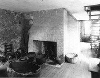
Description:
87 Church Street, Heyward-Washington House, ca. 1770. Kitchen House - Interior View. West Room, East elevation. 4" x 5" B/W photo.
Date:
1977-1983
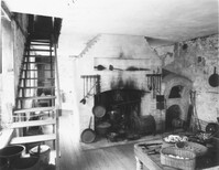
Description:
87 Church Street, Heyward-Washington House, ca. 1770. Kitchen House - Interior View. East Room, West elevation. 4" x 5" B/W photo.
Date:
1977-1983
Description:
87 Church Street, Heyward-Washington House, ca. 1770. Stable (19th century addition) - View of NW (Side and Front) elevation. 4" x 5" B/W photo.
Date:
1977-1983
Description:
87 Church Street, Heyward-Washington House, ca. 1770. Privy, Kitchen House, and Stable (from left to right) - View of NE (Front and Side) elevation. 4" x 5" B/W photo.
Date:
1977-1983
Description:
89 - 91 Church Street, Catfish Row, ca. 1783. View of NE (Front and Side) elevation. 4" x 5" B/W photo.
Date:
1977-1983
Description:
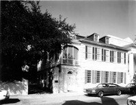
90 Church Street, Thomas Legare House, ca. 1759. Main House - View of SW (Front and Side) elevation. 4" x 5" B/W photo.
Date:
1977-1983
Description:
90 Church Street, Thomas Legare House, ca. 1759. Dependencies - View of North (Side) elevation. Shows diaper pattern masonry and horse stall vents. 4" x 5" B/W photo.