A four-page typed document chronicling the history of the Ansonborough property from 1696 with Isaac Mazyck's Propietary Grant through the segmentation of the property beginning in 1759 through a purchase in 1904. The development of the various streets in the Ansonborough area and the building of houses is also discussed.
A one-page typed document chronicling the history of 66 Anson Street, 40 Society Street, and 42 Society Street, from the fire of 1838 to launch of HCF Revolving Fund in 1958.
This two-page document describes A. C. Logan's request to subdivide 42 Hasell Street into seven apartments and lists the petitioners opposed to the request, which was ultimately denied.
This five-page handwritten document contains information about properties in Ansonborough, including address, owner, kind of building, dimensions, and 1960 assessment.
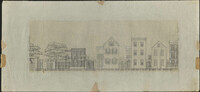
Architectural drawing of houses on the north side of Society Street. Right to left: edge of 36 Society showing piazza, 38 Society, 40 Society, 42 Society, 44 Society.
A post card printed for the National Portrait Gallery in London. On the front is a portrait of George, First Lord Anson (1697-1762); on the back is a brief biography of Anson by Philip Gosse.
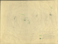
Six maps conveying plans to beautify Ansonborough, showing the footprints of buildings and annotated to indicate the status of buildings, traffic flow, and scenarios that would result from the Ansonborough Rehabilitation Project.
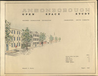
Ansonborough Open Space Study is an illustration in support of the report of the same name, created for Historic Charleston Foundation by Kenneth L. Steeves in August, 1968.
Hand-drawn and color-coded map of Ansonborough indicating properties purchased by HCF, restored by HCF, for sale by HCF, restored privately, and other distinctive antebellum houses. Created to illustrate HCF’s Ansonborough Rehabilitation Project.